Category:Sutherland State Aid Bridge
| Object location | | View all coordinates using: OpenStreetMap |
|---|
 | |||||
| Upload media | |||||
| Instance of | |||||
|---|---|---|---|---|---|
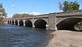
| Location | Lincoln County, Nebraska | ||||
| Crosses | |||||
| Manufacturer |
| ||||
| Heritage designation |
| ||||
| Inception |
| ||||
 | |||||
Media in category "Sutherland State Aid Bridge"
The following 9 files are in this category, out of 9 total.
-
 Sutherland State Aid Bridge arch from W.jpg 2,184 × 1,027; 938 KB
-
 Sutherland State Aid Bridge from NE 1.jpg 2,458 × 914; 937 KB
-
 Sutherland State Aid Bridge from NE 2.jpg 2,264 × 1,144; 1.09 MB
-
 Sutherland State Aid Bridge from NW.jpg 2,481 × 1,121; 1.26 MB
-
 Sutherland State Aid Bridge from S 1.jpg 1,916 × 1,237; 1.02 MB
-
 Sutherland State Aid Bridge from S 2.jpg 2,361 × 1,202; 1.19 MB
-
 Sutherland State Aid Bridge from SW.jpg 2,560 × 1,019; 1.08 MB
-
 Sutherland State Aid Bridge guardrail.jpg 1,447 × 1,694; 1.05 MB
-
 Sutherland State Aid Bridge N half from W.jpg 2,332 × 1,354; 1.25 MB


