Category:Tanner Trail
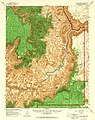
Tanner Trail descends from Lipan Point, down Escalante Butte, then Cardenas Butte, then down Tanner Canyon. Tanner Canyon lies at the easternmost end of the South Rim. The canyon lies east of w:Grandview Point, with views north into the southern region of the Colorado River, south-flowing below the East Rim.
hiking trail in Arizona  | |||||
| Upload media | |||||
| Instance of | |||||
|---|---|---|---|---|---|
| Located in protected area | |||||
| Location | Grand Canyon National Park, Mohave County, Arizona | ||||
| Length |
| ||||
| Terminus | |||||
 | |||||
Subcategories
This category has only the following subcategory.
V
Media in category "Tanner Trail"
The following 2 files are in this category, out of 2 total.
-
 Arizona. LOC 99446126-11.jpg 4,883 × 6,157; 6.27 MB
-
 Tanner Canyon.jpg 1,818 × 1,228; 2.76 MB
