Category:Temple, Midlothian
village in Midlothian, Scotland, UK  | |||||
| Upload media | |||||
| Instance of | |||||
|---|---|---|---|---|---|
| Location |
| ||||
 | |||||
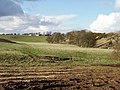
English: Temple is a village and Parish in Midlothian, Scotland. Situated to the south of Edinburgh, the village lies on the east bank of the River South-Esk.
Subcategories
This category has the following 5 subcategories, out of 5 total.
A
- Arniston House (13 F)
B
- Braidwood Bridge (6 F)
- Braidwood Farm (2 F)
O
- Old Temple Kirk (11 F)
T
- Temple quarry conveyor (3 F)
Media in category "Temple, Midlothian"
The following 29 files are in this category, out of 29 total.
-
 Christmas frost, Temple - geograph.org.uk - 845301.jpg 640 × 424; 80 KB
-
 Cottage and tree, Castleton - geograph.org.uk - 78839.jpg 480 × 640; 83 KB
-
 Cottages near Castleton Farm. - geograph.org.uk - 1001755.jpg 640 × 480; 73 KB
-
 Edgelaw Moor. - geograph.org.uk - 146235.jpg 640 × 456; 79 KB
-
 Edgelaw. - geograph.org.uk - 146226.jpg 640 × 480; 93 KB
-
 Farmland near Temple - geograph.org.uk - 1356684.jpg 640 × 480; 80 KB
-

-
 Nicely done renovation - geograph.org.uk - 834030.jpg 480 × 640; 74 KB
-
 Old mine workings near Temple - geograph.org.uk - 831200.jpg 640 × 424; 136 KB
-
 Ordnance Survey Sheet NT 35 Moorfoot Hils, Published 1955.jpg 7,180 × 7,661; 4.78 MB
-
 Parish Church, Temple, Session-house.jpg 4,611 × 3,458; 6.34 MB
-
 Permanent wetland near Temple farm - geograph.org.uk - 834043.jpg 640 × 480; 87 KB
-
 Pipeline and bridge near Temple - geograph.org.uk - 844250.jpg 640 × 424; 135 KB
-
 Purvies Hill Burn. - geograph.org.uk - 135146.jpg 640 × 480; 119 KB
-

-
 Scots Pine, Whinny Plantation - geograph.org.uk - 711072.jpg 480 × 640; 255 KB
-
 Shaw Knowe - geograph.org.uk - 761082.jpg 640 × 480; 133 KB
-
 Snow in Temple (2) - geograph.org.uk - 845319.jpg 640 × 424; 60 KB
-
 Snow in Temple - geograph.org.uk - 845310.jpg 640 × 424; 65 KB
-
 Temple Parish Church, Western Facade.jpg 2,888 × 3,851; 2.61 MB
-
 Temple Village - geograph.org.uk - 831173.jpg 640 × 426; 122 KB
-
 Temple, looking SW - geograph.org.uk - 845292.jpg 640 × 424; 89 KB
-
 Temple, Midlothian.jpg 640 × 480; 70 KB
-
 The bridge at Temple - geograph.org.uk - 834024.jpg 640 × 480; 98 KB
-
 The former Parish Church in Temple - geograph.org.uk - 328115.jpg 640 × 480; 67 KB
-
 The road to Temple, from Rosebery - geograph.org.uk - 711016.jpg 640 × 480; 112 KB
-
 Well Wood - geograph.org.uk - 845339.jpg 640 × 424; 73 KB
-
 Woodland, Castleton - geograph.org.uk - 1356690.jpg 359 × 640; 116 KB
-
 Woodland, Purvies Hill Burn - geograph.org.uk - 682529.jpg 480 × 640; 129 KB


_-_geograph.org.uk_-_845319.jpg)


