Category:Tenedo
| Object location | | View all coordinates using: OpenStreetMap |
|---|
archaeological site in Bad Zurzach in the canton of Aargau, Switzerland  | |||||
| Upload media | |||||
| Instance of | |||||
|---|---|---|---|---|---|
| Part of | |||||
| Location | Bad Zurzach, Zurzach, Zurzach District, Aargau, Switzerland | ||||
| Street address |
| ||||
| Heritage designation | |||||
 | |||||
Media in category "Tenedo"
The following 20 files are in this category, out of 20 total.
-
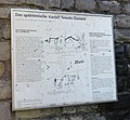 AaIMG 0295 Bad Zurzach Kirchlibuck Tenedo-Infotafel.jpg 3,130 × 2,904; 1.94 MB
-
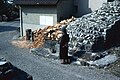 Abitazione e legnaia a ridosso delle mura del castello tardo romano a Tenedo.jpg 2,880 × 1,931; 1.33 MB
-
 Befundskizze spätrömische Kastelle in Zurzach (CH) und Rheinheim (D).png 1,512 × 1,106; 835 KB
-
 Cerco.jpg 5,273 × 3,515; 2.62 MB
-
 Hinweistafel beim Schlosspark Bad Zurzach.jpg 5,472 × 3,648; 2.62 MB
-
 Resti del castello tardo romano di Tenedo.jpg 2,816 × 1,886; 915 KB
-
 Resti della cinta muraria del castello tardo romano di Tenedo (DOI 21050).jpg 3,000 × 2,047; 1.34 MB
-
 Resti della cinta muraria del castello tardo romano di Tenedo.jpg 3,000 × 1,986; 1.1 MB
-
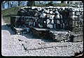 Resti della torre principale del castello tardo romano di Tenedo.jpg 3,000 × 2,063; 1.37 MB
-
 Resti delle mura del castello tardo romano di Tenedo (DOI 21038).jpg 1,832 × 2,770; 1,002 KB
-
 Resti delle mura del castello tardo romano di Tenedo (DOI 21041).jpg 3,000 × 2,042; 1.52 MB
-
 Resti delle mura del castello tardo romano di Tenedo.jpg 2,089 × 3,000; 1.02 MB
-
 Resti delle mura della torre del castello tardo romano di Tenedo.jpg 3,000 × 2,005; 1.34 MB
-
 Römerstraßen Hochrhein-Donau-Neckar.png 751 × 584; 267 KB
-
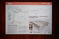
 Tenedo - Bad Zurzach.jpg 360 × 276; 63 KB
-
 Veduta con la cappella del castello di Tenedo (DOI 21034).jpg 2,075 × 3,000; 747 KB
-
 Veduta con la cappella del castello di Tenedo (DOI 21042).jpg 3,000 × 2,073; 1.03 MB
-
 Veduta con la cappella del castello di Tenedo (DOI 21043).jpg 2,088 × 3,000; 706 KB
-
 Veduta con la cappella del castello di Tenedo.jpg 3,000 × 2,059; 898 KB
-
 Zurzach roemer.jpg 2,048 × 1,536; 1.34 MB


_und_Rheinheim_(D).png)


.jpg)


.jpg)
.jpg)


.jpg)
.jpg)
.jpg)

