Category:Terrington St John

English: Terrington St John is a village and civil parish in the English county of Norfolk. The village lies to the south of the route of the A47 between Peterborough and Kings Lynn.
human settlement in United Kingdom .jpg) | |||||
| Upload media | |||||
| Instance of | |||||
|---|---|---|---|---|---|
| Location | King's Lynn and West Norfolk, Norfolk, East of England, England | ||||
| Area |
| ||||
 | |||||
Subcategories
This category has the following 2 subcategories, out of 2 total.
J
T
Media in category "Terrington St John"
The following 41 files are in this category, out of 41 total.
-

-
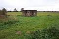 A pill box near Terrington St John - geograph.org.uk - 283721.jpg 640 × 427; 88 KB
-
 Access to the church, Terrington St. John - geograph.org.uk - 6234620.jpg 1,024 × 768; 233 KB
-
 An icy bend near St Peter's Lodge - geograph.org.uk - 2191708.jpg 2,848 × 2,136; 2.89 MB
-
 Bloomfield House Farm on School Road - geograph.org.uk - 6199654.jpg 3,456 × 2,592; 3.96 MB
-
 Butterman Field - geograph.org.uk - 6231502.jpg 1,024 × 768; 188 KB
-
 Church of St. John, Terrington - geograph.org.uk - 6234615.jpg 1,024 × 768; 116 KB
-
 Church of St. John, Terrington, east end - geograph.org.uk - 6234565.jpg 1,024 × 768; 155 KB
-

-
 Cobblers Lane - geograph.org.uk - 182233.jpg 640 × 480; 103 KB
-
 Cottages on Fence Bank - geograph.org.uk - 6234626.jpg 1,024 × 768; 193 KB
-
 Drain next to Fenditch Lane, Terrington St John - geograph.org.uk - 2204691.jpg 2,848 × 2,136; 3.03 MB
-
 Fenditch Lane - geograph.org.uk - 6236028.jpg 1,024 × 761; 175 KB
-
 Fenditch Lane and drain north of Terrington St John - geograph.org.uk - 2204694.jpg 2,848 × 2,136; 2.98 MB
-
 Fenditch Lane and the Waterlow Road Bridge - geograph.org.uk - 6236034.jpg 1,024 × 768; 165 KB
-
 Fenditch Lane looking towards Waterlow Road - geograph.org.uk - 2204698.jpg 2,848 × 2,136; 2.97 MB
-
 Five Mile Drain on a winter's day - geograph.org.uk - 2191759.jpg 2,848 × 2,136; 2.91 MB
-
 Frozen drain close to White House Farm - geograph.org.uk - 2204656.jpg 2,848 × 2,136; 3.04 MB
-
 Middle Gate Drove, St John's Highway, Norfolk - geograph.org.uk - 2191541.jpg 2,848 × 2,136; 2.95 MB
-
 Middle Gates Drove, south of St. John's Highway - geograph.org.uk - 6199642.jpg 3,456 × 2,592; 3.88 MB
-
 Old greenhouses on Hotch Lane - geograph.org.uk - 6199650.jpg 3,456 × 2,592; 3.94 MB
-
 On the edge of St John's Highway, Norfolk - geograph.org.uk - 2191418.jpg 2,848 × 2,136; 3.06 MB
-
 Pillbox, Church Lane, Terrington St John - geograph.org.uk - 2191739.jpg 2,848 × 2,136; 3.03 MB
-
 Reeds and wheat during a storm - geograph.org.uk - 1963290.jpg 2,848 × 2,136; 2.93 MB
-
 Row of tall trees, Middle Gate Drove - geograph.org.uk - 2191534.jpg 2,848 × 2,136; 3.03 MB
-
 Snowy farmland on Church Lane, Terrington St John - geograph.org.uk - 2191724.jpg 2,848 × 2,136; 2.92 MB
-
 Terrington St. John village sign (detail) - geograph.org.uk - 6151431.jpg 3,456 × 2,592; 3.79 MB
-
 Terrington St. John village sign - geograph.org.uk - 6151428.jpg 2,592 × 3,456; 3.11 MB
-
 The impressive entrance to Cedar Lodge - geograph.org.uk - 2191554.jpg 2,848 × 2,136; 2.97 MB
-
 The sign of The Woolpack Inn - geograph.org.uk - 6151422.jpg 2,592 × 3,456; 2.84 MB
-
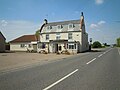
 The Woolpack Inn, Walton Highway - geograph.org.uk - 6151421.jpg 3,456 × 2,592; 3.88 MB
-
 The Woolpack, Walton Highway - geograph.org.uk - 6151418.jpg 3,456 × 2,592; 3.48 MB
-
 Tombs in the churchyard, Terrington St. John - geograph.org.uk - 6231540.jpg 1,024 × 768; 201 KB
-
 UK TerringtonStJohn.jpg 598 × 1,715; 216 KB
-
 Winter time, Terrington St John, Norfolk - geograph.org.uk - 2191401.jpg 2,848 × 2,136; 2.99 MB
-
 Woolpack Inn, Terrington St John, Norfolk, 19 05 2005.JPG 4,000 × 3,000; 2.3 MB
-
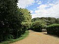
 Autumn colour on Cobbler's Lane. - geograph.org.uk - 283715.jpg 640 × 427; 95 KB
-
 Barn at White House Farm - geograph.org.uk - 283754.jpg 640 × 427; 61 KB
-
 Hay Green Piggeries - geograph.org.uk - 283757.jpg 640 × 427; 88 KB
-
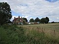
 Terrington St John village - geograph.org.uk - 279096.jpg 640 × 480; 69 KB
-


_-_geograph.org.uk_-_6151431.jpg)


