Category:Teugn
municipality of Germany    | |||||
| Upload media | |||||
| Instance of |
| ||||
|---|---|---|---|---|---|
| Part of |
| ||||
| Location | Kelheim, Lower Bavaria, Bavaria, Germany | ||||
| Head of government |
| ||||
| Population |
| ||||
| Area |
| ||||
| Elevation above sea level |
| ||||
| official website | |||||
 | |||||
Subcategories
This category has the following 3 subcategories, out of 3 total.
B
- Battle of Teugn-Hausen (4 F)
C
Media in category "Teugn"
The following 7 files are in this category, out of 7 total.
-
 DEU Teugn COA.svg 515 × 549; 122 KB
-
 Wappen Teugn.png 89 × 94; 5 KB
-
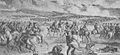 Battle of Teugen-Hausen.JPG 684 × 314; 67 KB
-
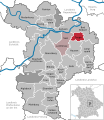
 Teugn - Lage im Landkreis.png 148 × 185; 25 KB
-
 Teugn in KEH.svg 576 × 664; 590 KB
-
 Teugn Ortsansicht.jpg 2,592 × 1,458; 2.05 MB
-
 Teugn Ortseingang.JPG 1,536 × 1,878; 2.08 MB


