Category:Thatched roofs in Leicestershire
Ceremonial counties of England: Bedfordshire · Berkshire · Buckinghamshire · Cambridgeshire · Cheshire · Cornwall · Cumbria · Derbyshire · Devon · Dorset · Durham · East Riding of Yorkshire · East Sussex · Essex · Gloucestershire · Greater London · Greater Manchester · Hampshire · Herefordshire · Hertfordshire · Kent · Lancashire · Leicestershire · Lincolnshire · Merseyside · Norfolk · North Yorkshire · Northamptonshire · Northumberland · Nottinghamshire · Oxfordshire · Rutland · Shropshire · Somerset · Staffordshire · Suffolk · Surrey · Tyne and Wear · Warwickshire · West Sussex · Wiltshire · Worcestershire
City-counties: Bristol ·
Former historic counties: Huntingdonshire ·
Other former counties:
City-counties: Bristol ·
Former historic counties: Huntingdonshire ·
Other former counties:

Subcategories
This category has the following 2 subcategories, out of 2 total.
Media in category "Thatched roofs in Leicestershire"
The following 22 files are in this category, out of 22 total.
-
 Cottage Restaurant Kegworth Grade II Listed Building SE View.jpg 4,752 × 3,168; 6.92 MB
-
 Cottage Restaurant Kegworth Grade II Listed Building SW View.jpg 4,752 × 3,168; 6.57 MB
-

-
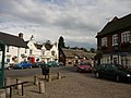 Market Bosworth Market Place - geograph.org.uk - 647715.jpg 640 × 480; 75 KB
-
 Royal Horseshoes Waltham on the Wolds Closed.JPG 3,576 × 2,276; 1.18 MB
-
 Shakespeare Braunstone.JPG 1,992 × 1,144; 439 KB
-
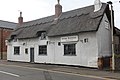
 Shakespeare Inn - geograph.org.uk - 1495948.jpg 640 × 420; 59 KB
-
 The Bakers Arms - geograph.org.uk - 571960.jpg 640 × 458; 112 KB
-
 The Blue Bell, Hoby - geograph.org.uk - 39449.jpg 640 × 480; 91 KB
-
 The Cherry Tree - geograph.org.uk - 580053.jpg 640 × 438; 97 KB
-
 The Free Trade Inn, Sileby - geograph.org.uk - 640337.jpg 640 × 480; 49 KB
-
 The main street of Shenton - geograph.org.uk - 919735.jpg 640 × 444; 86 KB
-
 Unusual thatch - geograph.org.uk - 779708.jpg 640 × 381; 86 KB
-
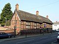 Hinckley Town Museum - geograph.org.uk - 403498.jpg 640 × 480; 108 KB
-
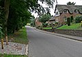
 Houses along West End in Long Whatton - geograph.org.uk - 559949.jpg 640 × 459; 108 KB
-
 Knighton Road, Leicester - geograph.org.uk - 94039.jpg 480 × 640; 107 KB
-
 Lutterworth Road, Shawell - geograph.org.uk - 595208.jpg 640 × 418; 91 KB
-
 Terraced housing on Kettering Road - geograph.org.uk - 580055.jpg 640 × 362; 84 KB
-
 Thatched building - geograph.org.uk - 205526.jpg 640 × 455; 131 KB
-
 The Bewicke Arms Inn - geograph.org.uk - 537801.jpg 640 × 429; 86 KB
-
 The Red Cow - geograph.org.uk - 420340.jpg 640 × 444; 110 KB
-


