Category:Thommanon
| Object location | | View all coordinates using: OpenStreetMap |
|---|
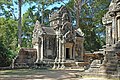
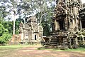
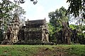
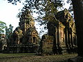
Deutsch: Der Thommanon und der Chau Say Tevoda sind zwei kleine, ursprünglich hinduistische Flachtempel in unmittelbarer Nachbarschaft der historischen Stadtanlage Angkor Thom (Kambodscha).
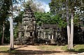
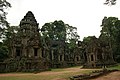
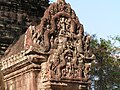
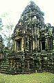
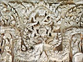
English: Thommanon at Angkor, Cambodia, is one of a pair of Hindu temples built in the end of the 11th century, completed during the reign of Suryavarman II (from 1113-1150). It is located east of the Gate of Victory of Angkor Thom.
hindu temple in Angkor, Cambodia  | |||||
| Upload media | |||||
| Instance of | |||||
|---|---|---|---|---|---|
| Part of |
| ||||
| Culture | |||||
| Location | Siem Reap, Siem Reap Municipality, Siem Reap Province, Cambodia | ||||
 | |||||
Media in category "Thommanon"
The following 84 files are in this category, out of 84 total.
-
 12th century Angkor Thommanon temple, Siem Reap Cambodia.jpg 5,100 × 3,300; 665 KB
-
 2009-09-03 09-07 Siem Reap 130 Angkor, Thommanon.jpg 4,592 × 3,056; 7.15 MB
-
 2009-09-03 09-07 Siem Reap 131 Angkor, Thommanon.jpg 4,592 × 3,056; 8.7 MB
-
 2016 Angkor, Thommanon.jpg 4,897 × 2,755; 13.46 MB
-
 20171128 Thommanon Angkor 5521 DxO.jpg 3,961 × 2,623; 14 MB
-
 20171128 Thommanon Angkor 5529 DxO.jpg 2,855 × 2,943; 8.97 MB
-
 610Thommanon.jpg 4,000 × 3,000; 2.92 MB
-
 Angkor Thommanon 2009a.jpg 4,592 × 3,056; 7.97 MB
-
 Angkor Thommanon 2009b.jpg 4,592 × 3,056; 6.68 MB
-
 Angkor Thommanon 2009c.jpg 3,056 × 4,592; 6.99 MB
-
 Angkor Thommanon temple 2009e.jpg 4,592 × 3,056; 5.88 MB
-
 Angkor-Thommanon-02-2007-gje.jpg 2,648 × 1,796; 2.67 MB
-
 Angkor-Thommanon-04-2007-gje.jpg 3,072 × 2,048; 3.05 MB
-
 Angkor-Thommanon-06-2007-gje.jpg 2,048 × 2,244; 2.72 MB
-
 Angkor-Thommanon-08-2007-gje.jpg 2,048 × 2,872; 2.8 MB
-
 Angkor-Thommanon-10-2007-gje.jpg 3,072 × 2,048; 2.75 MB
-
 Angkor-Thommanon-34-2007-gje.jpg 2,048 × 2,708; 2.82 MB
-
 Angkor-Thommanon-36-2007-gje.jpg 2,048 × 2,816; 3.2 MB
-
 Angkor-Thommanon-38-Floetenjunge-2007-gje.jpg 1,936 × 2,468; 1.65 MB
-
 Cambodge-1000a.jpg 5,760 × 2,495; 10.19 MB
-
 Decorated Entrance-Thommanon.jpg 2,272 × 1,704; 1.28 MB
-
 Exposition Angkor - Naissance d'un mythe - Louis Delaporte et le Cambodge - 004.jpg 5,184 × 3,456; 6.45 MB
-
 Exposition Angkor - Naissance d'un mythe - Louis Delaporte et le Cambodge - 005.jpg 5,184 × 3,456; 7.11 MB
-
 Exposition Angkor - Naissance d'un mythe - Louis Delaporte et le Cambodge - 006.jpg 4,807 × 2,680; 4.72 MB
-
 ICThommanon01.jpg 3,280 × 2,170; 1.58 MB
-
 ICThommanon02.jpg 2,170 × 3,304; 1.38 MB
-
 ICThommanon03.jpg 2,122 × 3,269; 1.62 MB
-
 ICThommanon04.jpg 2,170 × 3,304; 1.46 MB
-
 ICThommanon05.jpg 2,170 × 3,304; 1.46 MB
-
 ICThommanon06.jpg 2,131 × 3,273; 1.65 MB
-
 L'exposition "Angkor - la naissance d'un mythe" (musée Guimet) (11804396084).jpg 1,330 × 1,004; 954 KB
-
 Linteau du sanctuaire (Thommanon, Angkor) (6990869711).jpg 1,536 × 1,024; 1.11 MB
-
 Thommanon (9718357315).jpg 5,184 × 3,456; 3.03 MB
-
 Thommanon (9718359607).jpg 5,184 × 3,456; 4 MB
-
 Thommanon (9718362395).jpg 5,184 × 3,456; 3.97 MB
-
 Thommanon (9718364627).jpg 3,456 × 5,184; 3.65 MB
-
 Thommanon (9718372963).jpg 5,184 × 3,456; 2.33 MB
-
 Thommanon (9718382487).jpg 5,184 × 3,456; 3.74 MB
-
 Thommanon (9718383215).jpg 5,184 × 3,456; 3.23 MB
-
 Thommanon (9718384731).jpg 3,456 × 5,184; 4.74 MB
-
 Thommanon (9718397193).jpg 3,456 × 5,184; 4.42 MB
-
 Thommanon (9718398179).jpg 3,456 × 5,184; 3.97 MB
-
 Thommanon (9718409933).jpg 3,456 × 5,184; 4.83 MB
-
 Thommanon (9718424451).jpg 5,184 × 3,456; 4.01 MB
-
 Thommanon (9721587316).jpg 3,456 × 5,184; 3.06 MB
-
 Thommanon (9721589582).jpg 5,184 × 3,456; 3.41 MB
-
 Thommanon (9721596132).jpg 5,184 × 3,456; 3.1 MB
-
 Thommanon (9721597094).jpg 5,184 × 3,456; 3.24 MB
-
 Thommanon (9721598216).jpg 5,184 × 3,456; 3.08 MB
-
 Thommanon (9721600174).jpg 5,184 × 3,456; 3.03 MB
-
 Thommanon (9721602600).jpg 5,184 × 3,456; 2.9 MB
-
 Thommanon (9721605814).jpg 3,456 × 5,184; 2.64 MB
-
 Thommanon (9721621274).jpg 5,184 × 3,456; 3.77 MB
-
 Thommanon (9721622470).jpg 5,184 × 3,456; 2.84 MB
-
 Thommanon (Angkor) (6844744004).jpg 1,530 × 1,024; 1.88 MB
-
 Thommanon (Angkor) (6844745654).jpg 1,365 × 1,024; 1.09 MB
-
 Thommanon (Angkor) (6990868069).jpg 1,536 × 1,024; 1.77 MB
-
 Thommanon 02.jpg 516 × 800; 177 KB
-
 Thommanon 04.jpg 533 × 800; 178 KB
-
 Thommanon 2009 2.jpg 2,304 × 3,072; 1.1 MB
-
 Thommanon 2018.jpg 4,032 × 3,024; 2.69 MB
-
 Thommanon June 2018.jpg 3,024 × 4,032; 1.83 MB
-
 Thommanon Temple, Angkor, Cambodia.jpg 800 × 600; 167 KB
-
 Thommanon, Ancient Khmer Temple (10).jpg 5,184 × 3,456; 3.4 MB
-
 Thommanon, Ancient Khmer Temple (11).jpg 5,184 × 3,456; 6.13 MB
-
 Thommanon, Ancient Khmer Temple (12).jpg 5,184 × 3,456; 5.88 MB
-
 Thommanon, Ancient Khmer Temple (13).jpg 5,184 × 3,456; 4.5 MB
-
 Thommanon, Ancient Khmer Temple (14).jpg 5,184 × 3,456; 4.74 MB
-
 Thommanon, Ancient Khmer Temple (15).jpg 5,184 × 3,456; 4.52 MB
-
 Thommanon, Ancient Khmer Temple (16).jpg 5,184 × 3,456; 4.92 MB
-
 Thommanon, Ancient Khmer Temple (2).jpg 5,184 × 3,456; 3.26 MB
-
 Thommanon, Ancient Khmer Temple (3).jpg 3,456 × 5,184; 4.23 MB
-
 Thommanon, Ancient Khmer Temple (4).jpg 5,184 × 3,456; 5.58 MB
-
 Thommanon, Ancient Khmer Temple (7).jpg 5,184 × 3,456; 3.99 MB
-
 Thommanon, Ancient Khmer Temple (8).jpg 5,184 × 3,456; 4.06 MB
-
 Thommanon, Ancient Khmer Temple (9).jpg 5,184 × 3,456; 3.3 MB
-
 Thommanon, Ancient Khmer Temple.jpg 5,184 × 3,456; 3.41 MB
-
 Thommanon, Cambodia (2211474499).jpg 2,959 × 2,208; 1.13 MB
-
 Thommanon, Cambodia (2212263946).jpg 3,030 × 2,292; 1.24 MB
-
 Thommanon, Cambodia (2212265086).jpg 2,111 × 2,815; 1.19 MB
-
 Thommanon. Angkor, Cambodia (16140176277).jpg 5,472 × 3,648; 21.96 MB
-
 Thommanon.jpg 2,288 × 1,712; 780 KB
-
 Thommanon08.jpg 3,296 × 2,472; 2.01 MB
-
 Vishnu sur Garuda (Thommanon, Angkor) (6990870183).jpg 1,366 × 1,024; 1.06 MB


_(11804396084).jpg)
_(6990869711).jpg)
.jpg)
.jpg)
.jpg)
.jpg)
.jpg)
.jpg)
.jpg)
.jpg)
.jpg)
.jpg)
.jpg)
.jpg)
.jpg)
.jpg)
.jpg)
.jpg)
.jpg)
.jpg)
.jpg)
.jpg)
.jpg)
.jpg)
_(6844744004).jpg)
_(6844745654).jpg)
_(6990868069).jpg)


.jpg)
.jpg)
.jpg)
.jpg)
.jpg)
.jpg)
.jpg)
.jpg)
.jpg)
.jpg)
.jpg)
.jpg)
.jpg)

.jpg)
.jpg)
.jpg)
.jpg)


_(6990870183).jpg)