Category:Topographic maps of Bosnia and Herzegovina
Subcategories
This category has the following 3 subcategories, out of 3 total.
H
M
Media in category "Topographic maps of Bosnia and Herzegovina"
The following 14 files are in this category, out of 14 total.
-
 Bosnia and Herzegovina Physiography.jpg 2,016 × 2,020; 1.54 MB
-
 Bosnia and Herzegovina relief location map.png 1,063 × 1,014; 1.46 MB
-
 General Map of BiH.jpg 2,387 × 2,346; 918 KB
-
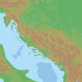
 Herceg Novi map.png 2,514 × 2,548; 1.95 MB
-
 Markovic.jpg 625 × 640; 436 KB
-
 Neretva Map.PNG 641 × 489; 649 KB
-
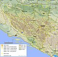
 Relief map of Eastern Bosnia.png 911 × 1,608; 2.4 MB
-
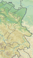
 Reliefkarte Bosnien und Herzegowina.png 2,634 × 2,503; 9.04 MB
-
 Reliefkarte Herzegowina.png 1,078 × 1,252; 1.88 MB
-
 Satellite image of Bosnia and Herzegovina in December 2002.jpg 1,235 × 1,213; 312 KB
-
 Topografija Hrvatske.png 2,000 × 2,000; 153 KB
-
 Tuzla. NYPL1226942.tiff 5,203 × 4,488; 52.26 MB
-
 Zapadna Hercegovina.png 402 × 392; 267 KB
-
 Неум 1.png 410 × 387; 223 KB


