Category:Topographic maps of Florida
States of the United States: Alabama · Alaska · Arizona · Arkansas · California · Colorado · Connecticut · Delaware · Florida · Georgia · Hawaii · Idaho · Illinois · Indiana · Iowa · Kansas · Kentucky · Louisiana · Maine · Maryland · Massachusetts · Michigan · Minnesota · Mississippi · Missouri · Montana · Nebraska · Nevada · New Hampshire · New Jersey · New Mexico · New York · North Carolina · North Dakota · Ohio · Oklahoma · Oregon · Pennsylvania · Rhode Island · South Carolina · South Dakota · Tennessee · Texas · Utah · Vermont · Virginia · Washington · West Virginia · Wisconsin · Wyoming – Washington, D.C.
American Samoa · Puerto Rico · United States Virgin Islands
American Samoa · Puerto Rico · United States Virgin Islands
Subcategories
This category has the following 2 subcategories, out of 2 total.
Media in category "Topographic maps of Florida"
The following 9 files are in this category, out of 9 total.
-
 CapeSableTopo.jpg 600 × 400; 88 KB
-
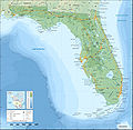 Florida topographic map-en.jpg 2,890 × 2,810; 1.76 MB
-
 Florida topographic map-en.svg 2,890 × 2,810; 2.51 MB
-
 Florida topographic map-fr.jpg 2,890 × 2,810; 1.75 MB
-
 Florida topographic map-fr.svg 2,890 × 2,810; 2.51 MB
-
 Florida topographic map-tr.svg 2,890 × 2,810; 2.5 MB
-
 FT-19 repülőraj.jpg 496 × 360; 96 KB
-
 USA Florida relief location map no Counties borders.jpg 1,132 × 1,096; 201 KB
-
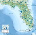
 USA Florida relief location map.jpg 1,132 × 1,096; 213 KB


