Category:Torpoint
town on the Rame Peninsula in southeast Cornwall, United Kingdom  | |||||
| Upload media | |||||
| Instance of | |||||
|---|---|---|---|---|---|
| Location | Cornwall, South West England, England | ||||
| Population |
| ||||
| Said to be the same as | Torpoint (Wikimedia duplicated page, civil parish) | ||||
| official website | |||||
 | |||||
Brezhoneg: Rummad:Kêrioù Breizh-Veur
English: Torpoint is a town in the far south east of Cornwall, England, separated from the city of Plymouth by a stretch of water referred to as the Hamoaze, which itself is the mouth of the River Tamar. It is on the Rame Peninsula.
Kernowek: Penntorr (po Stert yn Kernewek Unyes, Torpoint yn sowsnek) yw tre yn Soth-Est pow Kernow, Breten Veur, a-dreus dowr Tamer a Aberplymm. Yma Penntorr yn deghow a Essa, pur ogas. Yma neb 11 000 a drigoryon (8,633 war-lergh niveryans 2001). Yn plyw Trevanta esa an dre wostalleth.
Norsk bokmål: Torpoint ( kornisk Penntorr) er en by i Cornwall, England. Den ligger på den andre siden av Hamoaze i forhold til Plymouth.
Polski: Torpoint ( korn. Penntorr) - miasto w Wielkiej Brytanii, w Kornwalii. Jest położone na półwyspie Rame, na zachód od Plymouth i oddzielone od niego odnogą delty rzeki Tamar. Z miastem połączone jest promem.
Română: Torpoint ( Limba cornică: Penntorr) este un oraş în comitatul Cornwall, regiunea South West, Anglia.
Subcategories
This category has the following 5 subcategories, out of 5 total.
A
- A-Line Coaches (1 F)
T
- Thanckes oil fuel depot (3 F)
- Torpoint War Memorial (2 F)
W
- Wilcove (42 F)
Media in category "Torpoint"
The following 200 files are in this category, out of 339 total.
(previous page) (next page)-

-

-
 A374 - geograph.org.uk - 5152928.jpg 640 × 426; 66 KB
-
 A374 - geograph.org.uk - 5156050.jpg 640 × 426; 62 KB
-
 A374 - geograph.org.uk - 5174724.jpg 640 × 426; 84 KB
-
 A374 - geograph.org.uk - 5179616.jpg 640 × 426; 84 KB
-
 A374 - geograph.org.uk - 5179655.jpg 640 × 426; 91 KB
-
 A374 - geograph.org.uk - 5179664.jpg 640 × 426; 81 KB
-
 A374 - geograph.org.uk - 5179667.jpg 640 × 426; 67 KB
-
 A374 - geograph.org.uk - 5186509.jpg 640 × 426; 65 KB
-
 Adam Crescent - geograph.org.uk - 5160839.jpg 640 × 426; 88 KB
-
 All aboard - geograph.org.uk - 4620904.jpg 4,000 × 2,664; 2.02 MB
-
 Antony St John Turning - geograph.org.uk - 5783656.jpg 4,260 × 2,075; 857 KB
-
 Antony St John Turning - geograph.org.uk - 5783674.jpg 3,919 × 2,111; 1.15 MB
-
 Antony, UK - panoramio (2).jpg 2,048 × 1,150; 551 KB
-
 Antony, UK - panoramio (3).jpg 2,048 × 1,150; 680 KB
-
 Approaching Torpoint - geograph.org.uk - 5872768.jpg 1,600 × 901; 744 KB
-
 Babcock Marine, Devonport - geograph.org.uk - 5148986.jpg 640 × 417; 46 KB
-
 Boat Trip on the Tamar - geograph.org.uk - 5292804.jpg 3,376 × 2,256; 1.54 MB
-
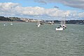
 Boats at Torpoint - geograph.org.uk - 4388365.jpg 1,600 × 1,062; 819 KB
-
 Boats, The Hamoaze - geograph.org.uk - 5149008.jpg 640 × 426; 57 KB
-
 Borough Court - geograph.org.uk - 5160873.jpg 640 × 426; 82 KB
-
 Borough Park - geograph.org.uk - 5160866.jpg 640 × 426; 61 KB
-
 Brent geese, St John's Lake - geograph.org.uk - 5690382.jpg 1,520 × 1,000; 153 KB
-
 Building on Ferry Street - geograph.org.uk - 6295803.jpg 1,024 × 768; 155 KB
-
 Business units, Trevol Business Park - geograph.org.uk - 5785579.jpg 4,288 × 2,848; 2.19 MB
-
 By Penntorr Health - geograph.org.uk - 5793304.jpg 3,623 × 2,178; 737 KB
-
 By St John's Lake - geograph.org.uk - 5664896.jpg 4,288 × 2,848; 1.9 MB
-
 By Trevithick Avenue, Torpoint - geograph.org.uk - 5793258.jpg 4,288 × 2,848; 2.13 MB
-
 Cabbage trees, Torpoint - geograph.org.uk - 5664892.jpg 4,288 × 2,848; 891 KB
-
 Carbeile Inn - geograph.org.uk - 5179688.jpg 640 × 426; 116 KB
-
 Carbeile Inn - geograph.org.uk - 5179699.jpg 640 × 426; 63 KB
-
 Carbeile Rd - geograph.org.uk - 5156102.jpg 640 × 426; 73 KB
-
 Carbeile Rd - geograph.org.uk - 5156112.jpg 640 × 426; 57 KB
-
 Carbeile Rd - geograph.org.uk - 5156127.jpg 640 × 426; 65 KB
-
 Carbeile Rd - geograph.org.uk - 5156130.jpg 640 × 426; 82 KB
-
 Carbeile Rd - geograph.org.uk - 5179708.jpg 640 × 426; 73 KB
-
 Carbeile Road, Torpoint - geograph.org.uk - 4248494.jpg 640 × 480; 79 KB
-
 Carew Wharf - geograph.org.uk - 1827461.jpg 3,600 × 2,700; 1.46 MB
-
 Carew Wharf Business Centre - geograph.org.uk - 5156053.jpg 640 × 426; 59 KB
-
 Cedar Drive - geograph.org.uk - 5160804.jpg 640 × 426; 73 KB
-
 Chapeldown Rd - geograph.org.uk - 5156104.jpg 640 × 426; 89 KB
-
 Chapeldown Rd - geograph.org.uk - 5156148.jpg 640 × 426; 74 KB
-
 Chestnut Close, Torpoint - geograph.org.uk - 5664267.jpg 4,266 × 2,221; 1.23 MB
-
 Children's play area - geograph.org.uk - 5160794.jpg 640 × 426; 72 KB
-
 Church near Horson Cemetery - geograph.org.uk - 4251213.jpg 640 × 480; 101 KB
-
 Church of St James - geograph.org.uk - 5186573.jpg 640 × 426; 64 KB
-
 Church of St James - geograph.org.uk - 5186581.jpg 640 × 426; 70 KB
-
 Clegg Avenue - geograph.org.uk - 5160841.jpg 640 × 426; 77 KB
-
 College playing fields - geograph.org.uk - 5179678.jpg 640 × 426; 70 KB
-
 College playing fields - geograph.org.uk - 5179681.jpg 640 × 426; 91 KB
-
 Control building, Torpoint Ferry - geograph.org.uk - 5152902.jpg 640 × 426; 72 KB
-
 Control Tower, Torpoint Ferry - geograph.org.uk - 5186606.jpg 640 × 426; 70 KB
-
 Corner of Albion Rd - geograph.org.uk - 5186525.jpg 640 × 426; 74 KB
-
 Cornwall , The River Tamar - geograph.org.uk - 5759262.jpg 6,000 × 4,000; 6.03 MB
-
 Cornwall , Torpoint Scenery - geograph.org.uk - 4426475.jpg 4,249 × 2,822; 7.06 MB
-
 Cornwall ACF Torpoint Platoon - geograph.org.uk - 5187944.jpg 640 × 454; 71 KB
-
 Corrugated shed - geograph.org.uk - 5179636.jpg 640 × 426; 128 KB
-
 Cremyll Rd - geograph.org.uk - 5156118.jpg 640 × 427; 59 KB
-
 Cremyll Road, Torpoint - geograph.org.uk - 4248490.jpg 640 × 480; 89 KB
-
 Crop field north of Trevol Road - geograph.org.uk - 4251205.jpg 640 × 480; 105 KB
-
 Depot, Torpoint - geograph.org.uk - 5663858.jpg 3,986 × 2,506; 1.07 MB
-
 Devonport - panoramio.jpg 2,272 × 1,704; 667 KB
-
 Devonport Docks - geograph.org.uk - 5186559.jpg 640 × 426; 61 KB
-

-
 Devonport dockyard Weston Mill - geograph.org.uk - 2596871.jpg 640 × 427; 84 KB
-
 Diction at Carbeille Wharf - geograph.org.uk - 5664854.jpg 3,264 × 1,832; 656 KB
-
 Diction, St Johns Lake - geograph.org.uk - 3412966.jpg 640 × 480; 71 KB
-
 Docks at Devonport, Plymouth - geograph.org.uk - 4388044.jpg 1,600 × 1,062; 658 KB
-
 Docks at Devonport, Plymouth - geograph.org.uk - 4388049.jpg 1,600 × 1,062; 484 KB
-
 Drydock at Devonport, Plymouth - geograph.org.uk - 4388052.jpg 1,600 × 1,062; 462 KB
-
 Ellis Memorial - geograph.org.uk - 3442659.jpg 1,024 × 768; 164 KB
-
 Ellis Monument - geograph.org.uk - 5186552.jpg 426 × 640; 86 KB
-
 Entering Torpoint - geograph.org.uk - 4251215.jpg 640 × 480; 85 KB
-
 Entering Torpoint, A374 - geograph.org.uk - 5179627.jpg 640 × 426; 85 KB
-
 Entering Torpoint, A374 - geograph.org.uk - 5179649.jpg 640 × 426; 105 KB
-
 Enterprise Court - geograph.org.uk - 5156060.jpg 640 × 426; 53 KB
-
 Entrance Lodge, Antony House - geograph.org.uk - 5174719.jpg 640 × 426; 110 KB
-
 Entrance Lodge, Antony House - geograph.org.uk - 5174720.jpg 640 × 426; 89 KB
-
 Entrance to Enterprise Court, Torpoint - geograph.org.uk - 5690407.jpg 4,275 × 2,203; 849 KB
-
 Estuary, St John's Lake - geograph.org.uk - 5664860.jpg 3,264 × 1,832; 681 KB
-
 Farmland near Hay - geograph.org.uk - 4251203.jpg 640 × 480; 53 KB
-
 Ferry St - geograph.org.uk - 5156056.jpg 388 × 640; 48 KB
-
 Ferry Street (A374), Torpoint - geograph.org.uk - 4248524.jpg 640 × 480; 52 KB
-
 Ferry Street, Torpoint - geograph.org.uk - 4248519.jpg 640 × 480; 72 KB
-
 Field by Hay Farm - geograph.org.uk - 5783685.jpg 4,288 × 2,848; 1.94 MB
-
 Field entrance off Goad Avenue - geograph.org.uk - 6203377.jpg 4,288 × 2,848; 2.42 MB
-
 Filling station, Torpoint - geograph.org.uk - 3442660.jpg 1,024 × 768; 141 KB
-
 First bus Torpoint depot October 2004.jpg 1,632 × 1,224; 345 KB
-
 Flats on Harvey Street, Torpoint - geograph.org.uk - 5690491.jpg 2,783 × 1,589; 323 KB
-
 Flats on Marine Drive, Torpoint - geograph.org.uk - 4248496.jpg 640 × 480; 51 KB
-
 Footbridge over small stream - geograph.org.uk - 5160767.jpg 640 × 426; 99 KB
-
 Footbridge, Torpoint Yacht Harbour - geograph.org.uk - 4248507.jpg 640 × 480; 79 KB
-
 Footpath across field - geograph.org.uk - 5174721.jpg 640 × 391; 57 KB
-
 Footpath near Horson Field - geograph.org.uk - 6203383.jpg 2,848 × 4,288; 2.35 MB
-
 Footpath, A374 - geograph.org.uk - 5179660.jpg 640 × 426; 105 KB
-
 Fore St - geograph.org.uk - 5186556.jpg 640 × 426; 71 KB
-
 Fore St, Harvey St junction - geograph.org.uk - 5186549.jpg 640 × 426; 59 KB
-
 Fore Street Post Office - geograph.org.uk - 5186553.jpg 640 × 412; 57 KB
-
 Foreshore at Torpoint - geograph.org.uk - 5690269.jpg 4,288 × 2,848; 1.35 MB
-
 Foreshore, St John's Lake - geograph.org.uk - 5156097.jpg 640 × 426; 81 KB
-
 Foreshore, Torpoint - geograph.org.uk - 4248503.jpg 640 × 480; 51 KB
-
 Former bank, Torpoint - geograph.org.uk - 5690571.jpg 4,288 × 2,848; 940 KB
-
 Garden Restaurant - geograph.org.uk - 5186541.jpg 640 × 426; 63 KB
-
 Gateway to Firleigh House - geograph.org.uk - 5174722.jpg 640 × 426; 103 KB
-
 Goad Avenue - geograph.org.uk - 5160814.jpg 640 × 426; 61 KB
-
 Goad Avenue - geograph.org.uk - 5160831.jpg 640 × 426; 64 KB
-
 Goad Avenue - geograph.org.uk - 5160853.jpg 640 × 426; 76 KB
-
 Goad Avenue - geograph.org.uk - 5160857.jpg 640 × 426; 93 KB
-
 Goad Avenue - geograph.org.uk - 5160875.jpg 640 × 426; 92 KB
-
 Goad Avenue - geograph.org.uk - 6203342.jpg 3,264 × 1,832; 1.5 MB
-
 Goad Avenue joining Trevol Road - geograph.org.uk - 368545.jpg 640 × 426; 85 KB
-
 Goad Avenue, Torpoint - geograph.org.uk - 4248468.jpg 640 × 480; 52 KB
-
 Goad Close - geograph.org.uk - 5160828.jpg 640 × 426; 84 KB
-
 Gravesend Point Torpoint - geograph.org.uk - 359382.jpg 640 × 480; 83 KB
-
 Grove Park - geograph.org.uk - 5160859.jpg 640 × 426; 77 KB
-
 Harbour Office, Torpoint - geograph.org.uk - 5152914.jpg 640 × 426; 74 KB
-
 Harbour offices, Torpoint - geograph.org.uk - 5152915.jpg 640 × 426; 74 KB
-
 Hawthorn Avenue - geograph.org.uk - 5160812.jpg 640 × 426; 72 KB
-
 Hay Farm - geograph.org.uk - 5783644.jpg 4,288 × 2,848; 2.17 MB
-
 HMNB Devenport - geograph.org.uk - 5186597.jpg 640 × 426; 56 KB
-
 HMNB Devonport - geograph.org.uk - 5148990.jpg 640 × 417; 48 KB
-
 HMNB Devonport - geograph.org.uk - 5186565.jpg 640 × 426; 64 KB
-
 HMS Bulwark at Devonport, Plymouth - geograph.org.uk - 4388028.jpg 1,600 × 1,062; 697 KB
-
 HMS Bulwark at Devonport, Plymouth - geograph.org.uk - 4388041.jpg 1,600 × 1,057; 454 KB
-
 HMS Raleigh from the West - geograph.org.uk - 373877.jpg 640 × 426; 105 KB
-
 HMS Torbay at Devonport Dockyard - geograph.org.uk - 5085074.jpg 640 × 480; 62 KB
-
 Horson Cemetery - geograph.org.uk - 5783856.jpg 4,277 × 2,624; 1.74 MB
-
 Horson Cemetery - geograph.org.uk - 6110979.jpg 4,288 × 2,848; 1.73 MB
-
 House, Trevorder Close - geograph.org.uk - 5160782.jpg 640 × 426; 58 KB
-
 Houses on Carbeile Road, Torpoint - geograph.org.uk - 4248487.jpg 640 × 480; 49 KB
-
 Houses on Goad Avenue, Torpoint - geograph.org.uk - 4248466.jpg 640 × 480; 49 KB
-
 Houses on Pencair Avenue, Torpoint - geograph.org.uk - 4248461.jpg 640 × 416; 52 KB
-
 Houses, Trevorder Close - geograph.org.uk - 5160779.jpg 640 × 426; 63 KB
-
 Huggin's Bro's - geograph.org.uk - 5160766.jpg 640 × 426; 57 KB
-
 Jetty, Yonderberry Point - geograph.org.uk - 5186591.jpg 640 × 426; 60 KB
-
 Junction, Torpoint - geograph.org.uk - 5664061.jpg 4,267 × 2,354; 1.06 MB
-
 Junction, Torpoint - geograph.org.uk - 5690443.jpg 4,288 × 2,178; 811 KB
-
 Kernow Close - geograph.org.uk - 5160851.jpg 640 × 426; 78 KB
-
 King's Arms Ferry Street Torpoint - geograph.org.uk - 980333.jpg 640 × 480; 65 KB
-
 Kings Arms - geograph.org.uk - 5152921.jpg 640 × 426; 62 KB
-
 Kings Arms - geograph.org.uk - 5186577.jpg 640 × 426; 64 KB
-
 Kingsley Avenue - geograph.org.uk - 5156121.jpg 640 × 379; 58 KB
-
 Lamorna Park - geograph.org.uk - 5160863.jpg 640 × 407; 74 KB
-
 Landing Apron, Torpoint Ferry - geograph.org.uk - 5152875.jpg 640 × 426; 61 KB
-
 Landing ramp, Torpoint Ferry - geograph.org.uk - 4248537.jpg 640 × 480; 61 KB
-
 Langdondown Way - geograph.org.uk - 5160846.jpg 640 × 426; 76 KB
-
 Lion and Implacable at Devonport, 1897.jpg 437 × 220; 27 KB
-
 Lodge at gateway to Antony House - geograph.org.uk - 3443991.jpg 1,024 × 768; 231 KB
-
 Lynher II, Torpoint Ferry - geograph.org.uk - 5186588.jpg 640 × 426; 74 KB
-
 Lynher II, Torpoint Ferry - geograph.org.uk - 5186601.jpg 640 × 426; 58 KB
-
 Marine Drive - geograph.org.uk - 5156063.jpg 640 × 426; 56 KB
-
 Marine Drive - geograph.org.uk - 5156092.jpg 640 × 403; 64 KB
-
 Mast, Trevol Rd - geograph.org.uk - 5179716.jpg 426 × 640; 80 KB
-
 Milestone, A374 - geograph.org.uk - 5179643.jpg 640 × 426; 109 KB
-
 Mill Lane - geograph.org.uk - 5156134.jpg 640 × 426; 75 KB
-
 Millhouse Park - geograph.org.uk - 5156143.jpg 640 × 426; 67 KB
-
 Millhouse Park, Torpoint - geograph.org.uk - 3413011.jpg 640 × 464; 38 KB
-
 Moor View - geograph.org.uk - 5186538.jpg 640 × 426; 66 KB
-
 Murdock Rd - geograph.org.uk - 5160833.jpg 640 × 426; 72 KB
-
 Naval Vessels, Devonport - geograph.org.uk - 5186629.jpg 640 × 426; 60 KB
-
 Nearing Torpoint - geograph.org.uk - 2149396.jpg 640 × 480; 64 KB
-
 Normal tidal limit on stream, Torpoint - geograph.org.uk - 5664803.jpg 4,288 × 2,848; 2.39 MB
-
 North Rd - geograph.org.uk - 5156124.jpg 640 × 426; 63 KB
-
 Notice, Marine Drive, Torpoint - geograph.org.uk - 5690352.jpg 1,124 × 1,517; 118 KB
-
 Old School House Business Centre, Torpoint - geograph.org.uk - 5690519.jpg 4,261 × 2,700; 944 KB
-
 On Lynher II - geograph.org.uk - 5186614.jpg 640 × 426; 83 KB
-
 Open space, Trevorder Close - geograph.org.uk - 5160781.jpg 640 × 426; 92 KB
-
 Open space, Trevorder Close - geograph.org.uk - 5160783.jpg 640 × 426; 87 KB
-
 Parade Ground - geograph.org.uk - 58025.jpg 640 × 401; 41 KB
-
 Passing Antony House - geograph.org.uk - 2149374.jpg 640 × 480; 79 KB
-
 Path by tidal stream, Torpoint - geograph.org.uk - 5664830.jpg 4,288 × 2,848; 2.16 MB
-
 Pencair Avenue, Torpoint - geograph.org.uk - 4248465.jpg 640 × 480; 88 KB
-
 Pengelly Hill - geograph.org.uk - 5179607.jpg 640 × 426; 109 KB
-
 Ploughed field near Torpoint - geograph.org.uk - 75001.jpg 640 × 480; 96 KB
-
 Plym II - geograph.org.uk - 5148996.jpg 640 × 426; 70 KB
-
 Plym II, Torpoint Ferry - geograph.org.uk - 5186618.jpg 640 × 426; 69 KB
-
 Plym II, Torpoint Ferry - geograph.org.uk - 5186625.jpg 640 × 426; 62 KB
-
 Plymouth , Devonport - HMS Bulwark (L15) - geograph.org.uk - 4614108.jpg 4,288 × 2,848; 5.76 MB
-
 Plymouth , Devonport - Submarine - geograph.org.uk - 4614105.jpg 4,288 × 2,848; 5.76 MB
-
 Plymouth , Die Bonn (A 1413) - geograph.org.uk - 4613706.jpg 4,288 × 2,848; 5.1 MB
-
 Plymouth , Die Bonn (A 1413) - geograph.org.uk - 4613835.jpg 4,288 × 2,848; 6.08 MB
-
 Plymouth , Die Bonn (A 1413) - geograph.org.uk - 4613836.jpg 4,288 × 2,848; 5.61 MB
-
 Plymouth , Die Bonn (A 1413) - geograph.org.uk - 4615094.jpg 4,288 × 2,848; 5.25 MB
-
 Plymouth , Die Bonn (A 1413) - Helicopter - geograph.org.uk - 4615095.jpg 4,288 × 2,848; 7.67 MB
-
 Plymouth , HMNB Devonport - geograph.org.uk - 5756592.jpg 6,000 × 4,000; 6.03 MB
-
 Plymouth , HMNB Devonport - geograph.org.uk - 5759263.jpg 6,000 × 4,000; 5.25 MB
-
 Plymouth , HMNB Devonport - HMS Dragon (D35) - geograph.org.uk - 5756593.jpg 6,000 × 4,000; 5.84 MB
-
 Plymouth , HMNB Devonport - HMS Dragon (D35) - geograph.org.uk - 5756594.jpg 6,000 × 4,000; 5.86 MB
-
 Plymouth , Shipwreck - geograph.org.uk - 1140362.jpg 640 × 512; 36 KB
-
 Plymouth , Shipwreck in the Hamoaze - geograph.org.uk - 1151498.jpg 640 × 480; 55 KB
-
 Plymouth , The Hamoaze - geograph.org.uk - 5360360.jpg 6,000 × 4,000; 6.4 MB
-
 Plymouth , The Hamoaze - geograph.org.uk - 5360376.jpg 6,000 × 4,000; 7.07 MB
-
 Plymouth , Torpoint Scenery - geograph.org.uk - 5360378.jpg 6,000 × 4,000; 6.64 MB
-
 Plymouth , Yonderberry Fuel Jetty - geograph.org.uk - 1151481.jpg 640 × 480; 68 KB
-
 Postbox, Torpoint - geograph.org.uk - 5664881.jpg 4,288 × 2,848; 1.14 MB
-
 Postbox, Torpoint - geograph.org.uk - 5664882.jpg 2,848 × 4,288; 1.75 MB
-
 Quarry Street, Torpoint - geograph.org.uk - 2633418.jpg 563 × 640; 71 KB
-
 Queueing area, Torpoint Ferry - geograph.org.uk - 5186583.jpg 640 × 426; 69 KB
-
 Radio Mast at Thanckes Fuel Depot - geograph.org.uk - 2336013.jpg 3,648 × 2,736; 4.66 MB


.jpg)
.jpg)


,_Torpoint_-_geograph.org.uk_-_4248524.jpg)


_-_geograph.org.uk_-_4614108.jpg)

_-_geograph.org.uk_-_4613706.jpg)
_-_geograph.org.uk_-_4613835.jpg)
_-_geograph.org.uk_-_4613836.jpg)
_-_geograph.org.uk_-_4615094.jpg)
_-_Helicopter_-_geograph.org.uk_-_4615095.jpg)


_-_geograph.org.uk_-_5756593.jpg)
_-_geograph.org.uk_-_5756594.jpg)


