Category:Toutle River
tributary to the Cowlitz River in Cowlitz County, Washington state, United States of America  | |||||
| Upload media | |||||
| Instance of | |||||
|---|---|---|---|---|---|
| Located in protected area |
| ||||
| Location |
| ||||
| Length |
| ||||
| Elevation above sea level |
| ||||
| Mouth of the watercourse | |||||
| Drainage basin | |||||
| Tributary |
| ||||
 | |||||
English: The Toutle River — a 17.2-mile (27.7 km) tributary of the Cowlitz River, in Cowlitz County, southwestern Washington state.
- The Toutle River begins at the confluence of the North Fork Toutle River and the South Fork Toutle River, which both originate on Mount St. Helens within Mount St. Helens National Volcanic Monument.
Subcategories
This category has the following 2 subcategories, out of 2 total.
H
- Harry Gardner Park (6 F)
T
Media in category "Toutle River"
The following 26 files are in this category, out of 26 total.
-
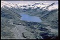 Castle Creek and Castle Lake, Washington.jpg 3,072 × 2,048; 3.96 MB
-
 Cowlitz - 2.png 520 × 403; 84 KB
-
 Debri flow (coldwater Lake) panorama.jpg 9,124 × 1,832; 5.21 MB
-
 Debri flow 3362.jpg 4,608 × 2,592; 3.15 MB
-
 Dredging Toutle River.jpg 800 × 500; 93 KB
-
 Hoffstadt Creek Bridge 3396.jpg 4,608 × 3,072; 3.12 MB
-
 Kid Valley bridge on SR 504, July 1980.jpg 3,483 × 2,329; 6.74 MB
-
 Lahar field 3393.jpg 4,608 × 3,072; 3.7 MB
-
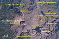
 MSHtoutleareaedit.jpg 6,342 × 3,576; 17.8 MB
-
 Mt St Helens Windy Ridge 2017 08.jpg 5,184 × 3,456; 7.67 MB
-
 Mt St Helens Windy Ridge 2017 25.jpg 5,184 × 3,456; 7 MB
-
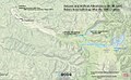 Mt. Saint Helens post-eruption hydrology alterations.jpg 1,453 × 892; 547 KB
-
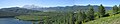
 North Fork Toutle River (3960341161).jpg 2,048 × 1,536; 1.7 MB
-
 North Fork Toutle River valley in November 1983.jpg 2,913 × 1,977; 2.51 MB
-
 St Helens and nearby area from space.jpg 692 × 465; 270 KB
-
 Toutle River Bridge Destruction After Mt. St. Helens Eruption-1.jpg 2,780 × 2,024; 2.74 MB
-
 Toutle River Bridge Destruction After Mt. St. Helens Eruption-2.jpg 2,688 × 1,808; 3.95 MB
-
 Toutle River in flood.jpg 1,500 × 991; 1.14 MB
-
 Toutle valley 3403.jpg 4,608 × 3,072; 2.92 MB
-
 Uppr Viewpt (west) 8935.jpg 6,000 × 4,000; 9.74 MB
-
 Uppr Viewpt (west) 8943.jpg 6,000 × 4,000; 7.04 MB
-
 Uppr Viewpt (west) 8944.jpg 6,000 × 4,000; 11 MB
-
 USACE sediment retention structure Toutle River.jpg 1,500 × 1,030; 649 KB
-
 Volcano 3394.jpg 4,608 × 3,072; 3.5 MB
-
 WA 504 3398.jpg 4,608 × 3,072; 2.76 MB
-
 WA 504 3399.jpg 4,608 × 3,072; 3.94 MB


.jpg)


_8935.jpg)
_8943.jpg)
_8944.jpg)


_panorama.jpg)