Category:Town Hall in Makó
| Object location | | View all coordinates using: OpenStreetMap |
|---|
former hall of Csanád County | |||||
| Upload media | |||||
| Instance of | |||||
|---|---|---|---|---|---|
| Location | Makó, Makó District, Csongrád-Csanád County, Hungary | ||||
 | |||||
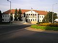
English: Csanád County Hall
Magyar: A makói városháza, az egykori Csanád vármegye háza. Műemlék azonosító: 3417. Az 1780-ban Vertics József által tervezett földszintes megyeházát 1834-1836 között Giba Antal tervei szerint megnövelték klasszicista stílusban; az emeletes, oszlopos középrizalitú épület. - Csongrád m., Makó, Széchenyi tér 22., Megyeház u
English: The Town Hall in Makó, the building was the County Hall of the former county Csanád. - Széchenyi square 22., Megyeház street
Deutsch: Das Rathaus in Makó, Ungarn. Das Gebäude war Sitz des ehemaligen Landkreises Csanád.
Română: Consiliul Local din Makó, Ungaria. Clădirea a fost sediul fostului judeţ Csanád.
|
This is a category about a monument in Hungary. Identifier: 3417 |
Subcategories
This category has only the following subcategory.
Media in category "Town Hall in Makó"
The following 24 files are in this category, out of 24 total.
-
 Az egykori Megyeháza, ma a városi önkormányzat épülete. Fortepan 15050.jpg 2,864 × 2,657; 4.05 MB
-
 Makó 1951, Városháza. Fortepan 15051.jpg 2,679 × 2,196; 3.2 MB
-

-
 Széchenyi tér, háttérben takarva az egykori Megyeháza (ma Városháza). Fortepan 15074.jpg 2,955 × 2,015; 3.23 MB
-
 Városháza (Megyeháza). Fortepan 15083.jpg 2,910 × 3,027; 4.54 MB
-
 Városháza (Megyeháza). Fortepan 15084.jpg 2,946 × 2,684; 4.31 MB
-
 Városháza (Megyeháza). Fortepan 15085.jpg 2,910 × 3,054; 4.54 MB
-
 Gedenktafel (1999), Rathaus, 2023 Makó.jpg 1,553 × 1,037; 262 KB
-
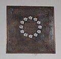 Gedenktafel Entente Florale Europe, Rathaus, 2023 Makó.jpg 1,448 × 1,404; 577 KB
-
 Gedenktafel István Marczibányi, Rathaus, 2023 Makó.jpg 1,833 × 1,234; 564 KB
-
 Kossuth Mako.JPG 892 × 1,246; 401 KB
-
 Lajos Kossuth von Udvard und Kossuthfalva (Ede Kallós), Rathaus, 2023 Makó.jpg 2,203 × 1,419; 660 KB
-
 Lajos Návay von Földeák Denkmal, 2023 Makó.jpg 2,272 × 1,704; 966 KB
-
 Makó town hall summer.JPG 2,304 × 1,728; 793 KB
-
 Makói megyeháza 0155597.jpg 1,273 × 820; 699 KB
-
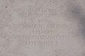
 Memorial tablet Marczibányi István.JPG 2,304 × 1,728; 896 KB
-
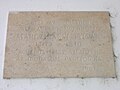
 Memorial tablet Resettlement.JPG 2,304 × 1,728; 921 KB
-
 Rathaus Mako.JPG 1,280 × 960; 404 KB
-
 Rathaus, 2023 Makó.jpg 2,195 × 1,645; 858 KB
-
 Rathaus, Mitte, 2023 Makó.jpg 1,704 × 2,272; 1.08 MB
-
 Rathaus, W, 2023 Makó.jpg 2,272 × 1,704; 1,016 KB
-
 Rathaus, Úristrasse, 2023 Makó.jpg 2,272 × 1,704; 1,004 KB
-
 TownHall Makó.JPG 2,304 × 1,728; 823 KB
-
 Wappen Mako.JPG 798 × 730; 187 KB


_oszlopsoros_%C3%A9p%C3%BClete._Fortepan_15053.jpg)
._Fortepan_15074.jpg)
._Fortepan_15083.jpg)
._Fortepan_15084.jpg)
._Fortepan_15085.jpg)
,_Rathaus,_2023_Mak%C3%B3.jpg)


,_Rathaus,_2023_Mak%C3%B3.jpg)


