Category:Trewen
village and civil parish near Launceston, in Cornwall, England, UK  Eglwys San Mihangel a'r Holl Anghylion, Trewen | |||||
| Upload media | |||||
| Instance of | |||||
|---|---|---|---|---|---|
| Location | Cornwall, South West England, England | ||||
 | |||||
English: Trewen is a hamlet and a civil parish in east Cornwall, United Kingdom. The parish is just east of Bodmin Moor in the valley of the Inney and lies in the Registration District of Launceston.

Subcategories
This category has only the following subcategory.
Media in category "Trewen"
The following 46 files are in this category, out of 46 total.
-
 A395 entering Pipers Pool from the west - geograph.org.uk - 6261669.jpg 1,600 × 1,202; 892 KB
-
 A395 junction with road for Trenault - geograph.org.uk - 5766978.jpg 1,600 × 799; 532 KB
-
 Bridge over River Inny at Trewen Mill (geograph 5765762).jpg 1,600 × 1,200; 880 KB
-
 Bungalows at the south of Pipers Pool - geograph.org.uk - 5765771.jpg 1,600 × 1,066; 730 KB
-
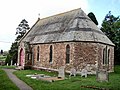
 Church of St Michael, Trewen - geograph.org.uk - 4436726.jpg 1,920 × 1,147; 337 KB
-
 Communications mast and wind turbine by A395 - geograph.org.uk - 5767002.jpg 1,600 × 1,069; 727 KB
-
 Entering Pipers Pool - geograph.org.uk - 3527201.jpg 1,024 × 768; 242 KB
-
 Field north of Trenault - geograph.org.uk - 4436374.jpg 1,920 × 1,495; 541 KB
-
 Field of buttercups - geograph.org.uk - 437302.jpg 640 × 242; 44 KB
-
 Footpath to Hicks Mill - geograph.org.uk - 4436161.jpg 1,920 × 1,440; 898 KB
-
 House in Pipers Pool by A395 - geograph.org.uk - 5766964.jpg 1,600 × 1,200; 818 KB
-
 Junction at Pipers Pool - geograph.org.uk - 4436577.jpg 1,920 × 1,209; 407 KB
-
 Junction, Trewen - geograph.org.uk - 4436704.jpg 1,920 × 1,440; 671 KB
-
 Lane north of Trenault - geograph.org.uk - 4430803.jpg 1,920 × 1,440; 1.07 MB
-
 Lane to Trenault - geograph.org.uk - 4436165.jpg 1,920 × 2,228; 637 KB
-
 Lodge Plantation by A395 - geograph.org.uk - 6261660.jpg 1,600 × 1,200; 1,007 KB
-
 New wind turbines near Menwenicke Barton - geograph.org.uk - 3527174.jpg 1,024 × 768; 188 KB
-
 Old Boundary Marker (geograph 6429225).jpg 580 × 772; 195 KB
-
 Old Milestone by the A395, Pipers Pool - geograph.org.uk - 5623341.jpg 640 × 430; 128 KB
-
 Piper's Pool from the A395 on the west - geograph.org.uk - 4185865.jpg 1,600 × 1,202; 1.31 MB
-
 Pipers Pool - geograph.org.uk - 437307.jpg 640 × 480; 83 KB
-
 Pipers Pool - geograph.org.uk - 699985.jpg 640 × 411; 53 KB
-
 Pipers Pool Methodist Chapel - geograph.org.uk - 437310.jpg 640 × 480; 112 KB
-
 Pipers Pool Methodist Church - geograph.org.uk - 4430823.jpg 1,920 × 1,265; 589 KB
-
 River Inny at Trewen Mill - geograph.org.uk - 4700785.jpg 1,920 × 1,440; 1.13 MB
-
 Road junction at Pipers Pool - geograph.org.uk - 3435543.jpg 783 × 587; 124 KB
-
 Road junction in Trewen - geograph.org.uk - 5765767.jpg 1,600 × 1,199; 665 KB
-
 The A395 at Coombegate - geograph.org.uk - 3527229.jpg 1,024 × 768; 232 KB
-
 The A395 at Pipers Pool - geograph.org.uk - 3527206.jpg 1,024 × 768; 252 KB
-
 The A395 at Pipers Pool - geograph.org.uk - 3527215.jpg 1,024 × 768; 261 KB
-
 The A395 towards Pipers Pool - geograph.org.uk - 3527175.jpg 1,024 × 768; 218 KB
-
 The A395 west of Pipers Pool - geograph.org.uk - 3527220.jpg 1,024 × 768; 280 KB
-
 The road to Gospenheale from Pipers Pool - geograph.org.uk - 5766971.jpg 1,600 × 1,066; 638 KB
-
 The small settlement of Pipers Pool - geograph.org.uk - 2016106.jpg 640 × 484; 81 KB
-
 Towards Pipers Pool - geograph.org.uk - 4436514.jpg 1,920 × 1,181; 665 KB
-
 Track near Pipers Pool - geograph.org.uk - 4431000.jpg 1,920 × 1,323; 765 KB
-
 Track through Lodge Plantation - geograph.org.uk - 6261663.jpg 1,600 × 1,200; 1,004 KB
-
 Track, Trenault - geograph.org.uk - 4436175.jpg 1,920 × 1,251; 560 KB
-
 Trees along field boundary, Trenault - geograph.org.uk - 4436380.jpg 1,920 × 2,357; 878 KB
-
 Trewen Mill - geograph.org.uk - 4436749.jpg 2,145 × 1,540; 592 KB
-
 Trewen Mill - geograph.org.uk - 5511994.jpg 1,600 × 1,200; 488 KB
-
 Trewen Mill - geograph.org.uk - 5765763.jpg 1,600 × 1,200; 832 KB
-
 Wind-shaped tree by A395 near Pipers Pool - geograph.org.uk - 5766985.jpg 1,600 × 798; 549 KB
-
 Heathland, Laneast Downs - geograph.org.uk - 699974.jpg 640 × 480; 114 KB
-
 Laneast, Gimblett's Mill - geograph.org.uk - 47897.jpg 640 × 428; 162 KB
-
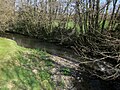
 Trees following parish boundary - geograph.org.uk - 637647.jpg 640 × 480; 81 KB


.jpg)


.jpg)


