Category:U.S. Route 52 in North Carolina
States of the United States: Illinois · Indiana · Iowa · Kentucky · Minnesota · North Carolina · North Dakota · Ohio · South Carolina · Virginia · West Virginia
section of U.S. Numbered Highway in North Carolina, United States  | |||||
| Upload media | |||||
| Instance of | |||||
|---|---|---|---|---|---|
| Location | North Carolina | ||||
| Transport network | |||||
| Owned by | |||||
| Maintained by | |||||
| Inception |
| ||||
| Length |
| ||||
| |||||
English: Media related to U.S. Route 52 in North Carolina, a section of U.S. Highway in North Carolina, United States.
Subcategories
This category has only the following subcategory.
Y
Media in category "U.S. Route 52 in North Carolina"
The following 36 files are in this category, out of 36 total.
-
 Aerial US52-LibertySt 01.jpg 3,008 × 2,000; 3.82 MB
-
 Aerial US52-LibertySt 02.jpg 3,008 × 2,000; 4.21 MB
-
 BL-40 East - US52 Detour Sign (29640743528).jpg 2,400 × 1,600; 2.38 MB
-
 Clouds above US 52 NC 8.jpg 5,212 × 4,000; 2.14 MB
-
 Exit 10 SB on U.S. Route 52.jpg 6,000 × 2,202; 1.76 MB
-
 Exit 108 WB on US 52.jpg 5,463 × 1,885; 1.76 MB
-
 Exits 6 at Westbound I-40 Business in Winston-Salem, NC.jpg 1,600 × 1,200; 378 KB
-
 I-85 South - Exit 76 - US52 South (49202217302).jpg 3,600 × 2,400; 3.2 MB
-
 I-85 South - Exit 84 - US29 US70 (49202216787).jpg 3,600 × 2,400; 3.15 MB
-
 I-85 South - MM86 (49202009316).jpg 3,600 × 2,400; 3.37 MB
-
 I-85 South US52 Signs - MM84 (49202009791).jpg 3,600 × 2,400; 2.93 MB
-
 I-85 US29 US52 South US70 West Signs (49201522328).jpg 3,600 × 2,400; 3.16 MB
-
 Interstate 85 in North Carolina (26484414697).jpg 4,608 × 3,456; 7.46 MB
-
 Interstate 85 in North Carolina (26484418477).jpg 4,608 × 3,456; 7.26 MB
-
 Interstate 85 in North Carolina (26484424757).jpg 4,608 × 3,456; 7.38 MB
-
 Interstate 85 in North Carolina (27484079858).jpg 4,608 × 3,456; 7.68 MB
-
 Interstate 85 in North Carolina (27484081738).jpg 4,608 × 3,456; 7.74 MB
-
 Interstate 85 in North Carolina (27484084858).jpg 4,608 × 3,456; 7.73 MB
-
 Interstate 85 in North Carolina (40459991815).jpg 4,608 × 3,456; 7.56 MB
-
 Interstate 85 in North Carolina (40641405384).jpg 4,608 × 3,456; 7.28 MB
-
 NC742 NC109 US52 US74 Wadesboro.jpg 5,520 × 3,684; 5.79 MB
-
 NC8-NC73-End New London.jpg 3,684 × 5,520; 8.1 MB
-
 New N.C. 150 Interchange in Davidson County.jpg 3,456 × 2,304; 4.72 MB
-
 Pilot Mountain US-52 in NC 071102.JPG 2,592 × 1,023; 1.02 MB
-
 Powerlines over US 52 NC 8.jpg 5,486 × 3,160; 1.28 MB
-
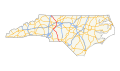 US 52 in North Carolina map.svg 1,205 × 709; 178 KB
-
 US 52 North Carolina 1926.svg 1,485 × 1,440; 32 KB
-
 US 52A North Carolina 1950.svg 1,485 × 1,440; 31 KB
-
 US52 NC742 South Signs (49202233237).jpg 3,600 × 2,400; 2.91 MB
-
 US52 NC742 South US74 East Signs (49202026406).jpg 3,600 × 2,400; 3.21 MB
-
 US52 US74 Wadesboro NC.jpg 3,684 × 5,520; 4.18 MB
-
 US74 East NC742 US52 South at NC109 Signs (49201539908).jpg 3,600 × 2,400; 3.09 MB
-
 US74 East US52 South Signs (49201540198).jpg 3,600 × 2,400; 3.22 MB
-
 Winston-Salem Skyline seen from US 52 NC 8 2.jpg 5,999 × 2,215; 1.76 MB
-
 Winston-Salem Skyline seen from US 52 NC 8 3.jpg 5,999 × 2,013; 1.44 MB
-
 Winston-Salem Skyline seen from US 52 NC 8.jpg 5,999 × 2,102; 1.6 MB


.jpg)


.jpg)
.jpg)
.jpg)
.jpg)
.jpg)
.jpg)
.jpg)
.jpg)
.jpg)
.jpg)
.jpg)
.jpg)
.jpg)


.jpg)
.jpg)

.jpg)
.jpg)