Category:US National Archives series: Digital Photographs Relating to America's Byways - California
Media in category "US National Archives series: Digital Photographs Relating to America's Byways - California"
The following 182 files are in this category, out of 182 total.
-

-

-

-
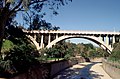
 Arroyo Seco Historic Parkway - Route 117 - The Cut Opening Day, 1940 - NARA - 7717018.jpg 3,622 × 2,419; 7.34 MB
-

-

-

-
 Arroyo Seco Historic Parkway - Route 121 - Arroyo Drive Above Parkway - NARA - 7717019.jpg 3,610 × 2,377; 8.78 MB
-
 Arroyo Seco Historic Parkway - Route 122 - York Street Bridge - NARA - 7717015.jpg 3,622 × 2,383; 7.89 MB
-

-

-

-
-

-
 Arroyo Seco Historic Parkway - Route 130 - Gamble House, Pasadena - NARA - 7717021.jpg 3,616 × 2,413; 7.02 MB
-
-
 Death Valley Scenic Byway - Aguereberry Point - NARA - 7717896.jpg 1,200 × 900; 829 KB
-

-
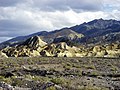
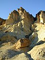
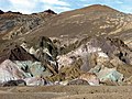 Death Valley Scenic Byway - Artist's Palette - NARA - 7717899.jpg 900 × 675; 237 KB
-
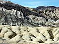
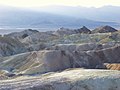
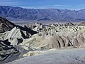 Death Valley Scenic Byway - Badlands and Gower Gulch - NARA - 7717900.jpg 1,024 × 768; 165 KB
-

-
 Death Valley Scenic Byway - Badlands Wash - NARA - 7717903.jpg 1,024 × 768; 508 KB
-
 Death Valley Scenic Byway - Beavertail Cactus - NARA - 7717907.jpg 1,024 × 768; 241 KB
-
 Death Valley Scenic Byway - Brush in Sand Dunes - NARA - 7717952.jpg 960 × 1,280; 206 KB
-
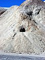
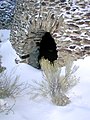 Death Valley Scenic Byway - Charcoal Kiln in Snow - NARA - 7717911.jpg 900 × 1,200; 985 KB
-
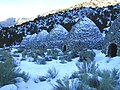 Death Valley Scenic Byway - Charcoal Kilns in Death Valley - NARA - 7717912.jpg 1,200 × 900; 1.13 MB
-
 Death Valley Scenic Byway - Cholla Cactus - NARA - 7717913.jpg 1,024 × 768; 142 KB
-
 Death Valley Scenic Byway - Choppy Shores of Badwater Spring - NARA - 7717906.jpg 2,048 × 1,536; 1.9 MB
-
 Death Valley Scenic Byway - Cottonball Basin - NARA - 7717914.jpg 980 × 750; 763 KB
-

-
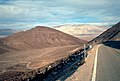
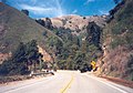
 Death Valley Scenic Byway - Dante's View Road - NARA - 7717979.jpg 1,024 × 768; 156 KB
-
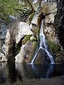
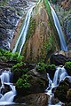
 Death Valley Scenic Byway - Darwin Falls - NARA - 7717920.jpg 1,024 × 1,520; 424 KB
-
 Death Valley Scenic Byway - Darwin Falls From Above - NARA - 7717922.jpg 916 × 1,200; 1.12 MB
-
 Death Valley Scenic Byway - Darwin Falls in the Panamint Region - NARA - 7717921.jpg 900 × 1,200; 1.11 MB
-
 Death Valley Scenic Byway - Dried Up Lakeshore in Badwater - NARA - 7717897.jpg 2,048 × 1,536; 2.02 MB
-
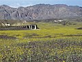 Death Valley Scenic Byway - Fields of Desert Gold - NARA - 7717923.jpg 1,024 × 768; 170 KB
-

-
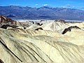
 Death Valley Scenic Byway - Furnace Creek Badlands - NARA - 7717895.jpg 1,200 × 900; 1.07 MB
-
 Death Valley Scenic Byway - Furnace Creek Badlands - NARA - 7717928.jpg 1,024 × 768; 188 KB
-
 Death Valley Scenic Byway - Furnace Creek Badlands - NARA - 7717929.jpg 1,024 × 768; 176 KB
-
 Death Valley Scenic Byway - Furnace Creek Badlands - NARA - 7717930.jpg 1,024 × 768; 428 KB
-
 Death Valley Scenic Byway - Furnace Creek Badlands - NARA - 7717931.jpg 1,024 × 768; 165 KB
-
 Death Valley Scenic Byway - Furnace Creek Badlands - NARA - 7717932.jpg 1,024 × 768; 151 KB
-
 Death Valley Scenic Byway - Furnace Creek Cut - NARA - 7717933.jpg 1,024 × 768; 190 KB
-
 Death Valley Scenic Byway - Furnace Creek Wash - NARA - 7717927.jpg 1,024 × 768; 527 KB
-
 Death Valley Scenic Byway - Golden Canyon - NARA - 7717935.jpg 1,200 × 1,008; 1.06 MB
-
 Death Valley Scenic Byway - Golden Canyon in Death Valley - NARA - 7717936.jpg 900 × 1,200; 1.01 MB
-
 Death Valley Scenic Byway - Gower Gulch - NARA - 7717937.jpg 1,024 × 768; 121 KB
-
 Death Valley Scenic Byway - Harmony Borax Works - NARA - 7717938.jpg 1,024 × 768; 535 KB
-
 Death Valley Scenic Byway - Harmony Borax Works - NARA - 7717939.jpg 1,024 × 768; 514 KB
-
 Death Valley Scenic Byway - Indian Paintbrush - NARA - 7717959.jpg 768 × 1,024; 203 KB
-

-

-
 Death Valley Scenic Byway - Leadfield Dugout - NARA - 7717941.jpg 1,024 × 768; 230 KB
-

-
 Death Valley Scenic Byway - Lower Furnace Creek Wash - NARA - 7717942.jpg 1,024 × 768; 179 KB
-
 Death Valley Scenic Byway - Manly Beacon - NARA - 7717943.jpg 1,024 × 768; 535 KB
-
 Death Valley Scenic Byway - Manly Beacon - NARA - 7717945.jpg 1,024 × 768; 166 KB
-
 Death Valley Scenic Byway - Manly Beacon - NARA - 7717969.jpg 1,024 × 768; 501 KB
-
 Death Valley Scenic Byway - Manly Beacon - NARA - 7717974.jpg 1,024 × 768; 432 KB
-
 Death Valley Scenic Byway - Manly Beacon at Golden Canyon - NARA - 7717944.jpg 850 × 1,200; 902 KB
-

-
 Death Valley Scenic Byway - Mariposa Blossom - NARA - 7717924.jpg 1,024 × 768; 188 KB
-
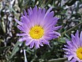 Death Valley Scenic Byway - Mojave Aster - NARA - 7717947.jpg 1,024 × 768; 87 KB
-
 Death Valley Scenic Byway - Mouth of Mosaic Canyon - NARA - 7717909.jpg 1,024 × 768; 552 KB
-
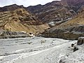
 Death Valley Scenic Byway - Panamint Valley - NARA - 7717986.jpg 3,610 × 2,431; 9.96 MB
-
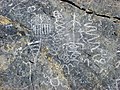 Death Valley Scenic Byway - Petroglyphs at Klare Spring - NARA - 7717961.jpg 1,024 × 768; 260 KB
-
 Death Valley Scenic Byway - Rainbow Canyon and the Argus Mountains - NARA - 7717984.jpg 3,608 × 2,409; 9.57 MB
-
 Death Valley Scenic Byway - Red Cathedral - NARA - 7717971.jpg 1,024 × 768; 519 KB
-

-

-
 Death Valley Scenic Byway - Red Cathedral in Death Valley - NARA - 7717977.jpg 1,200 × 900; 1.13 MB
-

-
 Death Valley Scenic Byway - Reflections in Badwater Pool - NARA - 7717905.jpg 1,024 × 768; 160 KB
-

-
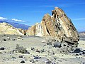
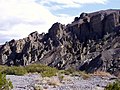
 Death Valley Scenic Byway - Rock Layers of Mosaic Canyon - NARA - 7717981.jpg 1,024 × 768; 685 KB
-
 Death Valley Scenic Byway - Rock Mosaic at Mosaic Canyon - NARA - 7717982.jpg 1,024 × 768; 646 KB
-
 Death Valley Scenic Byway - Rogers, Bennet, and Telescope Peaks - NARA - 7717983.jpg 1,200 × 832; 1.01 MB
-
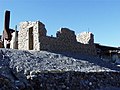
 Death Valley Scenic Byway - Scotty's Castle - NARA - 7717910.jpg 768 × 1,024; 133 KB
-
 Death Valley Scenic Byway - Scotty's Castle Gate - NARA - 7717968.jpg 1,024 × 768; 227 KB
-
 Death Valley Scenic Byway - Scotty's Castle Museum - NARA - 7717989.jpg 768 × 1,024; 157 KB
-
 Death Valley Scenic Byway - Scotty's Castle Museum - NARA - 7717990.jpg 980 × 750; 170 KB
-
 Death Valley Scenic Byway - Scotty's Castle Museum - NARA - 7717991.jpg 1,024 × 768; 166 KB
-

-

-

-

-
 Death Valley Scenic Byway - Teakettle Junction in Death Valley - NARA - 7717993.jpg 2,207 × 1,485; 594 KB
-
 Death Valley Scenic Byway - Telescope Peak - NARA - 7717995.jpg 1,024 × 768; 182 KB
-

-
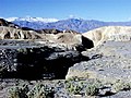
 Death Valley Scenic Byway - The Badlands in Death Valley - NARA - 7717901.jpg 1,024 × 768; 127 KB
-
 Death Valley Scenic Byway - The Death Valley Sand Dunes - NARA - 7717894.jpg 2,028 × 1,358; 593 KB
-
 Death Valley Scenic Byway - The Death Valley Sand Dunes - NARA - 7717953.jpg 1,280 × 960; 492 KB
-
 Death Valley Scenic Byway - The Harmony Borax Works - NARA - 7717940.jpg 1,024 × 768; 571 KB
-
 Death Valley Scenic Byway - The Narrows at Mosaic Canyon - NARA - 7717949.jpg 1,024 × 768; 527 KB
-
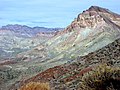
 Death Valley Scenic Byway - The Panamint Mountains - NARA - 7717960.jpg 2,048 × 1,536; 2.04 MB
-
 Death Valley Scenic Byway - The Salt Flats - NARA - 7717988.jpg 900 × 1,200; 1.1 MB
-
 Death Valley Scenic Byway - The Salt Flats of Death Valley - NARA - 7717987.jpg 1,200 × 900; 1.3 MB
-
 Death Valley Scenic Byway - The Sand Dunes of Death Valley - NARA - 7717893.jpg 1,367 × 2,028; 959 KB
-
 Death Valley Scenic Byway - The Ubehebe Crator - NARA - 7718000.jpg 1,024 × 693; 988 KB
-
 Death Valley Scenic Byway - Thimble Peak - NARA - 7717996.jpg 1,024 × 768; 194 KB
-
 Death Valley Scenic Byway - Titus Canyon - NARA - 7717997.jpg 1,024 × 768; 218 KB
-

-
 Death Valley Scenic Byway - Ubehebe Crater - NARA - 7717999.jpg 1,024 × 678; 930 KB
-
 Death Valley Scenic Byway - Upper Mosaic Canyon - NARA - 7718001.jpg 1,024 × 768; 557 KB
-
 Death Valley Scenic Byway - View from Father Crowley Point - NARA - 7717985.jpg 3,624 × 2,425; 9.95 MB
-
 Death Valley Scenic Byway - View from Red Pass - NARA - 7718002.jpg 1,024 × 768; 213 KB
-
 Death Valley Scenic Byway - View of Badwater from Dante's View - NARA - 7717916.jpg 1,200 × 900; 1.02 MB
-
 Death Valley Scenic Byway - View of the Valley - NARA - 7717919.jpg 1,024 × 768; 174 KB
-
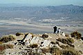
 Death Valley Scenic Byway - Visitor to Racetrack Playa - NARA - 7717976.jpg 1,024 × 748; 711 KB
-
-
 Death Valley Scenic Byway - Water on the Salt Flats of Death Valley - NARA - 7717956.jpg 2,048 × 1,536; 250 KB
-
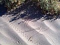 Death Valley Scenic Byway - Wildlife Tracks in Sand Dunes - NARA - 7717951.jpg 1,280 × 960; 271 KB
-
 Ebbetts Pass Scenic Byway - Carving through Powder - NARA - 7718123.jpg 2,946 × 1,954; 3.2 MB
-
 Ebbetts Pass Scenic Byway - Catching Air - NARA - 7718120.jpg 2,016 × 1,344; 887 KB
-
 Ebbetts Pass Scenic Byway - Downhill Skiing - NARA - 7718122.jpg 3,000 × 1,984; 2.26 MB
-
 Ebbetts Pass Scenic Byway - Dropping off a Cliff - NARA - 7718118.jpg 2,048 × 3,072; 1.67 MB
-

-
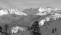 Ebbetts Pass Scenic Byway - Mountain Peaks of Bear Valley - NARA - 7718116.jpg 1,803 × 1,032; 923 KB
-

-
 Ebbetts Pass Scenic Byway - Powder Run at Bear Valley - NARA - 7718117.jpg 2,844 × 1,896; 3.43 MB
-
 Ebbetts Pass Scenic Byway - Riding off a Cliff - NARA - 7718121.jpg 1,440 × 2,160; 1.02 MB
-
 Ebbetts Pass Scenic Byway - Ski Tracks - NARA - 7718124.jpg 1,500 × 2,282; 1.22 MB
-

-
 Ebbetts Pass Scenic Byway - Two Young Cross-Country Skiiers - NARA - 7718115.jpg 2,000 × 3,008; 2.21 MB
-
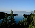 Lake Tahoe - Eastshore Drive - Emerald Bay - NARA - 7719898.jpg 2,401 × 1,920; 440 KB
-
 Route 1 - Big Sur Coast Highway - A Cloudy Seaside View - NARA - 7721409.jpg 1,632 × 1,232; 621 KB
-
 Route 1 - Big Sur Coast Highway - Andrew Molera State Park - NARA - 7721410.jpg 3,264 × 2,448; 5.73 MB
-

-
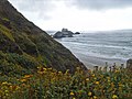
 Route 1 - Big Sur Coast Highway - Big Sur Coastline Cliffs - NARA - 7721421.jpg 3,264 × 2,448; 3.86 MB
-

-

-
 Route 1 - Big Sur Coast Highway - Hurricane Point - NARA - 7721414.jpg 3,264 × 2,448; 3.21 MB
-

-
 Route 1 - Big Sur Coast Highway - Kirk Creek Campground - NARA - 7721425.jpg 3,264 × 2,224; 2.93 MB
-
-
 Route 1 - Big Sur Coast Highway - Looking North on California's Route 1 - NARA - 7721417.jpg 2,948 × 2,058; 2.51 MB
-
 Route 1 - Big Sur Coast Highway - Looking South on Route One - NARA - 7721428.jpg 2,960 × 2,047; 2.37 MB
-
 Route 1 - Big Sur Coast Highway - Lookout Point View on Route 1 - NARA - 7721429.jpg 2,960 × 2,058; 2.46 MB
-

-

-
-
 Route 1 - Big Sur Coast Highway - Sand Dollar Picnic Area and Beach - NARA - 7721426.jpg 3,264 × 2,448; 3.17 MB
-

-

-
 Route 1 - Big Sur Coast Highway - Waves Crashing Against the Rocks - NARA - 7721420.jpg 2,948 × 2,070; 8.25 MB
-

-

-
 Route 1 - San Luis Obispo North Coast Byway - A Road Scene in Cambria - NARA - 7721434.jpg 1,500 × 1,125; 1.14 MB
-
 Route 1 - San Luis Obispo North Coast Byway - A Sunset at Pismo Beach - NARA - 7721445.jpg 1,964 × 1,351; 1.28 MB
-
 Route 1 - San Luis Obispo North Coast Byway - Biking in Cambria - NARA - 7721432.jpg 1,500 × 1,490; 2.09 MB
-

-
-
 Route 1 - San Luis Obispo North Coast Byway - Fishermen on Paso Lake - NARA - 7721443.jpg 2,000 × 1,325; 1.86 MB
-

-
 Route 1 - San Luis Obispo North Coast Byway - Fremont Theater - NARA - 7721449.jpg 2,000 × 2,922; 2.32 MB
-
-

-
-
 Route 1 - San Luis Obispo North Coast Byway - Mainstreet in Cambria - NARA - 7721433.jpg 1,500 × 1,017; 1.35 MB
-

-
 Route 1 - San Luis Obispo North Coast Byway - Montana Beach - NARA - 7721439.jpg 993 × 1,505; 1.19 MB
-
 Route 1 - San Luis Obispo North Coast Byway - Moonstone Beach - NARA - 7721435.jpg 1,500 × 1,125; 1.16 MB
-
 Route 1 - San Luis Obispo North Coast Byway - Open Spaces in Paso - NARA - 7721442.jpg 1,942 × 1,274; 1.77 MB
-
 Route 1 - San Luis Obispo North Coast Byway - Ragged Point Vista - NARA - 7721456.jpg 3,264 × 2,448; 3.28 MB
-

-

-
-

-

-

-
 Route 1 - San Luis Obispo North Coast Byway - Windsurfer in Cayucos - NARA - 7721436.jpg 1,005 × 1,568; 1,012 KB
-
-
 Tioga Road-Big Oak Flat Road - Cathedral Peak - NARA - 7722410.jpg 793 × 544; 88 KB
-

-

-

-

-
-

-
 Volcanic Legacy Scenic Byway - Discovery Marsh - NARA - 7722648.jpg 2,256 × 1,496; 892 KB
-
 Volcanic Legacy Scenic Byway - Mount Shasta from the Byway - NARA - 7722705.jpg 3,640 × 2,371; 7.71 MB


