Category:Ulcombe
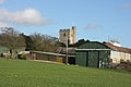
English: Ulcombe is a village near the town of Maidstone in Kent, England. The name has evolved from 'Owl-coomb', 'coomb' (pronounced 'coo-m') meaning 'a deep little wooded valley; a hollow in a hill side' (Chambers Dictionary) in Old English. It stands on the Greensand Way. The old village hall was dismantled and re-erected at the Museum of Kent Life, Sandling, having been made redundant by the construction of a new building.
Main Wikipedia article: Ulcombe.

village and civil parish in Kent, England, UK  | |||||
| Upload media | |||||
| Instance of | |||||
|---|---|---|---|---|---|
| Location | Maidstone, Kent, South East England, England | ||||
 | |||||
Subcategories
This category has the following 5 subcategories, out of 5 total.
C
- Chegworth (8 F)
F
- Fairbourne Heath (5 F)
K
- Kingsnorth Manor Farmhouse (2 F)
O
- Oasts in Ulcombe (30 F)
U
Media in category "Ulcombe"
The following 183 files are in this category, out of 183 total.
-
 'Harrow Inn', Ulcombe, Kent - geograph.org.uk - 3961456.jpg 3,259 × 2,149; 1.28 MB
-
 A wedding at Ulcombe - geograph.org.uk - 4080797.jpg 4,000 × 3,000; 4.1 MB
-
 All Saints Church, Ulcombe - geograph.org.uk - 3956484.jpg 2,170 × 3,340; 1.83 MB
-
 All Saints' Church - geograph.org.uk - 3359032.jpg 640 × 426; 71 KB
-
 All Saints' Church ^ Church Farm - geograph.org.uk - 3359049.jpg 640 × 426; 56 KB
-
 Barbed Wire Stile - geograph.org.uk - 1220557.jpg 480 × 640; 150 KB
-
 Bend, Windmill Hill - geograph.org.uk - 3357443.jpg 640 × 426; 68 KB
-
 Boy Court - geograph.org.uk - 1220601.jpg 640 × 480; 133 KB
-
 Boy Court Barn - geograph.org.uk - 1220605.jpg 640 × 480; 135 KB
-
 Boy Court Farmhouse - geograph.org.uk - 1913932.jpg 1,024 × 768; 342 KB
-
 Boy Court Lane - geograph.org.uk - 3364354.jpg 2,274 × 1,440; 3.29 MB
-
 Brick Kiln Lane, near Ulcombe - geograph.org.uk - 4903285.jpg 3,264 × 2,448; 2.78 MB
-
 Brick Kiln Lane, near Ulcombe - geograph.org.uk - 4903290.jpg 3,264 × 2,448; 2.55 MB
-
 Brick Kiln Lane, near Ulcombe - geograph.org.uk - 4903293.jpg 3,264 × 2,448; 3.39 MB
-
 Bridleway on Lenham Road - geograph.org.uk - 1189266.jpg 481 × 640; 116 KB
-
 By the Greensand Way - geograph.org.uk - 3359013.jpg 640 × 426; 91 KB
-
 Chegworth Lane, Chegworth - geograph.org.uk - 5032806.jpg 3,264 × 2,448; 2.46 MB
-
 Chegworth Road, Chegworth - geograph.org.uk - 5032830.jpg 3,264 × 2,448; 2.46 MB
-
 Chestnut Close, Ulcombe - geograph.org.uk - 4902232.jpg 3,264 × 2,448; 1.74 MB
-
 Chicory in a field - geograph.org.uk - 4081445.jpg 4,000 × 3,000; 4.13 MB
-
 Church Farm - geograph.org.uk - 3359044.jpg 640 × 426; 56 KB
-
 Church Farmhouse - geograph.org.uk - 3359034.jpg 640 × 426; 64 KB
-
 Church Farmhouse - geograph.org.uk - 3359036.jpg 640 × 426; 77 KB
-
 Cleared Woodland alongside Lenham Road - geograph.org.uk - 1189284.jpg 640 × 481; 111 KB
-
 Contrast in housing on The Street - Ulcombe - geograph.org.uk - 3968461.jpg 3,577 × 2,369; 2.27 MB
-
 Coppiced area, Kings Wood - geograph.org.uk - 4990453.jpg 640 × 480; 162 KB
-
 Cottage west of Church Farm - geograph.org.uk - 3359042.jpg 640 × 426; 48 KB
-
 Cottages by Little Peckham Farm - geograph.org.uk - 4770153.jpg 640 × 428; 133 KB
-
 Crest&Helm RalphIStLeger Died1470 UlcombeKent.jpg 240 × 416; 44 KB
-
 Crop sprayer - geograph.org.uk - 3357444.jpg 640 × 426; 105 KB
-
 Crump's Lane, near Ulcombe - geograph.org.uk - 4903252.jpg 3,264 × 2,448; 3.9 MB
-
 Crumps Lane - geograph.org.uk - 890301.jpg 640 × 480; 124 KB
-
 Ducks near Knowle Hill - geograph.org.uk - 4085933.jpg 4,000 × 3,000; 4.38 MB
-
 Eastwood Road, Ulcombe - geograph.org.uk - 4902236.jpg 3,264 × 2,448; 2.56 MB
-
 Elm Cottage - geograph.org.uk - 395162.jpg 640 × 434; 302 KB
-
 Entrance to Tilden Wood - geograph.org.uk - 4770164.jpg 640 × 428; 198 KB
-
 Exercise obstacle apparatus - geograph.org.uk - 2956990.jpg 640 × 480; 161 KB
-
 Farm building by the Greensand Way - geograph.org.uk - 3359019.jpg 640 × 426; 108 KB
-
 Farmland by the Greensand Way - geograph.org.uk - 3357377.jpg 640 × 426; 68 KB
-
 Farmland by the Greensand Way - geograph.org.uk - 3357472.jpg 640 × 426; 62 KB
-
 Field by Elmstone Hole Rd - geograph.org.uk - 3357372.jpg 640 × 426; 83 KB
-
 Field by the Greensand Way - geograph.org.uk - 3357371.jpg 640 × 327; 47 KB
-
 Fields to East of Ulcombe - geograph.org.uk - 2090095.jpg 640 × 427; 92 KB
-
 Footpath and Track off Tilden road - geograph.org.uk - 3364349.jpg 2,464 × 1,632; 1.03 MB
-
 Footpath to Ulcombe - geograph.org.uk - 4677140.jpg 4,608 × 3,456; 3.37 MB
-
 Grassland by the Greensand Way - geograph.org.uk - 3359046.jpg 640 × 426; 42 KB
-
 Greenhill Rd - geograph.org.uk - 3355634.jpg 640 × 426; 112 KB
-
 Greenhill Rd - geograph.org.uk - 3355636.jpg 640 × 426; 127 KB
-
 Greensand Way - geograph.org.uk - 3357373.jpg 640 × 426; 91 KB
-
 Greensand Way along field edge - geograph.org.uk - 3357470.jpg 640 × 426; 103 KB
-
 Greensand Way crosses Knowle Hill Lane - geograph.org.uk - 1189044.jpg 481 × 640; 124 KB
-

-
 Greensand Way heading east - geograph.org.uk - 3359021.jpg 640 × 426; 107 KB
-
 Greensand Way to Ulcombe - geograph.org.uk - 3359010.jpg 640 × 426; 77 KB
-
 Greensand Way, near Ulcombe - geograph.org.uk - 4902205.jpg 3,264 × 2,448; 2.63 MB
-
 Greensand Way, Windmill Hill - geograph.org.uk - 3357450.jpg 640 × 426; 67 KB
-
 Headcorn Road, near Ulcombe - geograph.org.uk - 4903221.jpg 3,264 × 2,448; 2.8 MB
-
 Headcorn Road, near Ulcombe - geograph.org.uk - 4903249.jpg 3,264 × 2,448; 3.14 MB
-
 Homesby Court - geograph.org.uk - 1202819.jpg 640 × 480; 92 KB
-
 Houses at junction on Headcorn Road - geograph.org.uk - 1042468.jpg 640 × 427; 72 KB
-
 In Tilden Wood - geograph.org.uk - 4770181.jpg 640 × 428; 194 KB
-
 Inn Sign -'Harrow Inn' - Ulcombe - geograph.org.uk - 3961481.jpg 2,691 × 4,051; 2.7 MB
-
 Jubilee Barn - geograph.org.uk - 1222774.jpg 640 × 480; 88 KB
-
 Jubilee Hall - geograph.org.uk - 1222772.jpg 640 × 480; 120 KB
-
 Kings Wood - geograph.org.uk - 1730855.jpg 640 × 480; 155 KB
-
 Kings Wood - geograph.org.uk - 1730860.jpg 640 × 480; 134 KB
-
 Knowle Hill Farm Cottage - geograph.org.uk - 1202829.jpg 640 × 480; 70 KB
-
 Knowle Hill House - geograph.org.uk - 2956821.jpg 640 × 480; 113 KB
-

-
 Lane off Windmill Hill, Ulcombe, Kent - geograph.org.uk - 1044655.jpg 640 × 480; 206 KB
-
 Lenham Road - geograph.org.uk - 1159293.jpg 640 × 427; 76 KB
-
 Lenham Road Kingswood - geograph.org.uk - 4638360.jpg 640 × 480; 122 KB
-
 Lenham Road, near Headcorn - geograph.org.uk - 5544069.jpg 3,264 × 2,448; 1.72 MB
-
 Little Boy Court - geograph.org.uk - 1220589.jpg 640 × 480; 94 KB
-
 Lone Tree Panorama - geograph.org.uk - 6062787.jpg 1,024 × 365; 93 KB
-
 Lower Knowle Hill Farm - geograph.org.uk - 83297.jpg 640 × 480; 135 KB
-
 Lower Knowle Hill House - geograph.org.uk - 1202825.jpg 640 × 480; 72 KB
-
 Mansion House Farmhouse (geograph 6571734).jpg 1,024 × 684; 325 KB
-

-
 Modern Building in Grafty Green - geograph.org.uk - 1600659.jpg 640 × 427; 59 KB
-
 Narrow Lane heading North West towards Chegworth - geograph.org.uk - 5078884.jpg 1,600 × 1,067; 855 KB
-
 Natural Spring in tree hollow - geograph.org.uk - 1220549.jpg 640 × 480; 132 KB
-

-
 New footbridge and stile - geograph.org.uk - 1220555.jpg 480 × 640; 108 KB
-
 Orchard off Water Lane - geograph.org.uk - 5078883.jpg 1,600 × 1,067; 804 KB
-
 Orchard on Windmill Hill - geograph.org.uk - 3357446.jpg 640 × 426; 100 KB
-
 Orchards near Ulcombe - geograph.org.uk - 3361781.jpg 640 × 426; 73 KB
-
 Paddock North of Chegworth - geograph.org.uk - 5078886.jpg 1,600 × 1,067; 616 KB
-
 Path Around Tilden Wood - geograph.org.uk - 6062749.jpg 678 × 1,024; 254 KB
-
 Path junction, Kings Wood - geograph.org.uk - 4990462.jpg 640 × 480; 236 KB
-
 Pheasant Farm - geograph.org.uk - 1222758.jpg 640 × 480; 108 KB
-
 Pollards by a Stream - geograph.org.uk - 6062821.jpg 678 × 1,024; 283 KB
-
 Pond By The Ruined Shelter - geograph.org.uk - 6062808.jpg 1,024 × 678; 212 KB
-
 Provender Lodge - geograph.org.uk - 1207322.jpg 640 × 480; 63 KB
-
 Raspberry growing near Ulcombe - geograph.org.uk - 4677138.jpg 4,608 × 3,456; 3.33 MB
-
 Rear edge of Tilden Wood - geograph.org.uk - 4770169.jpg 640 × 428; 184 KB
-
 Remains of an orchard - geograph.org.uk - 3355622.jpg 640 × 426; 78 KB
-
 Reservoir for sale^ - geograph.org.uk - 4904227.jpg 640 × 480; 115 KB
-
 Road Junction - geograph.org.uk - 3364358.jpg 2,464 × 1,632; 1.04 MB
-
 Roselands Farm - geograph.org.uk - 2956847.jpg 640 × 480; 95 KB
-
 Roselands Farmhouse (geograph 6587031).jpg 1,024 × 684; 243 KB
-
 Ruined Stone Shelter - geograph.org.uk - 6062799.jpg 678 × 1,024; 234 KB
-
 Skeleton of a Barn - geograph.org.uk - 1220596.jpg 640 × 480; 92 KB
-
 Sleeper Bridge - geograph.org.uk - 1220547.jpg 640 × 480; 139 KB
-
 Sleeper footbridge and stile - geograph.org.uk - 1220610.jpg 640 × 480; 115 KB
-
 Stickfast Lane, near Ulcombe - geograph.org.uk - 4903269.jpg 3,264 × 2,448; 2.62 MB
-
 Stickfast Lane, near Ulcombe - geograph.org.uk - 4903274.jpg 3,264 × 2,448; 2.98 MB
-
 Streetfield, Ulcombe - geograph.org.uk - 4902211.jpg 3,264 × 2,448; 1.64 MB
-
 The Gate to Tilden Wood - geograph.org.uk - 6062720.jpg 1,024 × 678; 277 KB
-
 The Greensand Way - geograph.org.uk - 3355625.jpg 640 × 426; 91 KB
-
 The Greensand Way - geograph.org.uk - 3355627.jpg 640 × 426; 76 KB
-
 The Greensand Way - geograph.org.uk - 3357375.jpg 640 × 426; 78 KB
-
 The Greensand Way - geograph.org.uk - 3359017.jpg 640 × 426; 146 KB
-
 The Greensand Way - geograph.org.uk - 3361782.jpg 640 × 426; 79 KB
-
 The Greensand Way - geograph.org.uk - 3361784.jpg 640 × 426; 85 KB
-
 The Greensand Way crosses a lane near Ulcombe - geograph.org.uk - 4081486.jpg 4,000 × 3,000; 4.39 MB
-
 The Greensand Way crosses a lane near Ulcombe - geograph.org.uk - 4081490.jpg 4,000 × 3,000; 4.51 MB
-

-
 The Greensand Way near Ulcombe - geograph.org.uk - 4081433.jpg 4,000 × 3,000; 4.49 MB
-
 The Greensand Way passing through coppiced woodland - geograph.org.uk - 4081464.jpg 4,000 × 3,000; 3.99 MB
-
 The Harrow Inn, Ulcombe - geograph.org.uk - 2956814.jpg 640 × 480; 130 KB
-
 The Harrow Inn, Ulcombe - geograph.org.uk - 4902216.jpg 3,264 × 2,448; 1.37 MB
-
 The Harrow Public House, Ulcombe - geograph.org.uk - 1207548.jpg 640 × 480; 54 KB
-
 The Harrow sign - geograph.org.uk - 2090069.jpg 480 × 640; 91 KB
-
 The Harrow, Ulcombe - geograph.org.uk - 2090063.jpg 640 × 480; 67 KB
-
 The Pepper Box Inn, Fairbourne Heath - geograph.org.uk - 2077517.jpg 3,139 × 2,354; 2.62 MB
-
 The Pepperbox sign - geograph.org.uk - 2089944.jpg 480 × 640; 122 KB
-
 The Pepperbox, Fairbourne Heath - geograph.org.uk - 2089940.jpg 640 × 427; 83 KB
-
 The Pipe Cot - geograph.org.uk - 2090183.jpg 640 × 480; 88 KB
-
 The Street, Ulcombe - geograph.org.uk - 4902208.jpg 3,264 × 2,448; 1.68 MB
-
 The Street, Ulcombe - geograph.org.uk - 4902217.jpg 3,264 × 2,448; 1.51 MB
-
 The Street, Ulcombe - geograph.org.uk - 4902220.jpg 3,264 × 2,448; 1.73 MB
-
 The Street, Ulcombe - geograph.org.uk - 4902225.jpg 3,264 × 2,448; 2.06 MB
-
 The wall of All Saints Church, Ulcombe - geograph.org.uk - 4085935.jpg 4,000 × 3,000; 4.36 MB
-
 The wall of All Saints, Ulcombe - geograph.org.uk - 4081427.jpg 4,000 × 3,000; 4.37 MB
-
 Tilden Road, near Ulcombe - geograph.org.uk - 4903260.jpg 3,264 × 2,448; 2.68 MB
-
 Tilden Wood - geograph.org.uk - 6062730.jpg 1,024 × 678; 274 KB
-
 Tilden Wood and Peckham Farm - geograph.org.uk - 6062740.jpg 678 × 1,024; 307 KB
-
 Trimmed hedge, Tilden Road - geograph.org.uk - 4770185.jpg 640 × 428; 114 KB
-
 Two trees - geograph.org.uk - 2956840.jpg 640 × 480; 133 KB
-

-
 Ulcombe church tower above the trees - geograph.org.uk - 3359007.jpg 640 × 405; 77 KB
-
 Ulcombe Hill - geograph.org.uk - 3359023.jpg 640 × 426; 84 KB
-
 Ulcombe Hill - geograph.org.uk - 3359024.jpg 640 × 426; 76 KB
-
 Ulcombe Hill, Ulcombe - geograph.org.uk - 4902206.jpg 3,264 × 2,448; 3.99 MB
-
 Ulcombe Hill, Ulcombe - geograph.org.uk - 4902207.jpg 3,264 × 2,448; 2.19 MB
-
 Ulcombe Hill, Ulcombe, Kent - geograph.org.uk - 1044653.jpg 640 × 427; 121 KB
-
 Ulcombe Primary School - geograph.org.uk - 1227711.jpg 640 × 427; 75 KB
-
 Ulcombe Village Sign - geograph.org.uk - 1207324.jpg 480 × 640; 88 KB
-
 Ulcombe Village Sign - geograph.org.uk - 4902239.jpg 3,264 × 2,448; 2.84 MB
-
 Upper Little Boy Court Farm - geograph.org.uk - 1913869.jpg 1,024 × 768; 251 KB
-
 Upperhill Farm - geograph.org.uk - 3357441.jpg 640 × 426; 121 KB
-
 Victorian Postbox, Ulcombe - geograph.org.uk - 3359026.jpg 640 × 426; 98 KB
-
 View from Knole Hill - geograph.org.uk - 2956833.jpg 640 × 480; 86 KB
-
 View from the Greensand Ridge - geograph.org.uk - 3357473.jpg 640 × 426; 83 KB
-
 View from the Greensand Way - geograph.org.uk - 3361783.jpg 640 × 426; 49 KB
-
 View from Windmill Hill - geograph.org.uk - 3357447.jpg 640 × 426; 78 KB
-
 View from Windmill Hill - geograph.org.uk - 3357469.jpg 640 × 426; 75 KB
-
 View to Ulcombe Village - geograph.org.uk - 3359012.jpg 640 × 426; 74 KB
-
 Walking the Greensand Way - geograph.org.uk - 4081438.jpg 4,000 × 3,000; 4.46 MB
-
 Waterlane Farm - geograph.org.uk - 1190588.jpg 640 × 481; 81 KB
-
 Waterlane Farm - geograph.org.uk - 5078881.jpg 1,600 × 1,067; 742 KB
-
 Weald View Farm - geograph.org.uk - 3357434.jpg 640 × 426; 67 KB
-
 Weald View Farmhouse - geograph.org.uk - 3357435.jpg 640 × 410; 56 KB
-
 Wents Service Station - geograph.org.uk - 77033.jpg 640 × 480; 95 KB
-
 Wesley Cottage - geograph.org.uk - 1207320.jpg 640 × 480; 73 KB
-
 Wild chicory - geograph.org.uk - 4081457.jpg 4,000 × 3,000; 4.36 MB
-
 Windmill Hill - geograph.org.uk - 3357436.jpg 640 × 426; 71 KB
-
 Windmill Hill - geograph.org.uk - 3357437.jpg 640 × 426; 104 KB
-
 Wooded pond - geograph.org.uk - 3359014.jpg 640 × 426; 123 KB
-
 Wooded valley east of Ulcombe - geograph.org.uk - 3359009.jpg 640 × 426; 86 KB
-
 Children's play area - geograph.org.uk - 76520.jpg 640 × 480; 159 KB
-
 Coppice in Kingswood - geograph.org.uk - 63762.jpg 510 × 640; 208 KB
-
 Eastwood Bungalow - geograph.org.uk - 395207.jpg 640 × 386; 273 KB
-
 Eastwood Farmhouse - geograph.org.uk - 712298.jpg 640 × 425; 68 KB
-
 Farm Building Near Ulcombe - geograph.org.uk - 47508.jpg 640 × 480; 108 KB
-
 Field beside Gravelly Bottom Road - geograph.org.uk - 76185.jpg 640 × 480; 168 KB
-
 Jubilee Corner - geograph.org.uk - 47505.jpg 640 × 480; 131 KB
-
 Junction in Kingswood - geograph.org.uk - 76519.jpg 640 × 477; 90 KB
-
 Kingswood road junction - geograph.org.uk - 75679.jpg 640 × 480; 151 KB
-
 Sewage Works - geograph.org.uk - 395181.jpg 640 × 427; 325 KB
-

-


.jpg)


.jpg)


