Category:Ulmizbergturm
| Object location | | View all coordinates using: OpenStreetMap |
|---|
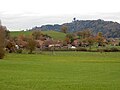
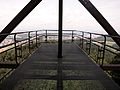
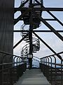
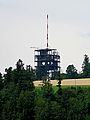
antenna tower with viewing platform in Schliern in the municipality of Köniz in the canton of Bern, Switzerland  | |||||
| Upload media | |||||
| Instance of | |||||
|---|---|---|---|---|---|
| Part of | |||||
| Location | Gasel, Köniz, Bern-Mittelland administrative district, Bernese Mittelland administrative region, Bern, Switzerland | ||||
| Street address |
| ||||
| Architect | |||||
| Commissioned by | |||||
| Heritage designation |
| ||||
| Inception |
| ||||
| Significant event |
| ||||
| Height |
| ||||
| Elevation above sea level |
| ||||
 | |||||
Media in category "Ulmizbergturm"
The following 17 files are in this category, out of 17 total.
-
 20230902 Ulmizberg -25.tif 5,184 × 3,888; 103.32 MB
-
 20230902 Ulmizberg-1.tif 3,888 × 5,184; 102.83 MB
-
 20230902 Ulmizberg-2.tif 5,184 × 3,158; 87.43 MB
-
 20230902 Ulmizberg-3.tif 5,184 × 3,888; 104.42 MB
-
 Mengestorf Ueberblick.jpg 4,608 × 3,456; 3.04 MB
-
 Ulmizbergturm 2020 Panorama.jpg 15,000 × 3,940; 15.17 MB
-
 Ulmizbergturm 2020.jpg 6,936 × 9,248; 18.09 MB
-
 Ulmizbergturm N.JPG 4,000 × 3,000; 3 MB
-
 Ulmizbergturm NO.JPG 4,000 × 3,000; 2.9 MB
-
 Ulmizbergturm NW.JPG 4,000 × 3,000; 2.97 MB
-
 Ulmizbergturm O.JPG 4,000 × 3,000; 2.83 MB
-
 Ulmizbergturm Panorama.jpg 11,700 × 2,402; 5.93 MB
-
 Ulmizbergturm Plattform.JPG 4,000 × 3,000; 3.39 MB
-
 Ulmizbergturm Treppe.JPG 3,000 × 4,000; 2.37 MB
-
 Ulmizbergturm W.JPG 4,000 × 3,000; 2.4 MB
-
 Ulmizbergturm.JPG 3,000 × 4,000; 2.57 MB
-
 Ulmizbergturm2.JPG 3,000 × 4,000; 2.1 MB


