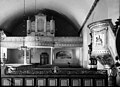
Category:Undersåkers kyrka
| Object location | | View all coordinates using: OpenStreetMap |
|---|
church building in Åre Municipality, Sweden  | |||||
| Upload media | |||||
| Instance of | |||||
|---|---|---|---|---|---|
| Location | Åre Municipality, Jämtland County, Sweden | ||||
| Diocese | |||||
| Has use |
| ||||
| Occupant |
| ||||
| Heritage designation |
| ||||
 | |||||
Svenska: Undersåkers kyrka tillhör Undersåkers församling, Krokom-Åre-Strömsunds kontrakt, Härnösands stift / Diocese of Härnösand.
|
This is a category about an ecclesiastical monument in Sweden, number 21300000003773 in the RAÄ buildings database.
|
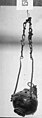
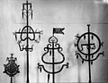
Media in category "Undersåkers kyrka"
The following 27 files are in this category, out of 27 total.
-
 Kyrkan i Undersåker.jpg 2,271 × 3,030; 1.86 MB
-
 Undersåkers kyrka - KMB - 16000200042847.jpg 800 × 569; 25 KB
-
 Undersåkers kyrka - KMB - 16000200042850.jpg 567 × 600; 27 KB
-
 Undersåkers kyrka - KMB - 16000200042852.jpg 558 × 600; 23 KB
-
 Undersåkers kyrka - KMB - 16000200042853.jpg 800 × 488; 23 KB
-
 Undersåkers kyrka - KMB - 16000200042859.jpg 800 × 579; 37 KB
-
 Undersåkers kyrka - KMB - 16000200042860.jpg 800 × 585; 30 KB
-
 Undersåkers kyrka - KMB - 16000200042862.jpg 800 × 576; 28 KB
-
 Undersåkers kyrka - KMB - 16000200042864.jpg 800 × 576; 23 KB
-
 Undersåkers kyrka - KMB - 16000200042871.jpg 800 × 582; 38 KB
-
 Undersåkers kyrka - KMB - 16000200042872.jpg 800 × 575; 30 KB
-
 Undersåkers kyrka - KMB - 16000200042873.jpg 436 × 600; 25 KB
-
 Undersåkers kyrka - KMB - 16000200042876.jpg 780 × 600; 38 KB
-
 Undersåkers kyrka - KMB - 16000200042878.jpg 800 × 555; 24 KB
-
 Undersåkers kyrka - KMB - 16000200042882.jpg 424 × 600; 14 KB
-
 Undersåkers kyrka - KMB - 16000200042899.jpg 426 × 600; 26 KB
-
 Undersåkers kyrka - KMB - 16000200042922.jpg 561 × 600; 26 KB
-
 Undersåkers kyrka - KMB - 16000200042923.jpg 427 × 600; 19 KB
-
 Undersåkers kyrka - KMB - 16000200042924.jpg 453 × 600; 18 KB
-
 Undersåkers kyrka - KMB - 16000200042935.jpg 213 × 600; 7 KB
-
 Undersåkers kyrka - KMB - 16000200042964.jpg 776 × 600; 18 KB
-
 Undersåkers kyrka - KMB - 16000200042965.jpg 689 × 600; 19 KB
-
 Undersåkers kyrka - KMB - 16000200042966.jpg 91 × 600; 5 KB
-
 Undersåkers kyrka - KMB - 16000200042967.jpg 794 × 600; 23 KB
-
 Undersåkers kyrka - KMB - 16000200042968.jpg 800 × 582; 25 KB
-
 Undersåkers kyrka - KMB - 16000200042969.jpg 778 × 600; 30 KB
-
 Undersåkers kyrka.jpg 2,189 × 2,930; 1.82 MB


