Category:United Kingdom photographs taken on 2007-10-25
Countries of Europe: Austria · Belgium · Bulgaria · Denmark · Finland · France‡ · Germany · Republic of Ireland · Italy · Latvia · Lithuania · Netherlands‡ · Poland · Portugal‡ · Russia‡ · Serbia · Spain‡ · Sweden · Switzerland · United Kingdom
Specific status: Isle of Man
‡: partly located in Europe
Specific status: Isle of Man
‡: partly located in Europe
| ← | 25 October 2007 | → | ||
| ← | October 2007 | → | ||

United Kingdom photographs taken on 25 October 2007.
Image files should be categorized here automatically using {{taken on}} template. Direct categorisation is also possible, if automatic is impossible.
Subcategories
This category has the following 2 subcategories, out of 2 total.
Media in category "United Kingdom photographs taken on 2007-10-25"
The following 200 files are in this category, out of 336 total.
(previous page) (next page)-
 A drain on the moss - geograph.org.uk - 595286.jpg 640 × 480; 136 KB
-
 A Welsh Farm - geograph.org.uk - 595342.jpg 640 × 480; 88 KB
-

-
 ABS Business Park - Viaduct Street - geograph.org.uk - 594541.jpg 640 × 369; 19 KB
-
 Aerogenerator on Burra Dale - geograph.org.uk - 595009.jpg 426 × 640; 147 KB
-
 Arnold's Hill - geograph.org.uk - 597484.jpg 640 × 480; 68 KB
-
 Atlantic wave, Portrush (1 of 3) - geograph.org.uk - 594597.jpg 640 × 427; 90 KB
-
 Atlantic wave, Portrush (2 of 3) - geograph.org.uk - 594612.jpg 640 × 427; 82 KB
-
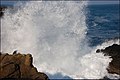 Atlantic wave, Portrush (3 of 3) - geograph.org.uk - 594624.jpg 640 × 427; 78 KB
-
 Autumn leaves, Coleraine - geograph.org.uk - 594549.jpg 640 × 427; 146 KB
-
 Avebury Henge - geograph.org.uk - 595474.jpg 640 × 427; 274 KB
-
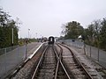 Avon Riverside level crossing - geograph.org.uk - 610580.jpg 640 × 480; 61 KB
-
 Avon Valley Railway level crossing - geograph.org.uk - 610582.jpg 640 × 480; 66 KB
-
-

-

-
 Bertie Peacock statue (cropped).jpg 304 × 457; 51 KB
-

-
 Bertie Peacock statue, Coleraine - geograph.org.uk - 594512.jpg 640 × 474; 92 KB
-
 Between the Stones - geograph.org.uk - 595383.jpg 640 × 404; 251 KB
-
 Beverley Road - geograph.org.uk - 594986.jpg 640 × 480; 90 KB
-
 Bex93 wiki.jpg 900 × 600; 342 KB
-
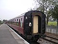
 Bitton railway station - geograph.org.uk - 610585.jpg 640 × 480; 60 KB
-
 Blands - geograph.org.uk - 595529.jpg 640 × 480; 94 KB
-
 Blue Steel - geograph.org.uk - 595099.jpg 640 × 480; 81 KB
-
 Boat on the River Avon - geograph.org.uk - 610577.jpg 640 × 480; 62 KB
-
 Boats at night (1) - geograph.org.uk - 594769.jpg 640 × 505; 53 KB
-
 Border post - geograph.org.uk - 595277.jpg 640 × 480; 90 KB
-
 Brazenose Gate - geograph.org.uk - 600898.jpg 640 × 427; 96 KB
-
 Brazenose Gate knocker - geograph.org.uk - 600904.jpg 484 × 640; 79 KB
-
 Brazenose Gate plaque - geograph.org.uk - 600922.jpg 640 × 427; 101 KB
-
 Brazenose House - geograph.org.uk - 601602.jpg 640 × 427; 75 KB
-
 Brazenose House from Stamford School - geograph.org.uk - 601606.jpg 640 × 427; 76 KB
-
 Bridge 14, Union Canal - geograph.org.uk - 918291.jpg 480 × 640; 92 KB
-
 Bridge LBE1-30 - over Viaduct Street - geograph.org.uk - 594537.jpg 640 × 422; 34 KB
-
 Bridgnorth High Street - geograph.org.uk - 798150.jpg 640 × 480; 80 KB
-
 Bringing home the bacon - geograph.org.uk - 595946.jpg 640 × 480; 95 KB
-
 Byard House - geograph.org.uk - 601607.jpg 427 × 640; 56 KB
-
 Carlton Methodist Church - geograph.org.uk - 594608.jpg 640 × 426; 83 KB
-
 Carlton, The Odddfellows Arms - geograph.org.uk - 595600.jpg 640 × 480; 74 KB
-
 Cattle on rough grazing - geograph.org.uk - 594760.jpg 640 × 480; 119 KB
-
 Cherry Island - geograph.org.uk - 648235.jpg 416 × 640; 135 KB
-
 Cinder Path to Seascale - geograph.org.uk - 993253.jpg 640 × 480; 65 KB
-
 City Hotel, Queen's Quay - geograph.org.uk - 595080.jpg 640 × 480; 63 KB
-

-
 Cliff path, Portrush - geograph.org.uk - 594583.jpg 640 × 427; 92 KB
-
 Club Moss - geograph.org.uk - 594704.jpg 640 × 427; 352 KB
-
 Coastal Path near Pilling Lane - geograph.org.uk - 618968.jpg 640 × 480; 60 KB
-
 Converted windmill - geograph.org.uk - 595945.jpg 640 × 480; 89 KB
-
 Course of redundant railway - geograph.org.uk - 594971.jpg 640 × 480; 122 KB
-
 Course of redundant railway - geograph.org.uk - 595296.jpg 640 × 480; 93 KB
-
 Craigavon Bridge - geograph.org.uk - 595177.jpg 640 × 480; 54 KB
-
 Craigavon Bridge - geograph.org.uk - 595191.jpg 480 × 640; 68 KB
-
 Cranester Bog - geograph.org.uk - 594746.jpg 640 × 480; 106 KB
-
 Culvert Under the A76 - geograph.org.uk - 598840.jpg 640 × 427; 75 KB
-
 Danger of death - geograph.org.uk - 594286.jpg 600 × 450; 123 KB
-
 Drystone walls below Swineber Scar - geograph.org.uk - 604032.jpg 640 × 480; 57 KB
-
 Duck pond on Whaup Moss - geograph.org.uk - 594752.jpg 640 × 480; 120 KB
-
 Early Morning Toucan - geograph.org.uk - 595189.jpg 640 × 480; 44 KB
-
 Eastern End of Morton Loch - geograph.org.uk - 600742.jpg 640 × 427; 72 KB
-
 Entrance to Crookhill Park golf course - geograph.org.uk - 595966.jpg 640 × 480; 145 KB
-
 Entrance to the Charnwood Hotel - geograph.org.uk - 595956.jpg 640 × 484; 84 KB
-
 Falls on the Oykel - geograph.org.uk - 595264.jpg 640 × 480; 142 KB
-
 Farm buildings - geograph.org.uk - 595591.jpg 640 × 480; 95 KB
-
 Farmers' Market on Car Park - geograph.org.uk - 594522.jpg 640 × 418; 32 KB
-
 Fell Views From Harecroft - geograph.org.uk - 993274.jpg 640 × 480; 80 KB
-

-

-
 Fine black Highlands, near Torroy - geograph.org.uk - 605963.jpg 640 × 480; 112 KB
-
 Forest near Archiestown - geograph.org.uk - 594836.jpg 640 × 427; 234 KB
-
 Foundry Lane - Stanningley - geograph.org.uk - 594530.jpg 481 × 640; 34 KB
-
 Four-Way Traffic - geograph.org.uk - 595171.jpg 640 × 480; 59 KB
-
 Foyle Reflections - geograph.org.uk - 595167.jpg 455 × 640; 76 KB
-
 Full moon over Toft pier - geograph.org.uk - 595064.jpg 640 × 426; 24 KB
-
 Fungi (species unknown) - geograph.org.uk - 594639.jpg 640 × 416; 213 KB
-
 Fungi (species unknown) - geograph.org.uk - 594698.jpg 640 × 286; 189 KB
-
 Glacial scouring, near Oykel Bridge - geograph.org.uk - 595268.jpg 640 × 480; 158 KB
-
 Gogar Moor Bridge 14 from Ratho - geograph.org.uk - 918307.jpg 480 × 640; 133 KB
-
 Grazing land on the edge of the moss - geograph.org.uk - 595594.jpg 640 × 480; 83 KB
-
 Gresham Village Sign 25th October 2007.JPG 1,920 × 2,560; 1.14 MB
-
 Griesta, Tingwall - geograph.org.uk - 594945.jpg 640 × 426; 146 KB
-
 Gulberwick - geograph.org.uk - 594835.jpg 640 × 426; 136 KB
-
 Gwynedd crafts - geograph.org.uk - 598078.jpg 640 × 480; 100 KB
-
 Hand cut peats - geograph.org.uk - 595298.jpg 640 × 480; 136 KB
-
 Hempstead Watermill - geograph.org.uk - 1223950.jpg 480 × 640; 121 KB
-
 Hempstead Watermill - geograph.org.uk - 1223952.jpg 480 × 640; 129 KB
-
 High Raise Trig Pillar - geograph.org.uk - 707312.jpg 640 × 479; 75 KB
-
 Historical peat cuttings - geograph.org.uk - 595281.jpg 640 × 480; 64 KB
-
 Houses on Southfield - geograph.org.uk - 594501.jpg 640 × 426; 131 KB
-
 Humber Street - Not Suitable for Vehicles - geograph.org.uk - 594975.jpg 640 × 480; 111 KB
-

-
 Lane to Morton Castle - geograph.org.uk - 598835.jpg 640 × 427; 109 KB
-
-

-
 Loch Awe Village Hall - geograph.org.uk - 1098197.jpg 640 × 480; 68 KB
-
 Loch Urigill - geograph.org.uk - 594927.jpg 640 × 480; 89 KB
-
 Loch Urigill - geograph.org.uk - 595714.jpg 640 × 480; 98 KB
-
 Long Crag - geograph.org.uk - 594785.jpg 640 × 480; 156 KB
-

-
 Looking down to Loch Urigill - geograph.org.uk - 594889.jpg 640 × 480; 92 KB
-

-
 Marshfield High street and War Memorial - geograph.org.uk - 595310.jpg 640 × 427; 250 KB
-

-
 Mile House barns - geograph.org.uk - 604039.jpg 640 × 480; 61 KB
-
 Moel Hebog - geograph.org.uk - 598066.jpg 640 × 480; 71 KB
-
 Moss Cottages (1) - geograph.org.uk - 595575.jpg 640 × 480; 83 KB
-
 Moss Cottages (2) - geograph.org.uk - 595589.jpg 640 × 480; 67 KB
-
 National Trust Car Park, Avebury - geograph.org.uk - 595483.jpg 640 × 424; 256 KB
-
 Naval mine and stone seat - geograph.org.uk - 599070.jpg 640 × 480; 92 KB
-
 Near Parallels - geograph.org.uk - 595394.jpg 640 × 413; 214 KB
-
 Netherley House - geograph.org.uk - 1512996.jpg 480 × 640; 126 KB
-
 Newington, A76 - geograph.org.uk - 598844.jpg 640 × 427; 79 KB
-
 NISUS CS Church - Stanningley - geograph.org.uk - 594534.jpg 602 × 640; 52 KB
-
 October Morn - geograph.org.uk - 595190.jpg 640 × 480; 30 KB
-
 Old bridge at Oykel Bridge - geograph.org.uk - 608000.jpg 640 × 480; 158 KB
-
 Old buildings at An Leth-pheighinn - geograph.org.uk - 594671.jpg 640 × 425; 178 KB
-
 Old church near Invercassley - geograph.org.uk - 608054.jpg 640 × 480; 136 KB
-
 On the slopes of Comb Rigg - geograph.org.uk - 594773.jpg 640 × 480; 115 KB
-
 Paul Mccartney Roundhouse.jpg 1,747 × 1,328; 371 KB
-
 Penniless Cove Hill - geograph.org.uk - 599065.jpg 640 × 480; 57 KB
-
 Pill box on Scald Law - geograph.org.uk - 594735.jpg 640 × 480; 119 KB
-
 Plantation off the Catcherside Road - geograph.org.uk - 594791.jpg 640 × 480; 106 KB
-
 Point of Departure - geograph.org.uk - 595139.jpg 480 × 640; 109 KB
-

-
 Red Deer in Richmond Park - geograph.org.uk - 1166251.jpg 640 × 480; 68 KB
-
 Remains of Whorlton Old Church - geograph.org.uk - 594449.jpg 496 × 640; 137 KB
-
 Returning to its former glory - geograph.org.uk - 595274.jpg 640 × 480; 45 KB
-
 River Glaven at Selbrigg 25th October 2007.JPG 2,560 × 1,920; 1.14 MB
-
 River Glaven near its source at Lower Bodham 25th October 2007.JPG 1,920 × 2,560; 1.18 MB
-
 Road junction at Faceby - geograph.org.uk - 594560.jpg 640 × 480; 96 KB
-

-
 Salt marshes on the Dovey Estuary - geograph.org.uk - 594954.jpg 640 × 480; 172 KB
-

-
 Scalloway marina - geograph.org.uk - 594886.jpg 640 × 426; 106 KB
-
 School Mill Dam - geograph.org.uk - 598893.jpg 640 × 427; 90 KB
-
 Scugdale Beck at Swainby.jpg 480 × 640; 112 KB
-
 Selbrigg Pond 25th October 2007 (1).JPG 2,560 × 1,920; 1.25 MB
-
 Sheep - geograph.org.uk - 595898.jpg 640 × 426; 43 KB
-
 Shropshire Union Canal Bridge No. 44 - geograph.org.uk - 595055.jpg 640 × 480; 56 KB
-
 Snailsden Edge Shooters Track - geograph.org.uk - 595484.jpg 640 × 480; 98 KB
-
 Society Street, Coleraine (part) - geograph.org.uk - 594532.jpg 640 × 409; 73 KB
-
 South Parade - geograph.org.uk - 993268.jpg 640 × 480; 50 KB
-
 Southfield - geograph.org.uk - 594507.jpg 427 × 640; 190 KB
-

-
 St.Paul's conduit - geograph.org.uk - 614934.jpg 427 × 640; 88 KB
-
 St.Paul's Street - geograph.org.uk - 601598.jpg 640 × 427; 63 KB
-
 St.Paul's Street - geograph.org.uk - 614926.jpg 640 × 427; 76 KB
-
 St.Paul's Street - geograph.org.uk - 614932.jpg 427 × 640; 63 KB
-
 St.Paul's Street - geograph.org.uk - 614936.jpg 640 × 427; 64 KB
-
 Stamford School - geograph.org.uk - 600959.jpg 640 × 427; 54 KB
-
 Stone Circle, Avebury - geograph.org.uk - 595480.jpg 640 × 427; 244 KB
-
 Storage shed near Huthwaite Green - geograph.org.uk - 594722.jpg 640 × 480; 137 KB
-
 Streaky buses, Ferensway, Hull - panoramio.jpg 1,200 × 756; 880 KB
-
 Sunset at Seascale - geograph.org.uk - 993258.jpg 640 × 480; 33 KB
-
 Tanronnen Inn - geograph.org.uk - 598048.jpg 640 × 480; 89 KB
-
 Tanronnen Inn Beddgelert - geograph.org.uk - 598054.jpg 640 × 480; 87 KB
-
 Telephone Exchange - Vernon Place - geograph.org.uk - 594525.jpg 640 × 432; 37 KB
-
 The "Explorer" at Coleraine - geograph.org.uk - 594565.jpg 636 × 423; 60 KB
-
 The Barn Gallery, Avebury - geograph.org.uk - 595497.jpg 640 × 427; 334 KB
-
 The Bernwood Way - geograph.org.uk - 706760.jpg 640 × 425; 44 KB
-
 The Fells - geograph.org.uk - 993264.jpg 640 × 480; 55 KB
-
 The Fenn's Moss old works - geograph.org.uk - 595292.jpg 640 × 480; 121 KB
-
 The Great Hall, Morton Castle - geograph.org.uk - 604220.jpg 640 × 427; 75 KB
-
 The old lifeboat station, Barmouth - geograph.org.uk - 612482.jpg 480 × 640; 99 KB
-
 The point on Loch Urigill - geograph.org.uk - 594909.jpg 640 × 480; 115 KB
-
 The Town Bridge, Coleraine - geograph.org.uk - 594558.jpg 640 × 383; 66 KB
-
 They never - geograph.org.uk - 595901.jpg 640 × 426; 54 KB
-
 Toll House to Barmouth Bridge - geograph.org.uk - 607577.jpg 640 × 480; 78 KB
-
 Towering Abbey - geograph.org.uk - 597925.jpg 640 × 395; 51 KB
-
 Track beside the Shropshire Union canal - geograph.org.uk - 595303.jpg 640 × 480; 130 KB
-
 Tree Stump - geograph.org.uk - 594614.jpg 418 × 640; 323 KB
-
 Triangulation pillar on the summit of Kerloch - geograph.org.uk - 597076.jpg 2,272 × 1,704; 4.21 MB
-
 Trig point on the summit of Twthill - geograph.org.uk - 594077.jpg 640 × 480; 67 KB
-
 Ty Mawr - geograph.org.uk - 598006.jpg 640 × 480; 118 KB
-
 Ty Mawr - geograph.org.uk - 598019.jpg 640 × 480; 110 KB
-
 Upper Snailsden Moss - geograph.org.uk - 594795.jpg 640 × 480; 91 KB
-
 Uppersound, Lerwick - geograph.org.uk - 594796.jpg 640 × 426; 110 KB
-
 Veensgarth, Tingwall - geograph.org.uk - 594994.jpg 640 × 426; 130 KB
-
 Ventilated sheds at Whorl Hill Farm - geograph.org.uk - 594546.jpg 640 × 480; 66 KB
-
 Viaduct Street - geograph.org.uk - 594539.jpg 640 × 419; 22 KB
-

-
 View of Longfield - geograph.org.uk - 595186.jpg 640 × 480; 33 KB
-
 Vita Veritas Victoria - geograph.org.uk - 595108.jpg 480 × 640; 63 KB
-
 Wading birds - geograph.org.uk - 595849.jpg 640 × 269; 23 KB
-
 Wading birds - geograph.org.uk - 595859.jpg 640 × 426; 42 KB
-
 Wakefield, Thornes Park, Autumn Trees - panoramio.jpg 2,592 × 1,952; 2.02 MB
-
 Walking The Dogs - geograph.org.uk - 993256.jpg 640 × 480; 63 KB
-
 Wall Near Greenhead - geograph.org.uk - 598833.jpg 640 × 427; 75 KB
-
 Watchman Knowe - geograph.org.uk - 598827.jpg 640 × 427; 104 KB
-
 Waterfall on the Hamara River - geograph.org.uk - 594678.jpg 640 × 425; 177 KB
-
 Waterside from Craigavon Bridge - geograph.org.uk - 595182.jpg 640 × 480; 58 KB
-
 Wayside water gardens Oldcotes - geograph.org.uk - 595961.jpg 640 × 350; 87 KB
-
 Well of Health, near Shandwick - geograph.org.uk - 595528.jpg 640 × 480; 119 KB
-
 Wern Cemetery, Minera - geograph.org.uk - 1010719.jpg 640 × 480; 366 KB
-
 West Beckham Village Sign.JPG 1,920 × 2,560; 1.18 MB
-
 West end of Morton Loch - geograph.org.uk - 598830.jpg 640 × 427; 84 KB
-
 What an hedge - geograph.org.uk - 595953.jpg 640 × 453; 122 KB
-
 Wheater's Fold - Stanningley - geograph.org.uk - 594527.jpg 640 × 479; 45 KB
-
 Wildlife Stump - geograph.org.uk - 594842.jpg 640 × 427; 273 KB
-
 Winscar Reservoir and Eastside Beach - geograph.org.uk - 594702.jpg 640 × 480; 100 KB


_-_geograph.org.uk_-_594597.jpg)
_-_geograph.org.uk_-_594612.jpg)
_-_geograph.org.uk_-_594624.jpg)


.jpg)
.jpg)


_-_geograph.org.uk_-_594769.jpg)


_-_geograph.org.uk_-_594639.jpg)
_-_geograph.org.uk_-_594698.jpg)


.jpg)


_-_geograph.org.uk_-_595575.jpg)
_-_geograph.org.uk_-_595589.jpg)


.JPG)


_-_geograph.org.uk_-_594532.jpg)


