Category:Unteres Türmlihaus, Furt
| Object location | | View all coordinates using: OpenStreetMap |
|---|
 | |||||
| Upload media | |||||
| Instance of | |||||
|---|---|---|---|---|---|
| Location |
| ||||
| Street address |
| ||||
| Heritage designation | |||||
 | |||||
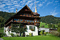
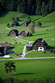
Deutsch: Das untere Türmlihaus ist ein Wohnhaus (heute Bauernhaus) im Weiler Furt (früher auch; Furth) auf dem Gebiet der politischen Gemeinde Neckertal im Kanton St. Gallen in der Schweiz.
Media in category "Unteres Türmlihaus, Furt"
The following 11 files are in this category, out of 11 total.
-
 Neckertal Furt Türmlihäuser.JPG 4,246 × 2,820; 4.85 MB
-
 Neckertal Unteres Türmlihaus s n.JPG 3,023 × 3,173; 2.71 MB
-
 Neckertal Unteres Türmlihaus s w.JPG 2,941 × 3,327; 3.17 MB
-
 Neckertal Unteres Türmlihaus so.JPG 4,071 × 2,765; 3.25 MB
-
 Neckertal Unteres Türmlihaus sw.JPG 2,653 × 3,377; 2.76 MB
-
 Toggenburg Unteres and Oberes Türmlihaus information plate.jpg 2,646 × 3,977; 5.39 MB
-
 Toggenburg Unteres Türmlihaus close-up.jpg 4,256 × 2,832; 9.33 MB
-
 Toggenburg Unteres Türmlihaus general overview.jpg 2,832 × 4,256; 9.53 MB
-
 Toggenburg Unteres Türmlihaus overview.jpg 4,256 × 2,832; 9.91 MB
-
 Toggenburg Unteres Türmlihaus with cow.jpg 2,635 × 4,045; 6.42 MB
-
 Toggenburg Unteres und Oberes Türmlihaus.jpg 2,683 × 4,115; 9.91 MB


