Category:Utting Avenue bridge on Canada Dock Branch
| Object location | | View all coordinates using: OpenStreetMap |
|---|
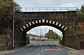
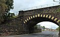
This is bridge SCT1/20 and carries the Canada Dock Branch over Utting Avenue at the boundary between Anfield and Clubmoor; it is 2.83 miles from Edge Hill junction.
Media in category "Utting Avenue bridge on Canada Dock Branch"
The following 5 files are in this category, out of 5 total.
-
 Benchmark on Utting Avenue Bridge.jpg 3,042 × 4,806; 8.67 MB
-
 Utting Avenue Bridge 1.jpg 5,043 × 3,336; 10.51 MB
-
 Utting Avenue Bridge 2.jpg 5,064 × 3,123; 8.65 MB
-
 Utting Avenue Bridge 3.jpg 4,785 × 3,198; 8.74 MB
-
 Utting Avenue bridge 4.jpg 4,986 × 3,336; 11.06 MB


