Category:Valentinkirche Dubrau
| Object location | | View all coordinates using: OpenStreetMap |
|---|
church building in Wiesengrund, Brandenburg state, Germany  | |||||
| Upload media | |||||
| Instance of | |||||
|---|---|---|---|---|---|
| Location | Dubrau/Dubrawa, Wiesengrund, Spree-Neiße District, Brandenburg, Germany | ||||
| Heritage designation | |||||
 | |||||
This is the category of the Brandenburger Baudenkmal (cultural heritage monument) with the ID 09125465 (Wikidata)
|
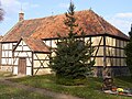
English: Pictures of the church St. Valentin in Dubrau, Wiesengrund municipality, Spree-Neiße district, Brandenburg state, Germany.
Deutsch: Ansichten der Kirche St. Valentin in Dubrau, Gemeinde Wiesengrund, Landkreis Spree-Neiße, Land Brandenburg, Deutschland.
Français : Photos de l'église St. Valentin à Dubrau, commune de Wiesengrund, arrondissement de Spree-Neiße, état fédéral de Brandebourg, Allemagne
Español: Vistas de la iglesia St. Valentin en Dubrau, municipio de Wiesengrund, distrito de Spree-Neiße, estado federado de Brandeburgo, Alemania
Address: Dubrauer Dorfstraße, 03149 Wiesengrund
Media in category "Valentinkirche Dubrau"
The following 3 files are in this category, out of 3 total.
-
 Dubrau - Kirche 0001.jpg 1,200 × 803; 377 KB
-
 Dubrau, Fachwerkkirche, denkmalgeschützt.jpg 800 × 600; 395 KB
-
 Fachwerkkirche Dubrau.jpg 800 × 600; 467 KB

