Category:Van Randwijk-monument
| Object location | | View all coordinates using: OpenStreetMap |
|---|
 | |||||
| Upload media | |||||
| Instance of |
| ||||
|---|---|---|---|---|---|
| Named after | |||||
| Commemorates | |||||
| Genre | |||||
| Location | Amsterdam, North Holland, Netherlands | ||||
| Street address |
| ||||
| Located on street | |||||
| Inception |
| ||||
| Date of official opening |
| ||||
 | |||||
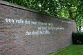
Nederlands: Het Van Randwijk-monument in Amsterdam, bij het Weteringcircuit, met tekst van H.M. van Randwijk.
|
This is a category about a war memorial in the Netherlands, number: 1513
|
een volk dat voor tirannen zwicht
zal meer dan lijf en goed verliezen
dan dooft het licht ...
Media in category "Van Randwijk-monument"
The following 9 files are in this category, out of 9 total.
-
 Een volk dat voor tirannen zwicht Van Randwijk Amsterdam 2018 2.jpg 4,928 × 3,264; 9.94 MB
-
 Een volk dat voor tirannen zwicht Van Randwijk Amsterdam 2018.jpg 4,928 × 3,264; 9.28 MB
-
 Een.volk.dat.voor.tirannen.zwicht.jpg 3,072 × 2,048; 2.84 MB
-

-

-
 Randwijkplantsoen (1).jpg 5,312 × 2,988; 7.04 MB
-
 Randwijkplantsoen (2).jpg 5,312 × 2,988; 8.77 MB
-
 Randwijkplantsoen (3).jpg 5,312 × 2,988; 3.44 MB
-
 Weteringplantsoen monument.JPG 3,888 × 2,592; 3.52 MB


.jpg)
.jpg)
.jpg)
