Category:Verbandsgemeinde Ruwer
Verbandsgemeinde in Rhineland-Palatinate   | |||||
| Upload media | |||||
| Instance of |
| ||||
|---|---|---|---|---|---|
| Location |
| ||||
| Population |
| ||||
| Area |
| ||||
| official website | |||||
 | |||||
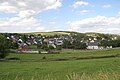
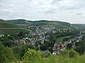
English: The Verbandsgemeinde Ruwer is a convention community southeast of Trier in Rhineland-Palatinate, Germany.
Nederlands: De Verbandsgemeinde Ruwer ligt in het district Trier-Saarburg in de Duitse deelstaat Rijnland-Palts.
Subcategories
This category has the following 20 subcategories, out of 20 total.
B
F
H
L
M
P
R
S
T
W
Pages in category "Verbandsgemeinde Ruwer"
This category contains only the following page.
Media in category "Verbandsgemeinde Ruwer"
The following 53 files are in this category, out of 53 total.
-
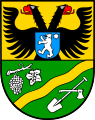 DEU Verbandsgemeinde Ruwer COA.svg 444 × 562; 209 KB
-
 Wappen-vg-ruwer.png 300 × 379; 40 KB
-
 Gebaeude in Trier-Ruwer Rheinstrasse.jpg 1,098 × 962; 122 KB
-
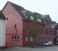
 Rathaus waldrach februar 2020.jpg 5,184 × 3,888; 3.3 MB
-
 Rathaus-waldrach-eingang.jpg 997 × 748; 150 KB
-
 Hissflagge-vg-ruwer.png 216 × 432; 3 KB
-
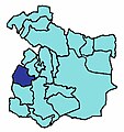
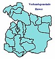 Karte-vg-ruwer.jpg 431 × 459; 36 KB
-
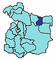
 Karte-bonerath.jpg 431 × 459; 33 KB
-
 Karte-farschweiler.jpg 431 × 459; 33 KB
-
 Karte-gusterath.jpg 431 × 459; 33 KB
-
 Karte-gutweiler.jpg 431 × 459; 33 KB
-
 Karte-herl.jpg 431 × 459; 33 KB
-
 Karte-hinzenburg.jpg 431 × 459; 33 KB
-
 Karte-holzerath.jpg 431 × 459; 33 KB
-
 Karte-kasel.jpg 431 × 459; 33 KB
-
 Karte-korlingen.jpg 431 × 459; 33 KB
-
 Karte-lorscheid.jpg 431 × 459; 33 KB
-
 Karte-mertesdorf.jpg 431 × 459; 33 KB
-
 Karte-morscheid.jpg 431 × 459; 33 KB
-
 Karte-ollmuth.jpg 431 × 459; 33 KB
-
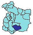
 Karte-osburg.jpg 431 × 459; 33 KB
-
 Karte-pluwig.jpg 431 × 459; 33 KB
-
 Karte-riveris.jpg 431 × 459; 33 KB
-
 Karte-schoendorf.jpg 431 × 459; 33 KB
-
 Karte-sommerau.jpg 431 × 459; 33 KB
-
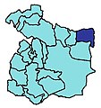
 Karte-thomm.jpg 431 × 459; 33 KB
-
 Karte-waldrach.jpg 431 × 459; 33 KB
-
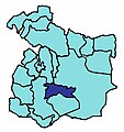
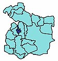
 Kreiskarte-trs-ruwer.png 250 × 214; 18 KB
-
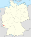 Lage der Verbandsgemeinde Ruwer in Deutschland.png 506 × 599; 82 KB
-
 Ruwer-hochwald-radweg-osm.jpg 917 × 774; 114 KB
-
 Verbandsgemeinde Ruwer in TR.svg 667 × 590; 412 KB
-
 Bonerath 2010.jpg 3,761 × 1,953; 657 KB
-
 Farschweiler01.jpg 3,008 × 2,000; 2.47 MB
-
 Geizenburg 2010.jpg 3,051 × 1,742; 518 KB
-
 Gusterath (Trier-Saarburg).jpg 2,631 × 1,350; 653 KB
-
 Gutweiler 2010.jpg 3,376 × 926; 395 KB
-
 Herl01.jpg 3,008 × 2,000; 2.46 MB
-
 Hinzenburg Winter.jpg 2,018 × 773; 163 KB
-
 Holzerath 2010.jpg 3,360 × 1,519; 403 KB
-
 Kasel 2010.jpg 4,000 × 3,000; 1.22 MB
-
 KorlingenGutweiler.jpg 3,264 × 2,448; 1.18 MB
-
 Lonzenburg 2010.jpg 1,927 × 1,226; 296 KB
-
 Lorscheid01.jpg 2,974 × 1,145; 1.26 MB
-
 Mertesdorf 2010.jpg 3,146 × 1,831; 578 KB
-
 Morscheid 2010.jpg 2,103 × 1,369; 324 KB
-
 Ollmuth 2010.jpg 3,661 × 2,098; 619 KB
-
 Osburg.jpg 3,995 × 1,712; 619 KB
-
 Pluwig 2010.jpg 2,404 × 1,221; 251 KB
-
 Riveris 2010.jpg 4,000 × 3,000; 1.32 MB
-
 Schoendorf-ruwer-18b.jpg 1,120 × 498; 142 KB
-
 Sommerau (Ruwer) mit Burgruine.jpg 4,896 × 2,752; 7.44 MB
-
 Thomm03.jpg 3,007 × 1,212; 1.47 MB
-
 Waldrach.jpg 3,782 × 2,256; 1.07 MB


.jpg)


_mit_Burgruine.jpg)
