Category:Voorstraat 362, Dordrecht
| Object location | | View all coordinates using: OpenStreetMap |
|---|
 | |||||
| Upload media | |||||
| Instance of |
| ||||
|---|---|---|---|---|---|
| Location | Dordrecht, South Holland, Netherlands | ||||
| Street address |
| ||||
| Heritage designation |
| ||||
 | |||||
|
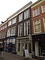
This is a category about rijksmonument number 13909
|
| Address |
|
Media in category "Voorstraat 362, Dordrecht"
The following 4 files are in this category, out of 4 total.
-
 Overzicht voorgevels - Dordrecht - 20062961 - RCE.jpg 817 × 1,200; 214 KB
-
 Overzicht voorgevels - Dordrecht - 20062962 - RCE.jpg 823 × 1,200; 227 KB
-
 RM13909 Dordrecht - Voorstraat 362.jpg 2,448 × 3,264; 1.74 MB
-
 Voorgevels - Dordrecht - 20062960 - RCE.jpg 804 × 1,200; 152 KB


