Category:Waldaschaff
municipality of Germany    | |||||
| Upload media | |||||
| Instance of |
| ||||
|---|---|---|---|---|---|
| Part of |
| ||||
| Location | Aschaffenburg, Lower Franconia, Bavaria, Germany | ||||
| Head of government |
| ||||
| Population |
| ||||
| Area |
| ||||
| Elevation above sea level |
| ||||
| official website | |||||
 | |||||
Subcategories
This category has the following 4 subcategories, out of 4 total.
!
A
B
T
Media in category "Waldaschaff"
The following 12 files are in this category, out of 12 total.
-
 DEU Waldaschaff COA.svg 639 × 755; 34 KB
-
 GeWa-Wappen.jpg 2,480 × 2,875; 2.5 MB
-
 Wappen Waldaschaff.png 163 × 187; 32 KB
-
 WappenWaldaschaffNeu.png 859 × 996; 579 KB
-
 Echium wayside.jpg 3,000 × 2,000; 6.55 MB
-
 Hauptm.-Kolb-Gedenkkreuz 00.jpg 2,160 × 3,840; 5.09 MB
-
 Hauptm.-Kolb-Gedenkkreuz 01.jpg 2,160 × 3,840; 5.09 MB
-
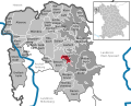 Waldaschaff in AB.svg 610 × 492; 621 KB
-
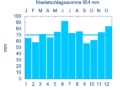 WALDASCHAFF nieder.png 480 × 360; 5 KB
-
 WALDASCHAFF nieder.svg 512 × 427; 21 KB
-
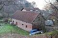 Waldaschaff, Am Seehaus 2 Side Building.jpg 5,400 × 3,600; 19.72 MB
-
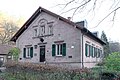 Waldaschaff, Am Seehaus 2.jpg 5,400 × 3,600; 15.29 MB


