Category:Wantage
market town and civil parish in Vale of White Horse, Oxfordshire, England  | |||||
| Upload media | |||||
| Instance of | |||||
|---|---|---|---|---|---|
| Location | Vale of White Horse, Oxfordshire, South East England, England | ||||
| Said to be the same as | Wantage (Wikimedia duplicated page, civil parish) | ||||
| official website | |||||
 | |||||
Main Wikipedia article: Wantage.
Subcategories
This category has the following 10 subcategories, out of 10 total.
Media in category "Wantage"
The following 200 files are in this category, out of 507 total.
(previous page) (next page)-
 A jumble of stones - geograph.org.uk - 2471842.jpg 600 × 800; 230 KB
-
 A new footpath - geograph.org.uk - 2568416.jpg 1,024 × 768; 335 KB
-
 A New Road Junction - geograph.org.uk - 6141181.jpg 5,214 × 2,962; 1.66 MB
-
 A True Son - geograph.org.uk - 5211650.jpg 600 × 800; 149 KB
-
 A338 at Grove village boundary - geograph.org.uk - 3130921.jpg 640 × 480; 61 KB
-
 A417 at East Challow boundary sign - geograph.org.uk - 3131363.jpg 640 × 480; 85 KB
-
 A417 at Grove Park - geograph.org.uk - 3130928.jpg 640 × 480; 50 KB
-
 A417 at Wantage boundary - geograph.org.uk - 3130005.jpg 640 × 480; 74 KB
-
 A417 from Wantage - geograph.org.uk - 113732.jpg 640 × 481; 41 KB
-
 AEC Regent III PWL OxfordParkway RearAdvert.jpg 915 × 1,280; 488 KB
-
-
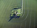
 Aerial View West Wantage.jpg 6,000 × 4,000; 7.72 MB
-
 Aircraftsman A.H.Anns - geograph.org.uk - 5210669.jpg 600 × 800; 112 KB
-
 Alma Drill Hall, Springfield Road - geograph.org.uk - 3228407.jpg 1,024 × 683; 145 KB
-
 An overgrown part - geograph.org.uk - 5210665.jpg 1,024 × 768; 292 KB
-
 Arable field on The Ridgeway - geograph.org.uk - 1395715.jpg 640 × 427; 65 KB
-
 Arable land north of The Ridgeway - geograph.org.uk - 1395722.jpg 640 × 427; 71 KB
-
 Arbery arcade - geograph.org.uk - 1191008.jpg 640 × 426; 59 KB
-
 Arch in the Wall - geograph.org.uk - 5216914.jpg 600 × 800; 137 KB
-
 ATS Euromaster, 76 Grove Street, Wantage - geograph.org.uk - 3051852.jpg 1,024 × 675; 167 KB
-
 B4494 (Chain Hill Road) junction with Ormond Road - geograph.org.uk - 3040990.jpg 3,566 × 2,675; 1.44 MB
-
 B4494 (Chainhill Road) climbs towards Chainhill Farm - geograph.org.uk - 3040906.jpg 3,495 × 2,658; 1.17 MB
-
 B4494 passes reservoir on the summit of Chain Hill - geograph.org.uk - 3040954.jpg 3,648 × 2,606; 1.8 MB
-
 B4507 Ickeleton Road west of Wantage - geograph.org.uk - 2917482.jpg 1,024 × 683; 237 KB
-
 Back of the post office - geograph.org.uk - 1886007.jpg 1,024 × 768; 143 KB
-
 Back to the ford - geograph.org.uk - 2471814.jpg 1,024 × 768; 303 KB
-
 Beams in the arcade - geograph.org.uk - 1191135.jpg 400 × 600; 46 KB
-
 Bell over the clock - geograph.org.uk - 2035479.jpg 1,024 × 768; 184 KB
-
 Belmont, Wantage - geograph.org.uk - 6099734.jpg 1,920 × 1,280; 1.44 MB
-

-

-
 Benchmark on 4 Eblands Place, Challow Road - geograph.org.uk - 2916284.jpg 683 × 1,024; 311 KB
-
 Benchmark on bottom step to Parish Hall - geograph.org.uk - 2380328.jpg 683 × 1,024; 227 KB
-
 Benchmark on buttress of SS Peter ^ Paul Church - geograph.org.uk - 2628368.jpg 683 × 1,024; 267 KB
-
 Benchmark on Chain Hill Cottage - geograph.org.uk - 2943169.jpg 683 × 1,024; 277 KB
-

-
 Benchmark on Holy Trinity Church - geograph.org.uk - 2380271.jpg 533 × 800; 210 KB
-
 Benchmark on Ivy Bank, Portway - geograph.org.uk - 2395236.jpg 683 × 1,024; 210 KB
-
 Benchmark on New Barn, south side of A417 - geograph.org.uk - 2380230.jpg 1,024 × 683; 266 KB
-
 Benchmark on parapet of bridge on Ickleton Road - geograph.org.uk - 2382503.jpg 1,024 × 683; 266 KB
-
 Benchmark on the doorstep of ^21 Harcourt Green - geograph.org.uk - 3793219.jpg 1,024 × 683; 284 KB
-

-

-
 Benchmark on wall in front of ^32 Charlton Road - geograph.org.uk - 2394507.jpg 683 × 1,024; 237 KB
-
 Benchmark on ^12 Newbury Street - geograph.org.uk - 3226829.jpg 683 × 1,024; 275 KB
-
 Benchmark on ^15 Naldertown - geograph.org.uk - 2382129.jpg 683 × 1,024; 263 KB
-
 Benchmark on ^20 Courtenay Road - geograph.org.uk - 3793322.jpg 678 × 1,024; 193 KB
-
 Benchmark on ^31 Springfield Road - geograph.org.uk - 2942228.jpg 683 × 1,024; 203 KB
-
 Benchmark on ^36 Orchard Way - geograph.org.uk - 2942309.jpg 683 × 1,024; 214 KB
-
 Benchmark on ^40 Harcourt Road - geograph.org.uk - 3793185.jpg 683 × 1,024; 258 KB
-
 Benchmark on ^54 Charlton Road - geograph.org.uk - 2383185.jpg 683 × 1,024; 239 KB
-
 Benchmark on ^87 Springfield Road - geograph.org.uk - 2942210.jpg 683 × 1,024; 345 KB
-
 Bend on Ickleton Road - geograph.org.uk - 2568463.jpg 1,024 × 768; 294 KB
-
 Betjeman Lane - geograph.org.uk - 4050336.jpg 480 × 640; 545 KB
-
 Betjeman Lane, Wantage - geograph.org.uk - 2858173.jpg 476 × 640; 90 KB
-
 Betjeman Millennium park pillar - geograph.org.uk - 2474644.jpg 600 × 800; 156 KB
-
 Biking along the path - geograph.org.uk - 1640877.jpg 640 × 480; 109 KB
-
 Bit of a clue - geograph.org.uk - 2271344.jpg 600 × 800; 117 KB
-
 Blue Boar - geograph.org.uk - 5216892.jpg 1,024 × 768; 142 KB
-
 Blue Door - geograph.org.uk - 5216917.jpg 600 × 800; 131 KB
-
 Bonus point - geograph.org.uk - 2571075.jpg 600 × 800; 158 KB
-
 BP garage on Wallingford Street, Wantage - geograph.org.uk - 5956444.jpg 1,920 × 1,280; 1.27 MB
-
 Brass on the Pillar - geograph.org.uk - 4342121.jpg 533 × 800; 68 KB
-
 Brass on the Wall - geograph.org.uk - 4340981.jpg 533 × 800; 56 KB
-
 Bridge on the brook - geograph.org.uk - 2565145.jpg 1,024 × 768; 316 KB
-
 Broken Cross - geograph.org.uk - 5210588.jpg 1,024 × 768; 256 KB
-
 Broken Pillar - geograph.org.uk - 5211572.jpg 1,024 × 768; 266 KB
-
 Bryan Way, Charlton, Wantage - geograph.org.uk - 2678690.jpg 640 × 480; 104 KB
-
 Building Site east of Wantage - geograph.org.uk - 6141178.jpg 4,581 × 2,449; 1.37 MB
-
 Buildings at Manor Farm beside A338 - geograph.org.uk - 2941512.jpg 1,024 × 683; 256 KB
-
 Bulrushes on the edge - geograph.org.uk - 1640856.jpg 480 × 640; 120 KB
-
 Car wash and motor sales, Grove Road, Wantage - geograph.org.uk - 5875245.jpg 1,600 × 1,200; 658 KB
-
 Carving on the chapel - geograph.org.uk - 1886027.jpg 600 × 800; 158 KB
-
 Carving under the window - geograph.org.uk - 1886077.jpg 600 × 800; 124 KB
-
 Cemetery entrance, Chainhill Road - geograph.org.uk - 2942731.jpg 1,024 × 683; 236 KB
-
 Cemetery path - geograph.org.uk - 5209662.jpg 1,024 × 768; 227 KB
-
 Chain Hill Cemetery in Wantage - geograph.org.uk - 2483129.jpg 1,500 × 1,000; 144 KB
-
 Chain hill Wantage - geograph.org.uk - 1890605.jpg 600 × 800; 92 KB
-
 Chainhill Road (B4494) - geograph.org.uk - 2940822.jpg 1,024 × 683; 155 KB
-
 Chainhill Road Reservoir - geograph.org.uk - 2483155.jpg 1,500 × 1,000; 144 KB
-
 Chainhill Road to Wantage - geograph.org.uk - 2483148.jpg 1,500 × 1,000; 186 KB
-
 Chainhill Road to Wantage - geograph.org.uk - 2483173.jpg 1,500 × 1,000; 136 KB
-
 Change of Use - geograph.org.uk - 5216906.jpg 1,024 × 768; 162 KB
-
 Chapel at St Mary's - geograph.org.uk - 1886045.jpg 1,024 × 768; 159 KB
-
 Chapel for sale - geograph.org.uk - 1886020.jpg 600 × 800; 105 KB
-
 Charlton Park garden centre - geograph.org.uk - 5956667.jpg 1,920 × 1,280; 1,000 KB
-
 Charlton Road-Garston Road junction - geograph.org.uk - 3130917.jpg 640 × 480; 70 KB
-
 Church road - geograph.org.uk - 2562797.jpg 1,024 × 768; 234 KB
-
 Church steps, Wantage - geograph.org.uk - 2858160.jpg 640 × 480; 122 KB
-
 Commemorative Plaque - geograph.org.uk - 4342468.jpg 533 × 800; 71 KB
-
 Concrete and fence - geograph.org.uk - 1640868.jpg 640 × 480; 154 KB
-
 Cones along the street - geograph.org.uk - 1191031.jpg 400 × 600; 51 KB
-
 Considerate Dog Owner, I think not^ - geograph.org.uk - 2566808.jpg 600 × 800; 176 KB
-
 Coo^ He's a bit low^ - geograph.org.uk - 3041026.jpg 2,916 × 2,101; 1.46 MB
-
 Corner of the building - geograph.org.uk - 1890601.jpg 1,024 × 768; 166 KB
-
 Cover of the font - geograph.org.uk - 2035235.jpg 600 × 800; 81 KB
-
 Cowslips on bank beside Charlton Village Road - geograph.org.uk - 2387260.jpg 1,024 × 683; 207 KB
-
 Crabhill Lane - geograph.org.uk - 5650436.jpg 640 × 480; 104 KB
-
 Creeping Ivy - geograph.org.uk - 5211580.jpg 1,024 × 768; 260 KB
-
 Cross in the Grass - geograph.org.uk - 5210667.jpg 1,024 × 768; 303 KB
-
 Cross on the Ground - geograph.org.uk - 5211645.jpg 600 × 800; 147 KB
-
 Cross on the roof - geograph.org.uk - 1886037.jpg 600 × 800; 45 KB
-
 Cross on the wall - geograph.org.uk - 1885968.jpg 600 × 800; 147 KB
-
 Crossroads and sign for West Lockinge - geograph.org.uk - 5873798.jpg 1,600 × 1,001; 569 KB
-

-
 Daba Kymonic.jpg 2,000 × 2,000; 1.37 MB
-
 Daffodils in the Churchyard, Wantage - geograph.org.uk - 5217242.jpg 640 × 480; 161 KB
-
 Dancing at The Lamb - geograph.org.uk - 2553598.jpg 1,600 × 936; 333 KB
-
 Dangerous section - geograph.org.uk - 2567134.jpg 1,024 × 768; 287 KB
-
 Deli on the Corner - geograph.org.uk - 5216898.jpg 1,024 × 768; 151 KB
-

-
 Dental Practice - geograph.org.uk - 5216890.jpg 600 × 800; 102 KB
-
 Devil's Punchbowl - panoramio (4).jpg 3,072 × 2,304; 2.87 MB
-
 Dovecot in the roof - geograph.org.uk - 2035552.jpg 1,024 × 768; 237 KB
-
 Dovecote by the arch - geograph.org.uk - 2035567.jpg 1,024 × 768; 186 KB
-
 Downs Museum - geograph.org.uk - 1885999.jpg 1,024 × 768; 158 KB
-
 Ducks in the Brook - geograph.org.uk - 2271261.jpg 1,024 × 768; 232 KB
-
 End of Ormond Road, Wantage, Oxon.jpg 1,024 × 768; 187 KB
-
 End of restricted byway across Furzewick Down - geograph.org.uk - 2941062.jpg 683 × 1,024; 210 KB
-
 End of the spur - geograph.org.uk - 1209902.jpg 640 × 426; 101 KB
-
 End of the spur - geograph.org.uk - 1210029.jpg 640 × 426; 48 KB
-
 Entrance to Alfredsons place - geograph.org.uk - 1884587.jpg 600 × 800; 110 KB
-

-
 Entrance to Manor Farm Business Park - geograph.org.uk - 5875260.jpg 1,600 × 891; 561 KB
-
 Entrance to Portway - geograph.org.uk - 1191057.jpg 640 × 426; 69 KB
-
 Entrance to the school - geograph.org.uk - 1885959.jpg 480 × 640; 96 KB
-
 F.K.Harris - geograph.org.uk - 5210737.jpg 600 × 800; 115 KB
-
 Family Vault - geograph.org.uk - 5211576.jpg 1,024 × 768; 243 KB
-
 Farmland, Wantage - geograph.org.uk - 1571044.jpg 640 × 480; 157 KB
-
 Farmland, Wantage - geograph.org.uk - 2678759.jpg 640 × 480; 121 KB
-
 Farmland, Wantage - geograph.org.uk - 6190610.jpg 1,024 × 683; 270 KB
-
 Farmland, Wantage - geograph.org.uk - 6190612.jpg 1,024 × 683; 233 KB
-
 Fence across the entrance - geograph.org.uk - 1890589.jpg 1,024 × 768; 201 KB
-
 Fence by the playing field - geograph.org.uk - 2566804.jpg 600 × 800; 201 KB
-
 Field Barn - geograph.org.uk - 2483423.jpg 1,500 × 1,000; 143 KB
-
 Field Barn - geograph.org.uk - 4190625.jpg 1,024 × 600; 93 KB
-
 Field of oil seed rape - geograph.org.uk - 3906062.jpg 640 × 480; 72 KB
-
 Finished building - geograph.org.uk - 2562763.jpg 1,024 × 789; 140 KB
-
 Flats on Limborough Road, Wantage - geograph.org.uk - 5956426.jpg 1,858 × 1,228; 1.21 MB
-
 Flight Lieutenant E.W.Carmichael - geograph.org.uk - 5211570.jpg 600 × 800; 112 KB
-
 Flight Sergeant A.J.Ackers - geograph.org.uk - 5210739.jpg 600 × 800; 115 KB
-
 Floral Display - geograph.org.uk - 4341168.jpg 533 × 800; 119 KB
-
 Flowers by the Madonna - geograph.org.uk - 4343554.jpg 533 × 800; 112 KB
-
 Font with a cover - geograph.org.uk - 2035223.jpg 600 × 800; 67 KB
-
 Font ^ Cover - geograph.org.uk - 4340719.jpg 533 × 800; 68 KB
-
 Footbridge over the Letcombe Brook - geograph.org.uk - 1748352.jpg 2,000 × 3,008; 2.37 MB
-
 Footbridge over the mill stream, Wantage - geograph.org.uk - 5217257.jpg 3,264 × 2,448; 2.52 MB
-
 Footpath - geograph.org.uk - 3906060.jpg 640 × 480; 107 KB
-
 Footpath across the road - geograph.org.uk - 2567141.jpg 1,024 × 768; 224 KB
-
 Footpath beside the hospital - geograph.org.uk - 2035710.jpg 1,024 × 768; 182 KB
-
 Footpath by Letcombe brook - geograph.org.uk - 2474661.jpg 1,024 × 768; 268 KB
-
 Footpath on Ormond Road - geograph.org.uk - 2035679.jpg 600 × 800; 128 KB
-
 Footpath to the archway - geograph.org.uk - 2035580.jpg 600 × 800; 165 KB
-
 Ford at Wantage - geograph.org.uk - 3389584.jpg 3,872 × 2,592; 2.34 MB
-
 Ford on Letcombe Brook - geograph.org.uk - 2568411.jpg 1,024 × 768; 341 KB
-
 Ford on Locks Lane - geograph.org.uk - 2470313.jpg 1,024 × 768; 329 KB
-
 Forgotten Headstones - geograph.org.uk - 5210581.jpg 1,024 × 768; 269 KB
-
 Fork in the road - geograph.org.uk - 2035597.jpg 1,024 × 768; 164 KB
-
 Former Wantage UDC (Council) Offices, Portway, Wantage, Oxon.jpg 931 × 622; 176 KB
-
 From over the road - geograph.org.uk - 2271281.jpg 1,024 × 768; 154 KB
-
 From the top of Wantage Civic Hall - geograph.org.uk - 3403873.jpg 2,560 × 1,920; 1.09 MB
-
 From the Towpath - geograph.org.uk - 2271293.jpg 1,024 × 768; 194 KB
-
 Furzewick Farm from track towards the A338 - geograph.org.uk - 2941109.jpg 1,024 × 683; 267 KB
-
 Garston Lane School - geograph.org.uk - 2474684.jpg 2,181 × 1,000; 302 KB
-
 Gate to a field - geograph.org.uk - 2565149.jpg 1,024 × 768; 323 KB
-
 Gravestones in Chain Hill Cemetery - geograph.org.uk - 2483131.jpg 1,500 × 1,000; 248 KB
-
 Grove Road in Wantage - geograph.org.uk - 1770963.jpg 1,500 × 962; 222 KB
-

-
 Grove Street to the right - geograph.org.uk - 2035509.jpg 1,024 × 768; 240 KB
-

-
 Grove Street, Wantage - geograph.org.uk - 3052929.jpg 1,024 × 656; 209 KB
-
 Grove Street, Wantage - geograph.org.uk - 5065698.jpg 768 × 1,024; 189 KB
-
 Growing under Nets - geograph.org.uk - 5462106.jpg 1,600 × 1,067; 700 KB
-
 Gunner W.G.Kelly - geograph.org.uk - 5211575.jpg 600 × 800; 140 KB
-
 Hairdressers on Mill Street - geograph.org.uk - 2271320.jpg 600 × 800; 116 KB
-
 Hall by the priory - geograph.org.uk - 2470243.jpg 1,024 × 768; 184 KB
-
 Harcourt Road - geograph.org.uk - 5650445.jpg 640 × 480; 94 KB
-
 Heading up Round Hill - geograph.org.uk - 5650460.jpg 640 × 480; 89 KB
-
 Headstone in the shrubbery - geograph.org.uk - 5211787.jpg 600 × 800; 152 KB
-
 Headstones by the Path - geograph.org.uk - 5210584.jpg 1,024 × 768; 241 KB
-
 Hedge between two wheat fields - geograph.org.uk - 2925495.jpg 1,024 × 683; 186 KB
-
 Hedges by Grove Road - geograph.org.uk - 6103157.jpg 1,882 × 1,220; 1.25 MB
-
 Holy Trinity Church Charlton - geograph.org.uk - 3906058.jpg 640 × 480; 85 KB
-
 Hospital car park - geograph.org.uk - 2035620.jpg 1,024 × 768; 171 KB
-
 Hospital sign - geograph.org.uk - 2035641.jpg 1,024 × 768; 196 KB
-
 House by the basin - geograph.org.uk - 1211343.jpg 640 × 426; 53 KB
-
 Houses in Ormond Road, Wantage - geograph.org.uk - 5875252.jpg 1,600 × 1,200; 796 KB
-
 Houses on Denchworth Road, Wantage - geograph.org.uk - 6099732.jpg 1,920 × 1,280; 1.76 MB
-
 Houses on Manor Road - geograph.org.uk - 5462116.jpg 1,600 × 1,026; 364 KB
-
 Housing by the chapel - geograph.org.uk - 1890582.jpg 1,024 × 768; 172 KB
-
 Housing development, Oxford Road, Wantage - geograph.org.uk - 5873796.jpg 1,600 × 800; 449 KB
-
 Ickleton Road Bridge - geograph.org.uk - 2570864.jpg 1,024 × 768; 310 KB
-
 Ickleton Road bridge - geograph.org.uk - 2577233.jpg 1,024 × 768; 252 KB
-
 Icknield lane - geograph.org.uk - 2035709.jpg 600 × 800; 153 KB
-
 Icknield Way Morris Men.jpg 3,888 × 2,592; 641 KB
-
 In a meadow near here - geograph.org.uk - 2570876.jpg 1,024 × 768; 334 KB
-
 Information by the entrance - geograph.org.uk - 1191068.jpg 400 × 600; 63 KB
-
 Information on Sir William - geograph.org.uk - 4342364.jpg 1,024 × 683; 69 KB
-
 Information pillar - geograph.org.uk - 2471887.jpg 600 × 800; 177 KB
-
 Inscription around the base - geograph.org.uk - 5210662.jpg 600 × 800; 124 KB


_junction_with_Ormond_Road_-_geograph.org.uk_-_3040990.jpg)
_climbs_towards_Chainhill_Farm_-_geograph.org.uk_-_3040906.jpg)


_-_geograph.org.uk_-_2940822.jpg)


.jpg)


_Offices,_Portway,_Wantage,_Oxon.jpg)


