Category:Wavertree lockup
| Object location | | View all coordinates using: OpenStreetMap |
|---|
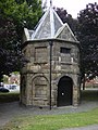
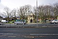
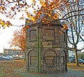
grade II listed lockup in Liverpool    | |||||
| Upload media | |||||
| Instance of | |||||
|---|---|---|---|---|---|
| Location | |||||
| Heritage designation |
| ||||
 | |||||
Subcategories
This category has the following 2 subcategories, out of 2 total.
I
- Interior of Wavertree lockup (4 F)
W
- Wavertree lockup plaque (2 F)
Media in category "Wavertree lockup"
The following 12 files are in this category, out of 12 total.
-
 Lock up, Childwall Road, Wavertree 2010.jpg 2,304 × 3,072; 1.15 MB
-
 Wavertree lock-up (1).JPG 3,456 × 4,608; 3.5 MB
-
 Wavertree lock-up (2).JPG 3,456 × 4,608; 3.48 MB
-
 Wavertree Lock-up - geograph.org.uk - 2855561.jpg 480 × 640; 123 KB
-
 Wavertree Lock-up - geograph.org.uk - 39230.jpg 480 × 640; 60 KB
-
 Wavertree lock-up - geograph.org.uk - 4278479.jpg 4,339 × 2,359; 6.32 MB
-
 Wavertree Lock-up - geograph.org.uk - 4379230.jpg 6,000 × 4,000; 4.32 MB
-
 Wavertree lockup 1.jpg 4,941 × 3,843; 18.45 MB
-
 Wavertree lockup 2.jpg 3,928 × 3,552; 8.43 MB
-
 Wavertree lockup 3.jpg 4,408 × 3,504; 9.65 MB
-
 Wavertree lockup 4.jpg 4,448 × 3,664; 11.18 MB
-
 Wavertree lockup, Heritage Open Day 2019.jpg 4,419 × 3,396; 10.45 MB

.JPG)
.JPG)


