Category:Wayside Shrine in der Kehr (Deidesheim)
| Object location | | View all coordinates using: OpenStreetMap |
|---|

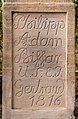
Wayside shrine northwest the settlement at a crossroad at In der Kehr.
- Tuscan column with post-baroque attachment, yellow sandstone, identified by 1816.
Media in category "Wayside Shrine in der Kehr (Deidesheim)"
The following 3 files are in this category, out of 3 total.
-
 003 2015 09 26 Kulturdenkmaeler Deidesheim.jpg 2,774 × 1,802; 5.37 MB
-
 005 2015 09 26 Kulturdenkmaeler Deidesheim.jpg 1,402 × 3,566; 4.95 MB
-
 006 2015 09 26 Kulturdenkmaeler Deidesheim.jpg 1,808 × 2,766; 5.17 MB

