Category:Wehrbrücke Augst/Wyhlen
| Object location | | View all coordinates using: OpenStreetMap |
|---|
 | |||||
| Upload media | |||||
| Instance of | |||||
|---|---|---|---|---|---|
| Part of | |||||
| Location |
| ||||
| Architect | |||||
| Inception |
| ||||
| Elevation above sea level |
| ||||
 | |||||
Media in category "Wehrbrücke Augst/Wyhlen"
The following 13 files are in this category, out of 13 total.
-
 Kabelbruecke Wyhlen 01 11.jpg 1,575 × 1,049; 629 KB
-
 Wasserkraftwerk Wyhlen, Stauwehr.jpg 3,968 × 2,976; 7.56 MB
-
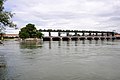 Wehrbruecke Augst-Wyhlen 01 11.jpg 1,575 × 1,049; 586 KB
-
 Wehrbruecke Augst-Wyhlen 01 11.png 2,585 × 1,548; 1.18 MB
-
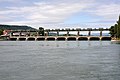
 Wehrbruecke Augst-Wyhlen 02 11.jpg 1,575 × 1,049; 832 KB
-
 Wehrbruecke Augst-Wyhlen 03 11.jpg 1,575 × 1,049; 520 KB
-
 Wehrbruecke Augst-Wyhlen 04 11.jpg 1,575 × 1,049; 698 KB
-
 Wehrbruecke Augst-Wyhlen 05 11.jpg 1,575 × 1,049; 781 KB
-
 Wehrbruecke Augst-Wyhlen 06 11.jpg 1,575 × 1,049; 963 KB
-
 Wehrbruecke Augst-Wyhlen 07 11.jpg 1,575 × 1,049; 835 KB
-
 Wehrbruecke Augst-Wyhlen 08 11.jpg 1,575 × 1,049; 648 KB
-
 Wehrbruecke Augst-Wyhlen 09 11.jpg 1,575 × 1,049; 730 KB
-
 Wehrbruecke Augst-Wyhlen 10 11.jpg 1,575 × 1,049; 852 KB


