Category:Weißplatte (Rätikon)
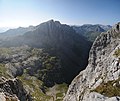
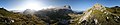
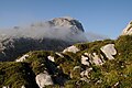
Deutsch: Die Weißplatte, auch genannt Wiss Platte, ist ein nach österreichischen Angaben 2.630 m, nach schweizerischen 2.628 m hoher Berg im Rätikon, einer Gebirgsgruppe der westlichen Zentralalpen. Der Gipfel liegt genau auf der Staatsgrenze zwischen dem österreichischen Bundesland Vorarlberg und dem Schweizer Kanton Graubünden. Die Weißplatte gehört zur Sulzfluhgruppe.
| Object location | | View all coordinates using: OpenStreetMap |
|---|
mountain in the Rätikon at the border Vorarlberg / Grisons  | |||||
| Upload media | |||||
| Instance of | |||||
|---|---|---|---|---|---|
| Location |
| ||||
| Mountain range | |||||
| Topographic prominence |
| ||||
| Topographic isolation |
| ||||
| Elevation above sea level |
| ||||
| Parent peak | |||||
 | |||||
Media in category "Weißplatte (Rätikon)"
The following 6 files are in this category, out of 6 total.
-
 Sulzfluhplateau Weißplatte.JPG 4,288 × 2,848; 3.14 MB
-
 Weißplatte 3.JPG 4,288 × 2,848; 6.43 MB
-
 Weißplatte Panorama 1.jpg 3,608 × 3,025; 8.14 MB
-
 Weißplatte Panorama 2.jpg 10,200 × 2,111; 17.68 MB
-
 Weißplatte Panorama.jpg 5,070 × 2,673; 12.31 MB
-
 Weißplatte.JPG 4,288 × 2,848; 6.36 MB


