Category:Wemyss, Fife
Scottish parish in Fife, Scotland, UK | |||||
| Upload media | |||||
| Instance of | |||||
|---|---|---|---|---|---|
| Location |
| ||||
| Population |
| ||||
| Area |
| ||||
 | |||||
Subcategories
This category has the following 5 subcategories, out of 5 total.
B
C
E
M
W
Media in category "Wemyss, Fife"
The following 200 files are in this category, out of 446 total.
(previous page) (next page)-
 'The Braes,' Buckhaven - geograph.org.uk - 5540312.jpg 4,512 × 2,878; 3.96 MB
-
 A boulder-mounted plaque, East Wemyss - geograph.org.uk - 3989302.jpg 4,608 × 3,456; 3.05 MB
-
 A glimpse of Wemyss Castle - geograph.org.uk - 3989063.jpg 4,608 × 3,456; 3.25 MB
-
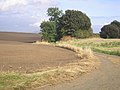
 A junction on the Fife Coastal Path - geograph.org.uk - 4192447.jpg 2,816 × 2,112; 1,013 KB
-

-
 A raft of a dozen male Eider - geograph.org.uk - 3989035.jpg 4,608 × 3,456; 3.38 MB
-
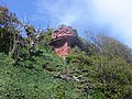 A red sandstone cliff-top tower - geograph.org.uk - 3989075.jpg 4,608 × 3,456; 3.06 MB
-
 A saltire at the entrance to West Wemyss harbour - geograph.org.uk - 3756970.jpg 1,024 × 682; 178 KB
-
 A955 at Bowhouse Cottages - geograph.org.uk - 4558214.jpg 640 × 480; 58 KB
-
 A955 between Muiredge and East Wemyss - geograph.org.uk - 6223290.jpg 1,632 × 1,224; 533 KB
-
 A955 by Rosie Cottages - geograph.org.uk - 6223296.jpg 1,469 × 1,102; 537 KB
-
 A955 eastbound at Aberhill - geograph.org.uk - 4558288.jpg 640 × 480; 71 KB
-

-

-
 A955 High Road, East Wemyss - geograph.org.uk - 4558266.jpg 640 × 482; 64 KB
-

-
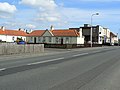
 A955 Main Road, Coaltown of Wemyss - geograph.org.uk - 4558240.jpg 640 × 481; 54 KB
-
 A955 Methilhaven Road into Muiredge - geograph.org.uk - 6223286.jpg 1,632 × 1,224; 523 KB
-
 A955 Methilhaven Road towards East Wemyss - geograph.org.uk - 6223288.jpg 1,632 × 1,224; 658 KB
-

-
 Abandoned caravan, Leven - geograph.org.uk - 5709837.jpg 2,715 × 1,999; 1.75 MB
-
 Access to the Hydrogen Office - geograph.org.uk - 2964183.jpg 2,048 × 1,536; 1,015 KB
-
 Accident damage to building in Lower Methil - geograph.org.uk - 5000962.jpg 4,608 × 3,060; 3.07 MB
-
 Allotments, West Wemyss - geograph.org.uk - 6161859.jpg 5,320 × 3,372; 4.71 MB
-
 Anderson Shelter on West Wynd, Buckhaven - geograph.org.uk - 6223243.jpg 1,632 × 1,224; 940 KB
-
 Anderson Shelter, Buckhaven - geograph.org.uk - 5540221.jpg 4,558 × 2,969; 3.94 MB
-
 Approaching Buckhaven - geograph.org.uk - 2963745.jpg 2,048 × 1,536; 504 KB
-
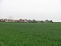
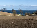
 Arable land, Coaltown of Wemyss - geograph.org.uk - 2968772.jpg 640 × 367; 192 KB
-
 Arable land, Coaltown of Wemyss - geograph.org.uk - 2970901.jpg 640 × 480; 248 KB
-
 Arable land, Lochhead - geograph.org.uk - 2968777.jpg 640 × 359; 205 KB
-
 Arable land, Woodbank - geograph.org.uk - 2968792.jpg 640 × 359; 182 KB
-
 As solid as a rock - geograph.org.uk - 2335942.jpg 2,560 × 1,920; 1.68 MB
-
 Ascent into Buckhaven - geograph.org.uk - 2963752.jpg 1,536 × 2,048; 1.09 MB
-
 Autumn in East Wemyss Den - geograph.org.uk - 6315568.jpg 640 × 427; 135 KB
-
 Bawbee Bridge, Leven - geograph.org.uk - 3047663.jpg 1,142 × 857; 301 KB
-
 Bawbee Bridge, Leven - geograph.org.uk - 6148078.jpg 5,726 × 3,384; 4.8 MB
-
 Bawbee Brig - geograph.org.uk - 2970062.jpg 2,048 × 1,536; 1.54 MB
-
 Bawbee filling station - geograph.org.uk - 3029373.jpg 1,142 × 857; 312 KB
-

-
 Bayview Stadium, Methil - geograph.org.uk - 3385689.jpg 4,320 × 3,240; 3.38 MB
-
 Beach between West Wemyss and Blair Point - geograph.org.uk - 6170749.jpg 1,600 × 1,067; 428 KB
-
 Belvedere Hotel, West Wemyss - geograph.org.uk - 6153287.jpg 5,323 × 3,272; 3.29 MB
-
 Belvedere Hotel, West Wemyss - geograph.org.uk - 6153302.jpg 5,167 × 3,059; 3 MB
-
 Belvedere Hotel, West Wemyss - geograph.org.uk - 6156889.jpg 5,617 × 3,745; 4.41 MB
-
 Bin day, Coaltown of Wemyss - geograph.org.uk - 2968768.jpg 640 × 359; 228 KB
-
 Blue crane - geograph.org.uk - 3935065.jpg 475 × 640; 246 KB
-
 Branxton Farm - geograph.org.uk - 2928798.jpg 1,200 × 900; 152 KB
-
 Bridge buttresses - geograph.org.uk - 6153213.jpg 4,658 × 3,286; 3.86 MB
-
 Broad Wynd, West Wemyss - geograph.org.uk - 6161953.jpg 5,840 × 3,498; 4.29 MB
-
 Broad Wynd, West Wemyss - geograph.org.uk - 6161965.jpg 5,923 × 3,583; 4.49 MB
-
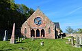 Buckhaven and Wemyss Parish Church - geograph.org.uk - 6161034.jpg 5,578 × 3,473; 3.22 MB
-
 Buckhaven and Wemyss Parish Church - geograph.org.uk - 6161048.jpg 4,718 × 3,252; 3.5 MB
-
 Buckhaven and Wemyss Parish Church - geograph.org.uk - 6161075.jpg 5,966 × 3,253; 3.42 MB
-
 Buckhaven and Wemyss Parish Church - geograph.org.uk - 6169653.jpg 1,600 × 1,086; 403 KB
-
 Buckhaven Bay, Fife - geograph.org.uk - 5540386.jpg 4,371 × 3,098; 3.56 MB
-
 Buckhaven Bay, Fife - geograph.org.uk - 5540427.jpg 4,608 × 2,944; 3.48 MB
-
 Buckhaven's old harbour - geograph.org.uk - 5540444.jpg 4,608 × 3,078; 3.43 MB
-
 Buckhaven's old harbour - geograph.org.uk - 5540453.jpg 4,608 × 3,103; 4.97 MB
-
 Buckhaven's old harbour - geograph.org.uk - 5540485.jpg 4,108 × 2,725; 2.78 MB
-
 Buckhaven's old harbour - geograph.org.uk - 5541833.jpg 4,371 × 2,868; 3.6 MB
-
 Buildings in Methilhill - geograph.org.uk - 4637704.jpg 4,608 × 3,456; 7.39 MB
-
 Buried Buckhaven^ - geograph.org.uk - 5927313.jpg 6,000 × 3,248; 4.09 MB
-
 Burn Mill Dam, Kirkland - geograph.org.uk - 6315564.jpg 640 × 427; 58 KB
-
 Burns Wynd, West Wemyss - geograph.org.uk - 6157699.jpg 5,684 × 3,717; 4.9 MB
-
 Burntisland Fabrications yard at Methil - geograph.org.uk - 5702998.jpg 4,608 × 3,036; 3.77 MB
-
 Bus stop, Wellesley Road - geograph.org.uk - 3284364.jpg 640 × 480; 294 KB
-
 Car park, West Wemyss - geograph.org.uk - 6161621.jpg 6,000 × 4,000; 7.47 MB
-
 Car park, West Wemyss - geograph.org.uk - 6161630.jpg 5,951 × 3,085; 2.37 MB
-
 Car wash - geograph.org.uk - 5764420.jpg 5,558 × 3,441; 4.42 MB
-
 Carpet warehouse - geograph.org.uk - 2963767.jpg 2,048 × 1,536; 1.43 MB
-
 Cattle in a field south of Percival Farm - geograph.org.uk - 6223291.jpg 1,632 × 1,224; 532 KB
-
 Cattle, Percival - geograph.org.uk - 2970861.jpg 640 × 480; 208 KB
-
 Children's playpark - geograph.org.uk - 6157748.jpg 5,437 × 3,583; 3.65 MB
-
 Church Street, West Wemyss - geograph.org.uk - 6161923.jpg 5,486 × 3,458; 4.53 MB
-
 Church Street, West Wemyss - geograph.org.uk - 6161943.jpg 5,388 × 3,353; 3.35 MB
-
 Clamped car - geograph.org.uk - 6125341.jpg 4,477 × 2,663; 3.29 MB
-
 Clear up in progress - geograph.org.uk - 3925645.jpg 2,304 × 1,728; 768 KB
-
 Clothing bank - geograph.org.uk - 6092295.jpg 5,122 × 3,537; 3.42 MB
-
 Coast at East Wemyss - geograph.org.uk - 4292518.jpg 640 × 480; 53 KB
-
 Coastal concrete - geograph.org.uk - 2963295.jpg 2,048 × 1,536; 746 KB
-
 Coastal path approaching West Wemyss harbour - geograph.org.uk - 4192395.jpg 2,816 × 2,112; 1.3 MB
-
 Coastal walkers - geograph.org.uk - 5336979.jpg 2,560 × 1,920; 1.52 MB
-
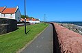
 Coastal wall - geograph.org.uk - 4192454.jpg 2,816 × 2,112; 1.12 MB
-
 Coastline behind Shore Street at Buckhaven - geograph.org.uk - 6223235.jpg 1,469 × 1,102; 508 KB
-
 Coloured concrete - geograph.org.uk - 2963878.jpg 2,048 × 1,536; 1.56 MB
-
 Community Pub, West Wemyss - geograph.org.uk - 6157717.jpg 5,126 × 3,431; 3.18 MB
-
 Cottage and tower - geograph.org.uk - 2335950.jpg 2,560 × 1,920; 1.07 MB
-
 Cottages on West Wynd, Buckhaven - geograph.org.uk - 6223249.jpg 1,632 × 1,224; 631 KB
-
 Court Cave, East Wemyss - geograph.org.uk - 5274521.jpg 1,200 × 1,600; 473 KB
-
 Cowley Street, Buckhaven - geograph.org.uk - 6092683.jpg 6,000 × 3,545; 3.82 MB
-
 Coxstool, West Wemyss - geograph.org.uk - 3385631.jpg 4,316 × 3,236; 5.23 MB
-
 Coxstool, West Wemyss - geograph.org.uk - 6153309.jpg 5,101 × 3,363; 2.56 MB
-
 Coxstool, West Wemyss - geograph.org.uk - 6162253.jpg 4,421 × 3,062; 2.26 MB
-
 Croftamorie, West Wemyss - geograph.org.uk - 6161846.jpg 5,483 × 3,231; 4.59 MB
-
 Croftamorie, West Wemyss - geograph.org.uk - 6161854.jpg 5,350 × 3,213; 4.16 MB
-
 Damage to wall - geograph.org.uk - 5841069.jpg 4,608 × 2,954; 3.12 MB
-
 Damaged breakwater, Methil - geograph.org.uk - 3701898.jpg 640 × 480; 59 KB
-
 Demolished Hall - geograph.org.uk - 3768537.jpg 640 × 480; 99 KB
-
 Demolition site - geograph.org.uk - 6092738.jpg 6,000 × 3,703; 3.2 MB
-
 Denbeath Parish Church - geograph.org.uk - 4984418.jpg 1,469 × 1,102; 524 KB
-
 Derelict house, Methil - geograph.org.uk - 6092755.jpg 5,756 × 3,474; 2.89 MB
-
 Disused mine workings - geograph.org.uk - 3409512.jpg 1,600 × 1,075; 133 KB
-
 Door and window mosaic, West Wemyss - geograph.org.uk - 6170252.jpg 1,600 × 1,050; 456 KB
-
 Duke Street, West Wemyss - geograph.org.uk - 6156879.jpg 5,677 × 3,543; 3.43 MB
-
 East Dock Bar, Methil - geograph.org.uk - 3701931.jpg 640 × 480; 73 KB
-
 East tower and part of wall, West Wemyss - geograph.org.uk - 6170306.jpg 1,600 × 1,067; 545 KB
-
 East Wemyss Bowling Club - geograph.org.uk - 6315569.jpg 640 × 427; 44 KB
-
 East Wemyss coastal defences - geograph.org.uk - 5985722.jpg 640 × 480; 81 KB
-
 East Wemyss slipway - geograph.org.uk - 2963360.jpg 1,903 × 1,450; 509 KB
-
 East Wemyss slipway - geograph.org.uk - 5985739.jpg 640 × 480; 58 KB
-
 East Wemyss War Memorial - geograph.org.uk - 4292991.jpg 478 × 640; 77 KB
-
 Electric vehicle charging point, Leven - geograph.org.uk - 5541826.jpg 3,873 × 2,801; 3.1 MB
-
 Entering Methilhill - geograph.org.uk - 6222045.jpg 1,469 × 1,102; 577 KB
-
 Entrance gate to churchyard, West Wemyss - geograph.org.uk - 6161068.jpg 5,658 × 3,641; 6.37 MB
-
 Entrance to Methil - geograph.org.uk - 3701857.jpg 640 × 480; 52 KB
-
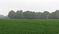
 Farmland near East Wemyss - geograph.org.uk - 3928062.jpg 640 × 480; 417 KB
-
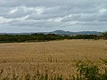 Field of wheat - geograph.org.uk - 3643156.jpg 2,048 × 1,536; 772 KB
-
 Field, Cowdenlaws - geograph.org.uk - 2972720.jpg 640 × 359; 195 KB
-
 Fife Coast at Buckhaven - geograph.org.uk - 3928080.jpg 640 × 461; 360 KB
-
 Fife coast at East Wemyss - geograph.org.uk - 3928048.jpg 640 × 480; 359 KB
-
 Fife coast between East and West Wemyss - geograph.org.uk - 3906372.jpg 640 × 427; 386 KB
-

-
 Fife coast near East Wemyss - geograph.org.uk - 3928039.jpg 640 × 474; 445 KB
-
 Fife Coastal Path - geograph.org.uk - 4192407.jpg 2,816 × 2,112; 1.24 MB
-
 Fife Coastal Path - geograph.org.uk - 4192425.jpg 2,816 × 2,112; 1.08 MB
-
 Fife Coastal Path - geograph.org.uk - 4200394.jpg 2,816 × 2,112; 1.08 MB
-
 Fife Coastal Path - geograph.org.uk - 4200411.jpg 2,816 × 2,112; 998 KB
-
 Fife Coastal Path - geograph.org.uk - 6096866.jpg 5,841 × 3,312; 2.55 MB
-
 Fife Coastal Path - geograph.org.uk - 6170858.jpg 1,600 × 1,054; 525 KB
-
 Fife Coastal Path and Wemyss Castle - geograph.org.uk - 4192431.jpg 2,816 × 2,112; 1.02 MB
-
 Fife Coastal Path approaches Macduff's Castle - geograph.org.uk - 4200400.jpg 2,816 × 2,112; 1.19 MB
-
 Fife Coastal Path at Buckhaven - geograph.org.uk - 3928072.jpg 640 × 480; 539 KB
-
 Fife Coastal Path at Viewforth - geograph.org.uk - 4200424.jpg 2,816 × 2,112; 1.39 MB
-
 Fife Coastal Path signpost - geograph.org.uk - 5985710.jpg 480 × 640; 108 KB
-
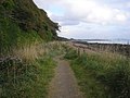
 Fife Coastal Path turns inland - geograph.org.uk - 4192509.jpg 2,816 × 2,112; 1.22 MB
-
 Fife coastal path, Buckhaven - geograph.org.uk - 5540327.jpg 3,456 × 4,346; 5.7 MB
-
 Fife Coastal Path, West Wemyss - geograph.org.uk - 6157723.jpg 5,848 × 3,756; 3.94 MB
-
 Fife Coastal Path, West Wemyss - geograph.org.uk - 6161004.jpg 5,386 × 3,585; 4.27 MB
-
 Fife Coastal Path, West Wemyss - geograph.org.uk - 6161676.jpg 5,643 × 3,406; 2.99 MB
-
 Fife Coastal Path, West Wemyss - geograph.org.uk - 6162309.jpg 5,365 × 3,112; 3.22 MB
-
 Fife College, Buckhaven - geograph.org.uk - 5540270.jpg 4,012 × 2,519; 2.05 MB
-
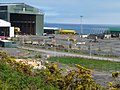 Fife Energy Park - geograph.org.uk - 2963833.jpg 2,048 × 1,536; 1.58 MB
-
 Fife Energy Park - geograph.org.uk - 5473360.jpg 4,034 × 2,519; 2.83 MB
-
 Fife Energy Park - geograph.org.uk - 5519964.jpg 1,600 × 1,200; 566 KB
-
 Fife Energy Park, Methil - geograph.org.uk - 5488668.jpg 3,872 × 2,592; 2.99 MB
-
 Fire damage to Denbeath Institute, Buckhaven - geograph.org.uk - 5505340.jpg 3,285 × 2,169; 1.76 MB
-
 Fire damage to Denbeath Miners' Institute, Buckhaven - geograph.org.uk - 5505345.jpg 4,027 × 2,911; 3.05 MB
-
 Fire engines - geograph.org.uk - 5875227.jpg 4,180 × 2,591; 3.34 MB
-
 Fisher Street, Methil - geograph.org.uk - 5841064.jpg 4,608 × 2,911; 3.14 MB
-
 Floral Arrangement - geograph.org.uk - 3681977.jpg 1,024 × 567; 167 KB
-
 Footpath to the A955 - geograph.org.uk - 4200418.jpg 2,816 × 2,112; 1.09 MB
-
 Foreshore at West Wemyss - geograph.org.uk - 6161078.jpg 5,576 × 3,636; 4.37 MB
-
 Former brick works, Buckhaven - geograph.org.uk - 6092715.jpg 5,977 × 3,599; 3.82 MB
-
 Former car park, Leven - geograph.org.uk - 5473372.jpg 4,230 × 2,490; 2.73 MB
-
 Former car park, Leven - geograph.org.uk - 5473384.jpg 4,249 × 2,825; 4.32 MB
-
 Former car park, Leven - geograph.org.uk - 5473391.jpg 4,366 × 2,749; 4.22 MB
-
 Former Drill Hall in East Wemyss - geograph.org.uk - 4292314.jpg 640 × 480; 52 KB
-
 Gas vent - geograph.org.uk - 2963336.jpg 2,048 × 1,536; 1.6 MB
-
 Gorse beside the sea - geograph.org.uk - 6122232.jpg 1,600 × 1,128; 426 KB
-
 Graves, MacDuff Cemetery - geograph.org.uk - 6122308.jpg 1,600 × 1,072; 407 KB
-
 Happies Close, West Wemyss - geograph.org.uk - 6157729.jpg 5,283 × 3,557; 3.46 MB
-
 Harbour, Methil - geograph.org.uk - 2970418.jpg 640 × 480; 315 KB
-
 Harbour, Methil - geograph.org.uk - 3701887.jpg 640 × 480; 57 KB
-
 Harbour, Methil - geograph.org.uk - 3701894.jpg 640 × 468; 54 KB
-
 Harbour, West Wemyss - geograph.org.uk - 3385610.jpg 4,314 × 3,232; 4.46 MB
-
 Health and safety notice, Methil - geograph.org.uk - 3284327.jpg 640 × 480; 259 KB
-
 High tide on the sea defences at Buckhaven - geograph.org.uk - 6223225.jpg 1,306 × 979; 441 KB
-
 High-rise in Methill - geograph.org.uk - 2963890.jpg 2,048 × 1,536; 1.49 MB
-
 Home improvements^ - geograph.org.uk - 5873981.jpg 5,591 × 3,342; 3.75 MB
-
 Horse-drawn funeral carriage - geograph.org.uk - 6307644.jpg 3,845 × 2,470; 2.59 MB
-
 Hotel name sign, West Wemyss - geograph.org.uk - 6153280.jpg 4,729 × 2,919; 3.55 MB
-
 Houses in East Wemyss - geograph.org.uk - 6096851.jpg 5,481 × 3,334; 2.74 MB
-
 Houses on Den Walk - geograph.org.uk - 4993698.jpg 1,469 × 1,102; 502 KB
-
 Industrial estate, Methil - geograph.org.uk - 3284317.jpg 640 × 480; 233 KB
-
 Information Board, 'The Braes', Buckhaven - geograph.org.uk - 5540293.jpg 4,002 × 2,476; 2.7 MB
-
 Information Board, 'The Braes', Buckhaven - geograph.org.uk - 5540396.jpg 4,608 × 3,093; 4.4 MB
-
 Innerleven - geograph.org.uk - 3935006.jpg 640 × 457; 321 KB
-
 Jimmy Shand memorial, East Wemyss - geograph.org.uk - 3392373.jpg 4,190 × 3,060; 4.69 MB
-
 Jimmy Shand Memorial, East Wemyss - geograph.org.uk - 6315572.jpg 640 × 427; 63 KB
-
 Kirkland Dental Practice - geograph.org.uk - 4993714.jpg 1,469 × 1,102; 554 KB
-
 Kirkland Gardens - geograph.org.uk - 3941092.jpg 1,600 × 1,200; 947 KB
-
 Kirkland High School, Methil - geograph.org.uk - 5513939.jpg 4,263 × 2,701; 2.75 MB
-
 Lane from Church Street, West Wemyss - geograph.org.uk - 6161920.jpg 3,725 × 5,266; 4.11 MB
-
 Leisure centre - geograph.org.uk - 2970074.jpg 2,048 × 1,536; 1.43 MB
-
 Leven beach - geograph.org.uk - 5764404.jpg 5,320 × 2,871; 2.84 MB
-
 Levenmouth Academy - geograph.org.uk - 5045982.jpg 4,608 × 3,456; 3.42 MB
-
 Levenmouth Academy - geograph.org.uk - 5045995.jpg 4,608 × 3,456; 3.35 MB
-
 Levenmouth Academy - geograph.org.uk - 5046008.jpg 4,608 × 3,456; 3.06 MB
-
 Links, Buckhaven - geograph.org.uk - 2970828.jpg 640 × 480; 242 KB
-
 Links, Buckhaven - geograph.org.uk - 2970839.jpg 640 × 480; 242 KB
-
 Lobster pots - geograph.org.uk - 2335945.jpg 1,920 × 2,560; 1.27 MB
-

-
 Lower Methill - geograph.org.uk - 2963895.jpg 2,048 × 1,536; 1.44 MB
-
 Macduff's Castle - geograph.org.uk - 4421579.jpg 640 × 480; 62 KB
-
 MacDuff's Castle - geograph.org.uk - 6122205.jpg 1,600 × 1,589; 585 KB
-
 Macduff's Castle, East Wemyss - geograph.org.uk - 5274507.jpg 1,600 × 1,200; 609 KB
-

-
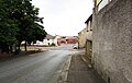
 Main Road, East Wemyss - geograph.org.uk - 2970889.jpg 640 × 480; 232 KB
-
 Main Street at West Wemyss - geograph.org.uk - 3234524.jpg 3,648 × 2,736; 644 KB
-
 Main Street, Methilhill - geograph.org.uk - 3941112.jpg 1,600 × 1,200; 578 KB


