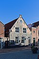
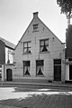
Category:Weststraat 3, Ouddorp
| Object location | | View all coordinates using: OpenStreetMap |
|---|
church building in Goeree-Overflakkee, Netherlands  | |||||
| Upload media | |||||
| Instance of | |||||
|---|---|---|---|---|---|
| Location | Ouddorp, Goeree-Overflakkee, South Holland, Netherlands | ||||
| Street address |
| ||||
| Located on street | |||||
| Heritage designation |
| ||||
| Inception |
| ||||
| Religion or worldview | |||||
 | |||||
|
This is a category about rijksmonument number 16263
|
Nederlands: Huis en Schuilkerk
| Address |
|
Media in category "Weststraat 3, Ouddorp"
The following 4 files are in this category, out of 4 total.
-
 Netherlands-Ouddorp-Weststraat-3.jpg 2,488 × 2,503; 658 KB
-
 Ouddorp Weststraat 3.jpg 4,008 × 6,008; 17.97 MB
-
 Overzicht - Ouddorp - 20178499 - RCE.jpg 1,200 × 962; 335 KB
-
 Voorgevel, Weststraat 3 - Ouddorp - 20178444 - RCE.jpg 805 × 1,200; 161 KB


