Category:Wheat fields in Buckinghamshire
Ceremonial counties of England: Bedfordshire · Berkshire · Buckinghamshire · Cambridgeshire · Cheshire · Cornwall · Devon · Dorset · East Riding of Yorkshire · East Sussex · Essex · Gloucestershire · Greater London · Hampshire · Herefordshire · Hertfordshire · Kent · Leicestershire · Lincolnshire · Merseyside · Norfolk · North Yorkshire · Northamptonshire · Northumberland · Nottinghamshire · Oxfordshire · Shropshire · Somerset · Staffordshire · Suffolk · Surrey · Warwickshire · West Sussex · West Yorkshire · Wiltshire · Worcestershire
City-counties:
Former historic counties:
Other former counties:
City-counties:
Former historic counties:
Other former counties:
Media in category "Wheat fields in Buckinghamshire"
The following 66 files are in this category, out of 66 total.
-

-
 Arable land below Mill Hanging Wood - geograph.org.uk - 1435655.jpg 640 × 427; 180 KB
-
 Below Gilham Copse - geograph.org.uk - 1435667.jpg 640 × 426; 183 KB
-
 Bridleway by wheat field - geograph.org.uk - 478797.jpg 640 × 480; 180 KB
-
 Bridleway cut between grass and wheat - geograph.org.uk - 478787.jpg 640 × 480; 212 KB
-
 Chiltern Way - geograph.org.uk - 1566000.jpg 640 × 480; 116 KB
-
 Dollar's Grove - geograph.org.uk - 438927.jpg 640 × 480; 110 KB
-
 Edge of Finemere Wood 2 - geograph.org.uk - 421442.jpg 640 × 480; 132 KB
-
 Edge of Finemere Wood 3 - geograph.org.uk - 936158.jpg 640 × 480; 142 KB
-
 Farmland in Buckinghamshire - geograph.org.uk - 397726.jpg 640 × 480; 87 KB
-
 Farmland with footpath near Cadmore End - geograph.org.uk - 1568857.jpg 640 × 480; 155 KB
-
 Farmland, Little Hampden - geograph.org.uk - 1556110.jpg 640 × 480; 131 KB
-
 Farmland, Little Marlow - geograph.org.uk - 902420.jpg 640 × 480; 108 KB
-
 Farmland, Little Marlow - geograph.org.uk - 902426.jpg 640 × 480; 116 KB
-
 Farmland, Little Marlow - geograph.org.uk - 902436.jpg 640 × 480; 132 KB
-
 Farmland, Little Marlow - geograph.org.uk - 902444.jpg 640 × 480; 126 KB
-
 Farmland, Little Marlow - geograph.org.uk - 902481.jpg 640 × 480; 124 KB
-
 Farmland, Little Marlow - geograph.org.uk - 902529.jpg 640 × 480; 152 KB
-
 Farmland, Piddington - geograph.org.uk - 768922.jpg 640 × 480; 163 KB
-
 Farmland, Piddington - geograph.org.uk - 768936.jpg 640 × 480; 135 KB
-
 Farmland, Piddington - geograph.org.uk - 769001.jpg 640 × 480; 140 KB
-
 Farmland, Radnage - geograph.org.uk - 883930.jpg 640 × 480; 136 KB
-
 Field entrance - geograph.org.uk - 904482.jpg 640 × 426; 89 KB
-
 Field of wheat - geograph.org.uk - 466693.jpg 640 × 480; 118 KB
-
 Fields - geograph.org.uk - 203633.jpg 640 × 480; 139 KB
-
 Fields by Benthill Farm - geograph.org.uk - 715523.jpg 640 × 425; 59 KB
-
 Fields near Shipton Lee - geograph.org.uk - 480064.jpg 640 × 480; 80 KB
-
 Fishing lake Quaker's Farm - geograph.org.uk - 439001.jpg 640 × 480; 98 KB
-
 Footpath - geograph.org.uk - 451108.jpg 640 × 480; 93 KB
-
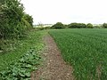 Footpath beside wheat field - geograph.org.uk - 433087.jpg 640 × 480; 244 KB
-
 Footpath junction near Runt's Wood - geograph.org.uk - 954685.jpg 640 × 480; 84 KB
-
 Footpath near Runt's Wood - geograph.org.uk - 956212.jpg 480 × 640; 109 KB
-
 Footpath near Shipton Lee - geograph.org.uk - 435740.jpg 640 × 480; 89 KB
-
 Footpath through wheat, Lower Winchendon - geograph.org.uk - 419308.jpg 480 × 640; 201 KB
-
 Footpath through wheat, Radnage - geograph.org.uk - 883928.jpg 640 × 480; 142 KB
-
 Footpath, Lower Woodend - geograph.org.uk - 976984.jpg 640 × 480; 151 KB
-

-
 North of Petsoe Manor farm - geograph.org.uk - 680675.jpg 640 × 480; 63 KB
-

-
 Path near to Walducks farm - geograph.org.uk - 475182.jpg 640 × 425; 83 KB
-

-
 Track and barn, Little Marlow - geograph.org.uk - 902527.jpg 640 × 480; 149 KB
-
 View from a Small Road - geograph.org.uk - 203608.jpg 640 × 480; 99 KB
-
 Wheat field - geograph.org.uk - 429667.jpg 640 × 480; 204 KB
-
 Wheat field - geograph.org.uk - 433063.jpg 640 × 480; 237 KB
-
 Wheat field - geograph.org.uk - 433538.jpg 640 × 480; 214 KB
-
 Wheat field by Silverstone circuit - geograph.org.uk - 478778.jpg 640 × 480; 188 KB
-
 Wheat field east of Hardwick - geograph.org.uk - 904480.jpg 640 × 426; 71 KB
-
 Wheat field near Groveway Farm - geograph.org.uk - 433066.jpg 640 × 480; 260 KB
-
 Wheat field near Ledburn - geograph.org.uk - 841387.jpg 640 × 340; 58 KB
-

-
 Wheat field with unplanted area - geograph.org.uk - 433058.jpg 640 × 480; 189 KB
-
 Wheat field, by Hanover Farm - geograph.org.uk - 437483.jpg 640 × 479; 163 KB
-
 Wheat field, Chesham Vale - geograph.org.uk - 189710.jpg 480 × 640; 105 KB
-
 Wheat, Little Marlow - geograph.org.uk - 902517.jpg 640 × 480; 124 KB
-
 Wheat, Stokenchurch - geograph.org.uk - 882128.jpg 640 × 480; 125 KB
-
 Wheat-20060629-014.jpg 3,031 × 2,006; 1.17 MB
-

-

-
 Wheatfield by the B482 - geograph.org.uk - 839294.jpg 640 × 480; 89 KB
-
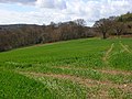
 Winter wheat - geograph.org.uk - 1129189.jpg 640 × 480; 78 KB
-
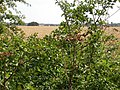
 Winter wheat near Flackwell Heath - geograph.org.uk - 719745.jpg 640 × 480; 230 KB
-
 Winter wheat on Flackwell Heath - geograph.org.uk - 117525.jpg 640 × 480; 243 KB
-
 Wheat field and hedge. - geograph.org.uk - 433081.jpg 640 × 480; 235 KB
-
 Wheat field and hedges - geograph.org.uk - 431227.jpg 640 × 480; 201 KB
-
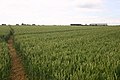
 Wheat field, view to Weedon - geograph.org.uk - 429709.jpg 640 × 480; 171 KB


