Category:Willemskerk, The Hague
| Object location | | View all coordinates using: OpenStreetMap |
|---|
church building in The Hague, Netherlands .jpg) | |||||
| Upload media | |||||
| Instance of | |||||
|---|---|---|---|---|---|
| Location | The Hague, South Holland, Netherlands | ||||
| Street address |
| ||||
| Owned by | |||||
| Heritage designation |
| ||||
| Date of official opening |
| ||||
| Date of official closure |
| ||||
| Religion or worldview | |||||
 | |||||
Nederlands: Willemskerk - anno 1856 - buiten gebruik als kerk sinds 1962 - thans kantoor
|
This is a category about rijksmonument number 17788
|
| Address |
|
Media in category "Willemskerk, The Hague"
The following 45 files are in this category, out of 45 total.
-
 Begane grond raam achtergevel - 's-Gravenhage - 20085404 - RCE.jpg 959 × 1,200; 333 KB
-
 Binnen de toren - 's-Gravenhage - 20085402 - RCE.jpg 1,200 × 1,197; 218 KB
-
 Dak - 's-Gravenhage - 20085414 - RCE.jpg 1,189 × 1,200; 239 KB
-
 Dak naar voorgevel - 's-Gravenhage - 20085408 - RCE.jpg 1,195 × 1,200; 261 KB
-
 Dak naar voorgevel - 's-Gravenhage - 20085410 - RCE.jpg 1,200 × 1,190; 288 KB
-
 Dak naar zijgevel - 's-Gravenhage - 20085409 - RCE.jpg 1,189 × 1,200; 279 KB
-
 Den Haag - Nassaulaan 12 (a).jpg 3,648 × 2,736; 2.69 MB
-
 Den Haag - Nassaulaan 12 (b).jpg 3,648 × 2,736; 2.8 MB
-
 Den Haag Willemshof.jpg 1,536 × 2,048; 1.09 MB
-
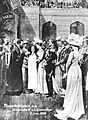 Doopplechtigheid van prinses Juliana in de Willemskerk te Den Haag, SFA222009380.jpg 1,700 × 2,318; 915 KB
-
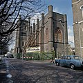
 Exterieur - 's-Gravenhage - 20085397 - RCE.jpg 807 × 1,200; 259 KB
-
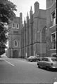
 Exterieur voorgevel - 's-Gravenhage - 20085398 - RCE.jpg 960 × 1,200; 302 KB
-

-
 Gezicht op de Willemskerk in Den Haag, RP-F-F12050.jpg 4,516 × 2,148; 1.13 MB
-
 Interieur - 's-Gravenhage - 20085391 - RCE.jpg 1,200 × 962; 226 KB
-
 Interieur - 's-Gravenhage - 20085392 - RCE.jpg 1,200 × 970; 218 KB
-
 Interieur - 's-Gravenhage - 20085393 - RCE.jpg 1,200 × 962; 213 KB
-
 Interieur - 's-Gravenhage - 20085399 - RCE.jpg 1,200 × 962; 246 KB
-
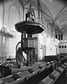
 Interieur met orgel - 's-Gravenhage - 20085394 - RCE.jpg 974 × 1,200; 211 KB
-
 Interieur met preekstoel - 's-Gravenhage - 20085395 - RCE.jpg 960 × 1,200; 216 KB
-
 Kapspanten - 's-Gravenhage - 20085401 - RCE.jpg 1,191 × 1,200; 266 KB
-
 Linker zijgevel - 's-Gravenhage - 20085405 - RCE.jpg 955 × 1,200; 319 KB
-
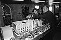
 Miniatuur kapkonstruktie - 's-Gravenhage - 20085400 - RCE.jpg 1,200 × 954; 124 KB
-
 Nassaulaan 1-12, The Hague, Netherlands - panoramio (11).jpg 2,048 × 1,148; 511 KB
-
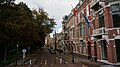
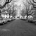
 Nassaulaan, overzicht - 's-Gravenhage - 20085396 - RCE.jpg 809 × 1,200; 179 KB
-

-

-

-
-
 Plafond koninklijke loge - 's-Gravenhage - 20085419 - RCE.jpg 1,191 × 1,200; 206 KB
-
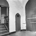
 Portaal zijgevel - 's-Gravenhage - 20085416 - RCE.jpg 1,188 × 1,200; 210 KB
-
-
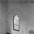 Raam in toren interieur - 's-Gravenhage - 20085415 - RCE.jpg 1,186 × 1,200; 161 KB
-
 Rechter zijgevel - 's-Gravenhage - 20085407 - RCE.jpg 960 × 1,200; 288 KB
-
 Rechter zijgevel - 's-Gravenhage - 20085422 - RCE.jpg 959 × 1,200; 256 KB
-
 Toren bekroning - 's-Gravenhage - 20085411 - RCE.jpg 1,200 × 1,194; 298 KB
-
 Toren bekroning - 's-Gravenhage - 20085412 - RCE.jpg 1,193 × 1,200; 285 KB
-
 Torenportaal - 's-Gravenhage - 20085417 - RCE.jpg 1,200 × 1,200; 210 KB
-
 Torenportaal met opgang naar koninklijke loge - 's-Gravenhage - 20085418 - RCE.jpg 1,195 × 1,200; 186 KB
-
 Voorgevel - 's-Gravenhage - 20085420 - RCE.jpg 1,192 × 1,200; 410 KB
-
 Voorgevel - 's-Gravenhage - 20085421 - RCE.jpg 950 × 1,200; 239 KB
-
 Voorgevel linkerhelft - 's-Gravenhage - 20085403 - RCE.jpg 958 × 1,200; 309 KB
-
 Voorgevel linkerzijde - 's-Gravenhage - 20085406 - RCE.jpg 1,200 × 951; 309 KB
-
 Wijzerplaat op toren - 's-Gravenhage - 20085413 - RCE.jpg 1,200 × 1,195; 457 KB
-
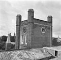
 WLM - roel1943 - Voormalige Koninklijke Manege van Koning Willem II..jpg 1,020 × 1,279; 425 KB


.jpg)


_Vues_de_Hollande_(serietitel_op_object),_RP-F-F12178.jpg)


.jpg)


