Category:Willibrordskerk Borger
| Object location | | View all coordinates using: OpenStreetMap |
|---|
church in Borger, Netherlands  | |||||
| Upload media | |||||
| Instance of | |||||
|---|---|---|---|---|---|
| Location | Borger, Borger-Odoorn, Drenthe, Netherlands | ||||
| Has part(s) |
| ||||
| Heritage designation | |||||
| Inception |
| ||||
 | |||||
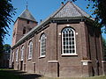
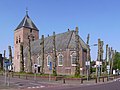
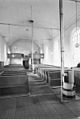
English: The Willibrordskerk or Dorpskerk (village church) in Borger
Kerk:
|
This is a category about rijksmonument number 9897
|
Toren:
|
This is a category about rijksmonument number 9898
|
| Address |
|
Media in category "Willibrordskerk Borger"
The following 10 files are in this category, out of 10 total.
-
 Borger 131.JPG 3,264 × 2,448; 2.17 MB
-
 Borger, kerk foto3 2009-04-25 11.37.JPG 3,072 × 2,304; 5.22 MB
-
 Borger-VC.jpg 1,280 × 960; 428 KB
-
 Dorpskerk van Borger.jpg 972 × 1,296; 278 KB
-
 Exterieur noordgevel - Borger - 20038115 - RCE.jpg 804 × 1,200; 241 KB
-
 Exterieur zuid-westgevel - Borger - 20038116 - RCE.jpg 804 × 1,200; 245 KB
-
 Interieur naar het oosten - Borger - 20038117 - RCE.jpg 1,200 × 804; 125 KB
-
 Interieur naar het westen - Borger - 20038118 - RCE.jpg 804 × 1,200; 162 KB
-
 Interieur, aanzicht orgel, orgelnummer 204 - Borger - 20370568 - RCE.jpg 768 × 1,200; 147 KB
-
 Kerktoren Willibrordkerk Borger.jpg 876 × 1,296; 207 KB


