Category:Windmills in County Down
Media in category "Windmills in County Down"
The following 18 files are in this category, out of 18 total.
-
 Old Windmill behind School Road (geograph 2627346).jpg 1,024 × 658; 60 KB
-
 Old windmill near Cloughey - geograph.org.uk - 295439.jpg 640 × 426; 113 KB
-
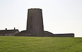
 Old windmill near Kearney - geograph.org.uk - 751049.jpg 640 × 480; 60 KB
-
 Old windmill, Holywood - geograph.org.uk - 841420.jpg 480 × 640; 459 KB
-
 Old windmill, Portaferry (1) - geograph.org.uk - 620385.jpg 640 × 480; 45 KB
-
 Old windmill, Portaferry (2) - geograph.org.uk - 620394.jpg 640 × 480; 86 KB
-
 Old windmill, Portaferry - geograph.org.uk - 591389.jpg 640 × 427; 66 KB
-
 Portaferry (02), August 2009.JPG 4,272 × 2,848; 3.41 MB
-
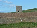
 Saintfield Windmill.jpg 2,304 × 3,456; 2.56 MB
-
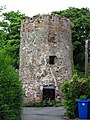
 The old mill, Holywood - geograph.org.uk - 218460.jpg 480 × 640; 73 KB
-
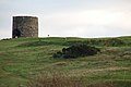
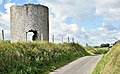
 The Old Windmill, Knockinelder - geograph.org.uk - 3808.jpg 640 × 480; 57 KB
-
 Warrenpoint Windmill.jpg 800 × 801; 171 KB
-
 Whitespots Country Park, Newtownards (1) - geograph.org.uk - 256280.jpg 640 × 426; 153 KB
-
 Windmill - geograph.org.uk - 66718.jpg 640 × 480; 94 KB
-
 Windmill near Kearney - geograph.org.uk - 562964.jpg 629 × 324; 53 KB
-
 Windmill stump, Ballywalter (August 2017) (geograph 5502939).jpg 640 × 393; 88 KB
-
 Windmill stump, Crawfordsburn - geograph.org.uk - 524211.jpg 640 × 426; 92 KB
-
 The Ardview Road near Killinchy - geograph.org.uk - 292444.jpg 640 × 426; 128 KB
.jpg)


_-_geograph.org.uk_-_620385.jpg)
_-_geograph.org.uk_-_620394.jpg)

,_August_2009.JPG)


_-_geograph.org.uk_-_256280.jpg)


_(geograph_5502939).jpg)

