Category:Wipfelsfurt
| Object location | | View all coordinates using: OpenStreetMap |
|---|
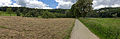
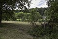
Deutsch: Die Wipfelsfurt ist ein von der Donau durchflossenes kesselförmiges Tal und liegt im Naturschutzgebiet Weltenburger Enge inmitten des Donaudurchbruchs zwischen Kloster Weltenburg und Kelheim.
valley  | |||||
| Upload media | |||||
| Instance of | |||||
|---|---|---|---|---|---|
| Location |
| ||||
 | |||||
Media in category "Wipfelsfurt"
The following 5 files are in this category, out of 5 total.
-
 2013 Weltenburg 02.jpg 15,213 × 4,981; 14.46 MB
-
 2013 Weltenburg 15.jpg 5,184 × 3,456; 3.49 MB
-
 Metoriteneinschlagkrater Wipfelsfurt Kelheim Niederbayern.JPG 2,039 × 1,395; 1.81 MB
-
 Wipfelsfurt Weltenburger Enge.jpg 5,184 × 3,456; 7.06 MB
-
 Wipfelsfurt.jpg 1,600 × 1,200; 1.24 MB


