Category:Withlacoochee State Trail in Citrus County, Florida
Media in category "Withlacoochee State Trail in Citrus County, Florida"
The following 79 files are in this category, out of 79 total.
-
 1967 Ford F-100 Bright Teal Pickup.jpg 5,152 × 3,864; 7.82 MB
-
 Burger Station sign from WST.JPG 5,152 × 3,864; 8.22 MB
-
 Citrus Springs Trailhead Entrance(WST).JPG 4,000 × 3,000; 2.5 MB
-
 DeSoto Trail sign on WST; Inverness.jpg 5,152 × 3,864; 8.04 MB
-
 FL 44 Westbound WST Ramp.JPG 4,000 × 3,000; 2.45 MB
-
 Ford 841 Powermaster north of Inverness, FLA.JPG 5,152 × 3,864; 7.28 MB
-
 Former ACL Telegraph Poles on WST.JPG 5,152 × 3,864; 7.09 MB
-
 Great Blue Heron - panoramio (7).jpg 2,001 × 1,324; 1.14 MB
-
 Great Blue Heron - panoramio (8).jpg 1,634 × 1,182; 741 KB
-
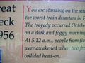
 Great Pineola Train Wreck of 1956-1.JPG 4,000 × 3,000; 1.75 MB
-
 Great Pineola Train Wreck of 1956-2.JPG 4,000 × 3,000; 2.37 MB
-
 Great Pineola Train Wreck of 1956-3.JPG 4,000 × 3,000; 2.32 MB
-
 Great Pineola Train Wreck of 1956-4.JPG 4,000 × 3,000; 2.32 MB
-
 Great Pineola Train Wreck of 1956-5.JPG 4,000 × 3,000; 2.46 MB
-
 Great Pineola Train Wreck of 1956-6.JPG 4,000 × 3,000; 2.37 MB
-
 Great Pineola Train Wreck of 1956-7.JPG 4,000 × 3,000; 2.38 MB
-
 Gulf Junction Trailhead WST Bathrooms.JPG 4,000 × 3,000; 2.22 MB
-
 Gulf Junction Trailhead WST Picnic Shelter.JPG 4,000 × 3,000; 2.22 MB
-
 Inverness ACL Depot-2-.jpg 1,091 × 737; 119 KB
-
 Inverness FL Withla State Trl caboose01.jpg 4,288 × 3,216; 2.01 MB
-
 Inverness FL Withla State Trl east01.jpg 4,288 × 3,216; 1.84 MB
-
 Inverness FL Withla State Trl west01.jpg 4,288 × 3,216; 2.05 MB
-
 Inverness Florida Banner.jpg 4,000 × 571; 580 KB
-
 Inverness Trailhead; WST Bathrooms.jpg 4,000 × 3,000; 2.38 MB
-
 North Entrance; WST Gulf Jct Trailhead.JPG 4,000 × 3,000; 2.68 MB
-
 Northbound Withlacoochee State Trail-FL 44 Bridge.JPG 637 × 430; 68 KB
-
 Old House - panoramio (27).jpg 3,898 × 2,700; 3.66 MB
-
 Pineola Train Wreck sign.jpg 2,448 × 3,264; 1.22 MB
-
 Road signs along WST in Inverness, FLA.jpg 5,152 × 3,864; 6.9 MB
-
 SB Apopka Avenue @ WST Blinker-1.JPG 4,000 × 3,000; 2.28 MB
-
 SB Apopka Avenue @ WST Blinker-2.JPG 4,000 × 3,000; 2.19 MB
-
 SB US 41 from Withlacoochee State Trail.JPG 4,000 × 3,000; 2.17 MB
-
 SE Withlacoochee St Trl @ Apopka Ave Blinker.JPG 4,000 × 3,000; 2.58 MB
-
 South Entrance; WST Gulf Jct Trailhead.JPG 4,000 × 3,000; 2.04 MB
-
 South WST from Citrus Springs Ramp.JPG 4,000 × 3,000; 2.69 MB
-
 Southbound Withlacoochee State Trail-FL 44 Bridge.JPG 637 × 430; 78 KB
-
 St Raphael @ North Highland Estates; Citrus CoFL.JPG 5,152 × 3,864; 8.09 MB
-
 US 41 Independence Hwy Signal-1.jpg 5,152 × 3,864; 7.97 MB
-
 US 41 Independence Hwy Signal-2.jpg 5,152 × 3,864; 8 MB
-
 US 41 Independence Hwy Signal-3.jpg 5,152 × 3,864; 8.07 MB
-
 WB FL 44 over the Withlacoochee State Trail.jpg 5,152 × 3,864; 8.07 MB
-
 Withlacoochee State Trail & Old Inverness-Brooksville Line.jpg 1,800 × 1,215; 1.68 MB
-
 Withlacoochee State Trail sign01.jpg 2,448 × 3,264; 2.07 MB
-
 Withlacoochee State Trail under US 41.jpg 1,080 × 729; 195 KB
-
 Withlacoochee State Trail(R-797).jpg 1,818 × 1,228; 1.02 MB
-
 Withlacoochee State Trail(R-800).JPG 455 × 307; 62 KB
-
 Withlacoochee State Trail; First Birdhouse.JPG 4,000 × 3,000; 2.6 MB
-
 WST - South Citrus Springs Sign.JPG 4,000 × 3,000; 2.44 MB
-
 WST Birdhouse.jpg 1,800 × 1,215; 1.47 MB
-
 WST Bridge over Henderson Lake.JPG 4,000 × 3,000; 2.83 MB
-
 WST Citrus CR 486 Crosswalk; North Side.jpg 4,000 × 3,000; 2.25 MB
-
 WST Citrus CR 486 Crosswalk; South Side.jpg 4,000 × 3,000; 2.81 MB
-
 WST Citrus Springs Trailhead Garbage Pail.JPG 4,000 × 3,000; 2.32 MB
-
 WST Citrus Springs Trailhead Ramp.JPG 4,000 × 3,000; 2.41 MB
-
 WST Citrus Springs Trailhead Sign(Close-Up).JPG 4,000 × 3,000; 2.23 MB
-
 WST Faded Mile Marker; Hernando, FLA.JPG 5,152 × 3,864; 7.4 MB
-
 WST Floral City Heritage Days(December 2009).jpg 1,800 × 1,215; 1.06 MB
-
 WST Fort Cooper Entrance.JPG 4,000 × 3,000; 2.49 MB
-
 WST Fort Cooper Historic Sign.JPG 4,000 × 3,000; 2.02 MB
-
 WST Great Train Wreck of 1956(Pineola, Florida).jpg 1,800 × 1,215; 1.65 MB
-
 WST Gulf Junction Trailhead - Sign and Maps.JPG 4,000 × 3,000; 2.56 MB
-
 WST Hernando Trailhead Park.JPG 4,000 × 3,000; 2.46 MB
-
 WST Hernando Trailhead sign.JPG 4,000 × 3,000; 2.11 MB
-
 WST Holder Trail Head (DSCN3782).JPG 5,152 × 3,864; 7.36 MB
-
 WST Holder Trail Head (DSCN3783).JPG 5,152 × 3,864; 8.31 MB
-
 WST Holder Trail Head (DSCN3784).JPG 5,152 × 3,864; 8 MB
-
 WST Holder Trail Head (DSCN3785).JPG 5,152 × 3,864; 6.77 MB
-
 WST Holder Trail Head (DSCN3786).JPG 5,152 × 3,864; 8.21 MB
-
 WST Inverness Trailhead; Caboose & Bell.jpg 4,000 × 3,000; 2.34 MB
-
 WST Inverness Trailhead; Citrus Springs to Trilby.jpg 4,000 × 3,000; 2.38 MB
-
 WST Inverness Trailhead; Picnic Shelter.jpg 4,000 × 3,000; 2.39 MB
-
 WST Northbound Fort Cooper signs.JPG 4,000 × 3,000; 2.22 MB
-
 WST South Detour @ CCR 486.JPG 4,000 × 3,000; 2.78 MB
-
 WST South Inverness Picnic Area.JPG 4,000 × 3,000; 2.45 MB
-
 WST Southbound Fort Cooper signs.JPG 4,000 × 3,000; 2.45 MB
-
 WST Water Fountain, Shelter, and Whistle Marker.jpg 1,800 × 1,215; 1.38 MB
-
 WST Whispering Pines Park FT Marker.JPG 4,000 × 3,000; 2.8 MB
-
 WST Whispering Pines Park Sign North.JPG 4,000 × 3,000; 2.17 MB
-
 WST Whispering Pines Park Sign South.JPG 4,000 × 3,000; 2.58 MB


.JPG)


.jpg)
.jpg)


.jpg)


.jpg)
.JPG)


.JPG)

.jpg)


.jpg)


.JPG)
.JPG)
.JPG)
.JPG)
.JPG)


