Category:Yashimagahara Wetland
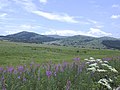
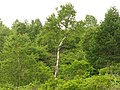
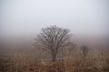
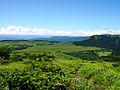
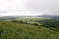
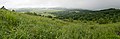
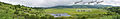
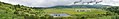
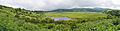
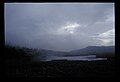
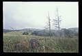
English: Yashimagahara Wetland is a wetland in northwestern Kirigamine, on the border of the city of Suwa and the town of Shimosuwa in Nagano prefecture, Japan. It has an area of 43.2 hectares at a height of 1,632 metres above sea level.
| Object location | | View all coordinates using: OpenStreetMap |
|---|
| Upload media | |||||
| Instance of | |||||
|---|---|---|---|---|---|
| Location | |||||
 | |||||
Media in category "Yashimagahara Wetland"
The following 48 files are in this category, out of 48 total.
-
 Kamaga-ike Yashimagahara Wetland01s3.jpg 4,592 × 3,056; 9.16 MB
-
 Kamagaike, Yashimagahara Wetland -October 2011 a.jpg 1,600 × 950; 1.29 MB
-
 Kiri-mine.jpg 640 × 480; 92 KB
-
 Pcs34560 sirakaba01.JPG 3,264 × 2,448; 4.65 MB
-
 Pcs34560 sirakaba02.JPG 3,264 × 2,448; 3.79 MB
-
 Shimosuwa, Suwa District, Nagano Prefecture 393-0000, Japan - panoramio (1).jpg 2,560 × 1,717; 1.39 MB
-
 Shimosuwa, Suwa District, Nagano Prefecture 393-0000, Japan - panoramio (2).jpg 2,560 × 1,717; 1.46 MB
-
 Shimosuwa, Suwa District, Nagano Prefecture 393-0000, Japan - panoramio (6).jpg 1,926 × 2,560; 1.87 MB
-
 Shimosuwa, Suwa District, Nagano Prefecture 393-0000, Japan - panoramio (7).jpg 2,560 × 1,926; 1.91 MB
-
 Shimosuwa, Suwa District, Nagano Prefecture 393-0000, Japan - panoramio.jpg 2,560 × 1,717; 1.48 MB
-
 Swamp - panoramio.jpg 816 × 612; 346 KB
-
 USER2184.jpg 4,608 × 3,456; 4.35 MB
-
 Yashima01.JPG 3,648 × 2,736; 3.75 MB
-
 Yashima02.JPG 3,648 × 2,736; 4.34 MB
-
 Yashima03.JPG 3,648 × 2,736; 3.59 MB
-
 Yashima04.JPG 3,648 × 2,736; 4.36 MB
-
 Yashima05.JPG 3,648 × 2,736; 4.14 MB
-
 Yashima06.JPG 3,648 × 2,736; 5.7 MB
-
 Yashima07.JPG 3,648 × 2,736; 3.59 MB
-
 Yashima08.JPG 3,648 × 2,736; 3.67 MB
-
 Yashimaga-ike Yashimagahara Wetland01s3.jpg 4,592 × 3,056; 9.78 MB
-
 Yashimagahara Wetland 01.jpg 3,838 × 2,558; 2.93 MB
-
 Yashimagahara Wetland 02.jpg 3,872 × 2,581; 2.5 MB
-
 Yashimagahara Wetland 03.jpg 3,888 × 2,592; 4.26 MB
-
 Yashimagahara Wetland 04.jpg 3,888 × 2,592; 1.88 MB
-
 Yashimagahara Wetland 05.jpg 3,888 × 2,592; 1.93 MB
-
 Yashimagahara Wetland 06.jpg 3,888 × 2,592; 1.92 MB
-
 Yashimagahara Wetland 07.jpg 3,842 × 2,562; 2.39 MB
-
 Yashimagahara Wetland 08.jpg 3,888 × 2,592; 3.97 MB
-
 Yashimagahara Wetland 09.jpg 3,812 × 2,542; 2.4 MB
-
 Yashimagahara Wetland 10.jpg 6,145 × 2,018; 4.3 MB
-
 Yashimagahara Wetland 11-2.jpg 6,746 × 1,093; 1.81 MB
-
 Yashimagahara Wetland 11-3.jpg 6,746 × 1,093; 1.87 MB
-
 Yashimagahara Wetland 11-4.jpg 1,547 × 247; 142 KB
-
 Yashimagahara Wetland 11.jpg 5,751 × 1,494; 2.24 MB
-
 Yashimagahara Wetland01s3.jpg 4,592 × 3,056; 10.16 MB
-
 Yashimagahara Wetland02s3.jpg 4,592 × 3,056; 10.56 MB
-
 Yashimagahara-Shitsugen Wetland Aerial Photograph.jpg 2,456 × 1,845; 1.43 MB
-
 Yashimagaike, -August 2010 a.jpg 1,024 × 768; 212 KB
-
 ノアザミの花冠部のアップ。八島が原湿原で撮影 Pcs34560 IMG4198.jpg 2,352 × 1,568; 1.1 MB
-
 ビーナスライン 八島ヶ原湿原 20130709 - panoramio.jpg 2,736 × 1,824; 2.36 MB
-
 八島湿原1 - panoramio.jpg 2,816 × 2,112; 2.93 MB
-
 八島湿原2 - panoramio.jpg 2,816 × 2,112; 2.83 MB
-
 八島湿原の状況 Pcs34560 00114.jpg 5,782 × 3,946; 2.88 MB
-
 八島湿原の状況 Pcs34560 00118.jpg 5,782 × 3,946; 808 KB
-
 八島湿原の状況 Pcs34560 00124.jpg 5,782 × 3,946; 1.97 MB
-
 八島湿原の状況 Pcs34560 00142.jpg 5,782 × 3,946; 1.6 MB
-
 八島湿原の状況 Pcs34560 00149.jpg 5,782 × 3,946; 1.85 MB


.jpg)
.jpg)
.jpg)
.jpg)