Category:Ziegelhütte, Cham
| Object location | | View all coordinates using: OpenStreetMap |
|---|
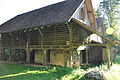
brickyard building in Hagendorn in the municipality of Cham in the canton of Zug, Switzerland  | |||||
| Upload media | |||||
| Instance of | |||||
|---|---|---|---|---|---|
| Part of | |||||
| Location |
| ||||
| Street address |
| ||||
| Occupant |
| ||||
| Heritage designation | |||||
 | |||||
Media in category "Ziegelhütte, Cham"
The following 9 files are in this category, out of 9 total.
-
 Cham Ziegelhütte 1.jpg 4,288 × 2,848; 4.77 MB
-
 Cham Ziegelhütte 2.jpg 4,288 × 2,848; 6.34 MB
-
 Cham Ziegelhütte 3.jpg 4,288 × 2,848; 6.18 MB
-
 Cham Ziegelhütte 4.jpg 2,848 × 4,288; 5 MB
-
 Cham Ziegelhütte 5.jpg 4,288 × 2,848; 6.14 MB
-
 Cham Ziegelhütte 6.jpg 4,288 × 2,848; 6.18 MB
-
 Cham Ziegelhütte 7.jpg 4,288 × 2,848; 6.3 MB
-
 Cham Ziegelhütte 8.jpg 4,288 × 2,848; 5.33 MB
-
 Cham Ziegelhütte 9.jpg 4,288 × 2,848; 6.32 MB


