| Name
|
Heritage list
|
Place
|
Street address
|
Coordinates
|
place_id
|
Image
|
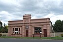
| Brunswick West Tramway Substation (Q96741862)
|
listed on the Victorian Heritage Register
|
|
|
37°46′09″S 144°56′35″E / 37.76916°S 144.94306°E / -37.76916; 144.94306
|
201776
|
|
| Bruntons Bridge (Q33183936)
|
listed on the Victorian Heritage Register
|
Walhalla
|
|
|
1177
|
|
| Buchan Caves (Q4982534)
|
listed on the Victorian Heritage Register
|
Buchan Caves Reserve
|
|
37°29′45″S 148°09′47″E / 37.4958°S 148.1631°E / -37.4958; 148.1631
|
71610 11578
71610
|

|
| Buckeye Creek Railway Bridge Complex (Q66768315)
|
listed on the Victorian Heritage Register
|
Ravenswood
|
|
36°52′07″S 144°13′48″E / 36.8686°S 144.23°E / -36.8686; 144.23
|
12860
|
|
| Buckland River Crossing (Q116859464)
|
listed on the Victorian Heritage Register
|
Buckland
|
|
36°47′38″S 146°50′53″E / 36.794°S 146.848°E / -36.794; 146.848
|
208911
|
|
| Buckland River Hydraulic Gold Sluicing Paddock (Q66766054)
|
listed on the Victorian Heritage Register
|
Buckland
|
|
36°50′27″S 146°50′35″E / 36.8409°S 146.843°E / -36.8409; 146.843
|
5077
|
|
| Bucyrus Railroad Steam Shovel (Q66767487)
|
listed on the Victorian Heritage Register
|
Lake Goldsmith
|
|
37°33′13″S 143°22′59″E / 37.5536°S 143.383°E / -37.5536; 143.383
|
11125
|
|
| Buda (Q58280651)
|
listed on the Victorian Heritage Register
|
Castlemaine
|
|
37°03′30″S 144°13′25″E / 37.058333333333°S 144.22369444444°E / -37.058333333333; 144.22369444444
|
274
|
|
| Bull and Mouth Hotel (Q55670348)
|
listed on the Victorian Heritage Register
|
|
|
37°02′48″S 143°44′15″E / 37.046777777778°S 143.73755555556°E / -37.046777777778; 143.73755555556
|
13473
|

|
| Bundoora Park Homestead (Q66766064)
|
listed on the Victorian Heritage Register
|
Bundoora
|
|
37°42′18″S 145°03′04″E / 37.7049°S 145.051°E / -37.7049; 145.051
|
4678
|
|
| Bundoora Primary School No.1915 (Q66766066)
|
listed on the Victorian Heritage Register
|
Bundoora
|
|
37°41′09″S 145°04′08″E / 37.6858°S 145.069°E / -37.6858; 145.069
|
5205
|
|
| Buninyong Public Library (Q55768522)
|
listed on the Victorian Heritage Register
|
Buninyong
|
|
37°38′55″S 143°53′03″E / 37.648638888889°S 143.88416666667°E / -37.648638888889; 143.88416666667
|
183
|
|
| Buninyong Town Hall (Q4997703)
|
listed on the Victorian Heritage Register
|
Buninyong
|
|
37°39′03″S 143°53′06″E / 37.6508°S 143.885°E / -37.6508; 143.885
|
182
|
|
| Buninyong botanic gardens (Q5926807)
|
listed on the Victorian Heritage Register
|
Buninyong
|
|
37°39′00″S 143°53′02″E / 37.65°S 143.884°E / -37.65; 143.884
|
1720
|

|
| Bunyip Railway Substation (Q56701513)
|
listed on the Victorian Heritage Register
|
Bunyip
|
|
38°05′55″S 145°42′45″E / 38.098555555556°S 145.71261111111°E / -38.098555555556; 145.71261111111
|
12820
|

|
| Burchet Creek Bridge (Q66766137)
|
listed on the Victorian Heritage Register
|
Caramut
|
|
37°58′09″S 142°32′24″E / 37.9691°S 142.54°E / -37.9691; 142.54
|
5991
|
|
| Burger Cottages (Q66768223)
|
listed on the Victorian Heritage Register
|
Penshurst
|
|
37°51′59″S 142°14′53″E / 37.8665°S 142.248°E / -37.8665; 142.248
|
12960
|
|
| Burke & Wills Memorial Obelisk (Q39893696)
|
listed on the Victorian Heritage Register
|
Castlemaine
|
|
37°04′00″S 144°13′34″E / 37.06667°S 144.22614°E / -37.06667; 144.22614
|
5643
|
|
| Burlington Terrace (Q66766537)
|
listed on the Victorian Heritage Register
|
East Melbourne
|
|
37°48′33″S 144°58′41″E / 37.8093°S 144.978°E / -37.8093; 144.978
|
380
|
|
| Burnley Gardens (Q5926268)
|
listed on the Victorian Heritage Register
|
Burnley
|
|
37°49′45″S 145°01′20″E / 37.82925°S 145.02216666667°E / -37.82925; 145.02216666667
|
1892
|

|
| Burns House 'Kangaroo' (Q66765792)
|
listed on the Victorian Heritage Register
|
Bend of Islands
|
|
37°41′58″S 145°17′02″E / 37.6995°S 145.284°E / -37.6995; 145.284
|
14221
|
|
| Burswood (Q66768267)
|
listed on the Victorian Heritage Register
|
Portland
|
|
38°21′31″S 141°36′25″E / 38.3586°S 141.607°E / -38.3586; 141.607
|
938
|
|
| Byramine Homestead (Q66766071)
|
listed on the Victorian Heritage Register
|
Burramine
|
|
35°59′25″S 145°51′32″E / 35.9902°S 145.859°E / -35.9902; 145.859
|
1258
|
|
| CBC Bank building (Q56737731)
|
listed on the Victorian Heritage Register
|
Castlemaine
|
|
37°03′58″S 144°12′59″E / 37.066083333333°S 144.21641666667°E / -37.066083333333; 144.21641666667
|
251
|

|
| CFA Training College (Q5010437)
|
listed on the Victorian Heritage Register
|
Fiskville
|
|
37°40′56″S 144°13′37″E / 37.6822°S 144.227°E / -37.6822; 144.227
|
44704
|

|
| CSIRAC (Q2590905)
|
listed on the Victorian Heritage Register
|
|
|
37°48′13″S 144°58′18″E / 37.80369°S 144.97162°E / -37.80369; 144.97162
|
114928
|

|
| Cab Building and House (Q66767642)
|
listed on the Victorian Heritage Register
|
Maryborough
|
|
37°02′42″S 143°44′20″E / 37.0451°S 143.739°E / -37.0451; 143.739
|
12955
|
|
| Cable Tram Engine House (Q56754355)
|
listed on the Victorian Heritage Register
|
Fitzroy
|
|
37°48′20″S 144°58′26″E / 37.805583333333°S 144.974°E / -37.805583333333; 144.974
|
456
|
|
| Cairo Flats (Q48815840)
|
listed on the Victorian Heritage Register
|
Fitzroy
|
|
37°48′11″S 144°58′29″E / 37.803°S 144.9746°E / -37.803; 144.9746
|
2093
|

|
| Calder Woodburn Memorial Avenue (Q56867890)
|
listed on the Victorian Heritage Register
|
Goulburn Valley Highway
Goulburn Valley Freeway
|
|
36°34′26″S 145°20′33″E / 36.573805555556°S 145.34258333333°E / -36.573805555556; 145.34258333333
|
5167
|

|
| Caledonian Inn (Q56257005)
|
listed on the Victorian Heritage Register
|
Port Fairy
|
|
38°23′00″S 142°14′02″E / 38.383388888889°S 142.23394444444°E / -38.383388888889; 142.23394444444
|
2607
|

|
| Calembeen Park (Q66766405)
|
listed on the Victorian Heritage Register
|
Creswick
|
|
37°25′03″S 143°53′20″E / 37.4174°S 143.889°E / -37.4174; 143.889
|
14382
|
|
| California Gully Primary School (Q66766079)
|
listed on the Victorian Heritage Register
|
California Gully
|
|
36°43′59″S 144°15′00″E / 36.733°S 144.25°E / -36.733; 144.25
|
2483
|
|
| Callanan's Chemist (Q66768601)
|
listed on the Victorian Heritage Register
|
Werribee
|
|
37°54′03″S 144°39′47″E / 37.9009°S 144.663°E / -37.9009; 144.663
|
11577
|
|
| Camberwell Court House and Police Station (Q66766083)
|
listed on the Victorian Heritage Register
|
Camberwell
|
|
37°49′59″S 145°03′32″E / 37.8331°S 145.059°E / -37.8331; 145.059
|
1681
|
|
| Camberwell Tram Substation (Q66766085)
|
listed on the Victorian Heritage Register
|
Camberwell
|
|
37°49′50″S 145°03′29″E / 37.8305°S 145.058°E / -37.8305; 145.058
|
192286
|
|
| Cambourne (Q66768643)
|
listed on the Victorian Heritage Register
|
Wodonga
|
|
36°06′38″S 146°53′42″E / 36.1105°S 146.895°E / -36.1105; 146.895
|
4062
|
|
| Cambridge Terrace (Q66766182)
|
listed on the Victorian Heritage Register
|
Carlton North
|
|
37°47′31″S 144°58′12″E / 37.7919°S 144.97°E / -37.7919; 144.97
|
217
|
|
| Cameron Hill (Q66768104)
|
listed on the Victorian Heritage Register
|
Murgheboluc
|
|
38°05′48″S 144°08′13″E / 38.0967°S 144.137°E / -38.0967; 144.137
|
864
|
|
| Camerons Saw Mill (Q66765670)
|
listed on the Victorian Heritage Register
|
Bailieston
|
|
36°42′10″S 145°05′17″E / 36.7029°S 145.088°E / -36.7029; 145.088
|
12629
|
|
| Camp Eureka (Q66768670)
|
listed on the Victorian Heritage Register
|
Yarra Junction
|
|
37°47′27″S 145°38′20″E / 37.7909°S 145.639°E / -37.7909; 145.639
|
6060
|
|
| Camp Hill Central School No.1976 (Q66765805)
|
listed on the Victorian Heritage Register
|
Bendigo
Bendigo
|
|
36°45′22″S 144°16′44″E / 36.7562°S 144.279°E / -36.7562; 144.279
|
138
|
|
| Campaspe Park (Q66767177)
|
listed on the Victorian Heritage Register
|
Goornong
|
|
36°36′17″S 144°34′34″E / 36.6047°S 144.576°E / -36.6047; 144.576
|
3309
|
|
| Camperdown Steam Laundry (Q66766104)
|
listed on the Victorian Heritage Register
|
Camperdown
|
|
38°13′47″S 143°08′53″E / 38.2298°S 143.148°E / -38.2298; 143.148
|
5310
|
|
| Camperdown Turf Club Grandstand (Q66766106)
|
listed on the Victorian Heritage Register
|
Camperdown
|
|
38°13′00″S 143°09′04″E / 38.2168°S 143.151°E / -38.2168; 143.151
|
13982
|
|
| Camperdown botanic gardens (Q5926811)
|
listed on the Victorian Heritage Register
|
Camperdown
|
|
38°14′13″S 143°07′04″E / 38.23695°S 143.11773°E / -38.23695; 143.11773
|
4374
|
|
| Canterbury Mansions (Q66766116)
|
listed on the Victorian Heritage Register
|
Canterbury
|
|
37°49′29″S 145°04′59″E / 37.8246°S 145.083°E / -37.8246; 145.083
|
197
|
|
| Canterbury Terrace (Q66766540)
|
listed on the Victorian Heritage Register
|
East Melbourne
|
|
37°48′49″S 144°59′10″E / 37.8136°S 144.986°E / -37.8136; 144.986
|
395
|
|
| Cape Nelson Lighthouse (Q28375133)
|
listed on the Victorian Heritage Register
|
Portland West
|
|
38°25′52″S 141°32′32″E / 38.43108°S 141.5423°E / -38.43108; 141.5423
|
6668
112734
68063 4950
6668
112734
68063
|

|
| Cape Otway Lighthouse (Q5034981)
|
listed on the Victorian Heritage Register
|
Great Otway National Park
|
|
38°51′26″S 143°30′42″E / 38.85722222°S 143.51166667°E / -38.85722222; 143.51166667
38°51′26″S 143°30′44″E / 38.857087°S 143.512087°E / -38.857087; 143.512087
|
1914
|

|
| Cape Schanck Lighthouse (Q5035039)
|
listed on the Victorian Heritage Register
|
Cape Schanck
|
|
38°29′34″S 144°53′11″E / 38.492811°S 144.886458°E / -38.492811; 144.886458
|
4443
|

|
| Capital Theatre (Q47000700)
|
listed on the Victorian Heritage Register
|
|
|
36°45′26″S 144°16′35″E / 36.75722°S 144.276361°E / -36.75722; 144.276361
|
145
|
|
| Capitol Theatre (Q5035939)
|
listed on the Victorian Heritage Register
|
Melbourne central business district
|
|
37°48′55″S 144°57′58″E / 37.8154°S 144.966°E / -37.8154; 144.966
|
818
|

|
| Captain John Mills House (Q66768238)
|
listed on the Victorian Heritage Register
|
Port Fairy
|
|
38°23′11″S 142°14′20″E / 38.3865°S 142.239°E / -38.3865; 142.239
|
2678
|
|
| Cargo Sheds 4, 5, 6, 7, 8, 9 (Q66768405)
|
listed on the Victorian Heritage Register
|
South Wharf
|
|
37°49′27″S 144°57′00″E / 37.8241°S 144.95°E / -37.8241; 144.95
|
2339
|

|
| Caringal Flats (Q66768525)
|
listed on the Victorian Heritage Register
|
Toorak
|
|
37°50′18″S 145°01′05″E / 37.8382°S 145.018°E / -37.8382; 145.018
|
1168
|
|
| Carinya (Q56057153)
|
listed on the Victorian Heritage Register
|
Tarrawingee
|
|
36°23′23″S 146°27′02″E / 36.389805555556°S 146.45041666667°E / -36.389805555556; 146.45041666667
|
1149
|

|
| Carlsruhe railway station (Q5042923)
|
listed on the Victorian Heritage Register
|
|
|
37°18′25″S 144°29′03″E / 37.3069°S 144.4842°E / -37.3069; 144.4842
|
68826 206
68826
|
|
| Carlton Club building (Q56736337)
|
listed on the Victorian Heritage Register
|
Carlton
|
|
37°47′54″S 144°58′07″E / 37.798416666667°S 144.96861111111°E / -37.798416666667; 144.96861111111
|
213
|

|
| Carlton Court House (Q56736571)
|
listed on the Victorian Heritage Register
|
Carlton
|
|
37°47′52″S 144°58′07″E / 37.797694444444°S 144.96869444444°E / -37.797694444444; 144.96869444444
|
216
|
|
| Carlton Gardens Primary School (Q5043002)
|
listed on the Victorian Heritage Register
|
Carlton
|
|
37°48′07″S 144°58′08″E / 37.8019°S 144.969°E / -37.8019; 144.969
|
242
|
|
| Carlton North Primary School (Q56285707)
|
listed on the Victorian Heritage Register
|
Carlton North
|
|
37°47′28″S 144°58′22″E / 37.791138888889°S 144.97288888889°E / -37.791138888889; 144.97288888889
|
2969
|

|
| Carlton Police Station (Q28927020)
|
listed on the Victorian Heritage Register
|
Carlton
|
|
37°47′52″S 144°58′10″E / 37.7976389°S 144.9693056°E / -37.7976389; 144.9693056
|
215
|

|
| Carlton Tram Substation (Q66766149)
|
listed on the Victorian Heritage Register
|
Carlton
|
|
37°48′15″S 144°57′43″E / 37.8041°S 144.962°E / -37.8041; 144.962
|
13964
|
|
| Carousel (Q66768202)
|
listed on the Victorian Heritage Register
|
Parkville
|
|
37°47′04″S 144°57′11″E / 37.7844°S 144.953°E / -37.7844; 144.953
|
4738
|
|
| Carranballac (Q66766185)
|
listed on the Victorian Heritage Register
|
Carranballac
|
|
37°43′41″S 143°12′18″E / 37.728°S 143.205°E / -37.728; 143.205
|
1023
|
|
| Cassilis Gold Mining Company Treatment Works (Q66768498)
|
listed on the Victorian Heritage Register
|
Swifts Creek
|
|
37°14′48″S 147°36′25″E / 37.2467°S 147.607°E / -37.2467; 147.607
|
11871
|
|
| Cast Iron Mileposts (Q66766268)
|
listed on the Victorian Heritage Register
|
Chatsworth
|
|
37°50′05″S 142°39′47″E / 37.8346°S 142.663°E / -37.8346; 142.663
|
202
|
|
| Cast Iron Mileposts, Cape Clear (Q55840833)
|
listed on the Victorian Heritage Register
|
Cape Clear
Pitfield
|
|
37°47′13″S 143°36′46″E / 37.787027777778°S 143.61263888889°E / -37.787027777778; 143.61263888889
37°48′45″S 143°35′44″E / 37.812611111111°S 143.59555555556°E / -37.812611111111; 143.59555555556
|
560
|

|
| Cast Iron Urinal (Q66766150)
|
listed on the Victorian Heritage Register
|
Carlton
|
|
37°48′17″S 144°57′47″E / 37.8046°S 144.963°E / -37.8046; 144.963
|
4315
|
|
| Cast Iron Urinal (Q66766543)
|
listed on the Victorian Heritage Register
|
East Melbourne
|
|
37°48′34″S 144°58′23″E / 37.8095°S 144.973°E / -37.8095; 144.973
|
24267
|
|
| Cast Iron Urinal (Q66767679)
|
listed on the Victorian Heritage Register
|
Melbourne
|
|
37°48′14″S 144°57′32″E / 37.804°S 144.959°E / -37.804; 144.959
|
4314
|
|
| Casterton railway station (Q28152221)
|
listed on the Victorian Heritage Register
|
|
|
37°35′04″S 141°24′12″E / 37.5845833°S 141.4034722°E / -37.5845833; 141.4034722
|
248
|

|
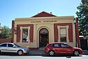
| Castlemaine Art Museum (Q55779618)
|
listed on the Victorian Heritage Register
|
Castlemaine
|
|
37°03′53″S 144°12′50″E / 37.064707°S 144.2137973°E / -37.064707; 144.2137973
|
264
|

|
| Castlemaine Cemetery (Q22919820)
|
listed on the Victorian Heritage Register
|
|
|
37°05′34″S 144°12′01″E / 37.0929°S 144.2002°E / -37.0929; 144.2002
|
5275
|
|
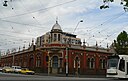
| Castlemaine Market (Q55780038)
|
listed on the Victorian Heritage Register
|
Castlemaine
|
|
37°03′57″S 144°13′05″E / 37.065972222222°S 144.218°E / -37.065972222222; 144.218
|
269
|

|
| Castlemaine North Primary School No. 2051 (Q66766196)
|
listed on the Victorian Heritage Register
|
Castlemaine
|
|
37°03′28″S 144°13′08″E / 37.0578°S 144.219°E / -37.0578; 144.219
|
5376
|
|
| Castlemaine Post Office (Q28929009)
|
listed on the Victorian Heritage Register
|
Castlemaine
|
|
37°03′53″S 144°12′51″E / 37.0648611°S 144.2140278°E / -37.0648611; 144.2140278
37°03′51″S 144°13′02″E / 37.064245°S 144.217352°E / -37.064245; 144.217352
|
5180
|

|
| Castlemaine Presbyterian Church (Q55779737)
|
listed on the Victorian Heritage Register
|
Castlemaine
|
|
37°03′51″S 144°12′57″E / 37.064166666667°S 144.21580555556°E / -37.064166666667; 144.21580555556
|
265
|

|
| Castlemaine School of Mines (Q55779791)
|
listed on the Victorian Heritage Register
|
Castlemaine
|
|
37°03′52″S 144°13′07″E / 37.064388888889°S 144.21869444444°E / -37.064388888889; 144.21869444444
|
267
|

|
| Castlemaine Uniting Church (Q56254408)
|
listed on the Victorian Heritage Register
|
Castlemaine
|
|
37°03′53″S 144°12′55″E / 37.064611111111°S 144.21522222222°E / -37.064611111111; 144.21522222222
|
2488
|

|
| Castlemaine botanic gardens (Q6451246)
|
listed on the Victorian Heritage Register
|
Castlemaine
|
|
37°03′09″S 144°12′56″E / 37.05262°S 144.21557°E / -37.05262; 144.21557
|
1791
|
|
| Catani Gardens (Q56246961)
|
listed on the Victorian Heritage Register
|
St Kilda
|
|
37°51′42″S 144°58′18″E / 37.861555555556°S 144.97158333333°E / -37.861555555556; 144.97158333333
|
1997
|

|
| Cathedral College (Q14980143)
|
listed on the Victorian Heritage Register
|
East Melbourne
|
|
37°48′32″S 144°58′52″E / 37.809°S 144.981°E / -37.809; 144.981
|
408
|

|
| Catherine McAuley College (Q5053134)
|
listed on the Victorian Heritage Register
|
|
|
36°46′00″S 144°20′00″E / 36.766666666667°S 144.33333333333°E / -36.766666666667; 144.33333333333
36°45′11″S 144°16′26″E / 36.753111111111°S 144.274°E / -36.75311111111111; 144.274
|
5467
|
|
| Catherine Reef United Company Gold Mine (Q66766496)
|
listed on the Victorian Heritage Register
|
Eaglehawk
|
|
36°43′01″S 144°14′31″E / 36.7169°S 144.242°E / -36.7169; 144.242
|
5016
|
|
| Caulfield (Q5054526)
|
listed on the Victorian Heritage Register
|
|
|
37°52′38″S 145°02′32″E / 37.8773°S 145.0423°E / -37.8773; 145.0423
|
279
|

|
| Cave Hill Limestone Quarry (Q66767534)
|
listed on the Victorian Heritage Register
|
Lilydale
|
|
37°46′03″S 145°20′20″E / 37.7674°S 145.339°E / -37.7674; 145.339
|
85447
|
|
| Cement Creek Plantation (Q117814199)
|
listed on the Victorian Heritage Register
|
East Warburton
|
|
37°43′07″S 145°45′09″E / 37.718555555556°S 145.75252777777777°E / -37.718555555555554; 145.75252777777777
|
85448
|
|
| Cemetery Reef Gully Cemetery (Q66766277)
|
listed on the Victorian Heritage Register
|
Chewton
|
|
37°04′38″S 144°15′43″E / 37.0771°S 144.262°E / -37.0771; 144.262
|
5384
|
|
| Central Cookman Quartz Gold Mine (Q66767588)
|
listed on the Victorian Heritage Register
|
Maldon
|
|
37°00′57″S 144°02′46″E / 37.0157°S 144.046°E / -37.0157; 144.046
|
5490
|
|
| Central Deborah (Q21958863)
|
listed on the Victorian Heritage Register
|
|
|
36°45′55″S 144°16′12″E / 36.765277777778°S 144.27°E / -36.765277777778; 144.27
|
5996
|
|
| Central Hall (Q5061151)
|
listed on the Victorian Heritage Register
|
Fitzroy
|
|
37°48′25″S 144°58′37″E / 37.807°S 144.977°E / -37.807; 144.977
|
4583
|

|
| Central Park (Q56251672)
|
listed on the Victorian Heritage Register
|
Stawell
|
|
37°03′31″S 142°46′26″E / 37.058527777778°S 142.77388888889°E / -37.058527777778; 142.77388888889
|
2048
|

|
| Central Park Conservatory (Q66767624)
|
listed on the Victorian Heritage Register
|
Malvern East
|
|
37°52′02″S 145°02′53″E / 37.8672°S 145.048°E / -37.8672; 145.048
|
684
|
|
| Century Building (Q66767681)
|
listed on the Victorian Heritage Register
|
Melbourne
|
|
37°48′53″S 144°57′58″E / 37.8147°S 144.966°E / -37.8147; 144.966
|
2966
|

|
| Cestria (Q66767237)
|
listed on the Victorian Heritage Register
|
Hawthorn
|
|
37°49′48″S 145°02′02″E / 37.83°S 145.034°E / -37.83; 145.034
|
4755
|
|
| Chadwick House (Q5066524)
|
listed on the Victorian Heritage Register
|
Eaglemont
|
|
37°45′57″S 145°03′47″E / 37.7659°S 145.063°E / -37.7659; 145.063
|
2080
|

|
| Chandler Highway Bridge (Q66765625)
|
listed on the Victorian Heritage Register
|
Alphington
|
|
37°47′11″S 145°01′30″E / 37.7865°S 145.025°E / -37.7865; 145.025
|
3861
|
|
| Chandos (Q66766545)
|
listed on the Victorian Heritage Register
|
East Melbourne
|
|
37°48′51″S 144°59′20″E / 37.8142°S 144.989°E / -37.8142; 144.989
|
372
|
|
| Chapel Off Chapel (Q24189485)
|
listed on the Victorian Heritage Register
|
Prahran
|
|
37°50′52″S 144°59′43″E / 37.84775°S 144.99538888889°E / -37.84775; 144.99538888889
|
2947
|
|
| Charlie Napier Hotel (Q56332135)
|
listed on the Victorian Heritage Register
|
Inglewood
|
|
36°34′26″S 143°52′03″E / 36.573972222222°S 143.86758333333°E / -36.573972222222; 143.86758333333
|
3310
|

|
| Charterisville (Q14935077)
|
listed on the Victorian Heritage Register
|
Ivanhoe
|
|
37°46′26″S 145°03′51″E / 37.774°S 145.0642°E / -37.774; 145.0642
|
4390
|
|
| Chateau Tahbilk (Q66768500)
|
listed on the Victorian Heritage Register
|
Tabilk
|
|
36°49′22″S 145°05′02″E / 36.8228°S 145.084°E / -36.8228; 145.084
|
1141
|
|
| Chateau Yering (Q66766356)
|
listed on the Victorian Heritage Register
|
Coldstream
|
|
37°40′31″S 145°22′59″E / 37.6754°S 145.383°E / -37.6754; 145.383
|
3122
|
|
| Chatsworth House (Q66766269)
|
listed on the Victorian Heritage Register
|
Chatsworth
|
|
37°51′05″S 142°37′05″E / 37.8515°S 142.618°E / -37.8515; 142.618
|
283
|
|
| Chatsworth Lodge (Q66766198)
|
listed on the Victorian Heritage Register
|
Castlemaine
|
|
37°04′35″S 144°12′14″E / 37.0763°S 144.204°E / -37.0763; 144.204
|
262
|
|
| Cheetham Saltworks (Q56618505)
|
listed on the Victorian Heritage Register
|
Moolap
|
|
38°09′52″S 144°25′11″E / 38.164555555556°S 144.41980555556°E / -38.164555555556; 144.41980555556
|
4820
|

|
| Chelsea Court House (Q56747066)
|
listed on the Victorian Heritage Register
|
Chelsea
|
|
38°03′10″S 145°06′54″E / 38.052861111111°S 145.11502777778°E / -38.052861111111; 145.11502777778
|
284
|
|
| Chevy Chase (Q66765988)
|
listed on the Victorian Heritage Register
|
Brighton
|
|
37°55′35″S 145°00′29″E / 37.9263°S 145.008°E / -37.9263; 145.008
|
162
|
|
| Chewton Post Office (Q33129715)
|
listed on the Victorian Heritage Register
|
|
|
37°04′53″S 144°15′26″E / 37.0812869°S 144.2571909°E / -37.0812869; 144.2571909
|
4640
|
|
| Chewton Town Hall (Q56257023)
|
listed on the Victorian Heritage Register
|
Chewton
|
|
37°04′53″S 144°15′25″E / 37.081277777778°S 144.25694444444°E / -37.081277777778; 144.25694444444
|
2697
|

|
| Chewton railway precinct (Q66766279)
|
listed on the Victorian Heritage Register
|
Chewton
|
|
37°05′04″S 144°15′18″E / 37.0845°S 144.255°E / -37.0845; 144.255
|
3797
|
|
| Chicory kiln (Q55691003)
|
listed on the Victorian Heritage Register
|
Maddingley
|
|
37°41′07″S 144°26′40″E / 37.685222222222°S 144.44438888889°E / -37.685222222222; 144.44438888889
|
192306
|
|
| Chiltern (Q5099215)
|
listed on the Victorian Heritage Register
|
|
|
36°09′21″S 146°36′42″E / 36.1557°S 146.6118°E / -36.1557; 146.6118
|
291
|

|
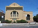
| Chiltern Athenaeum (Q56207922)
|
listed on the Victorian Heritage Register
|
Chiltern
|
|
36°09′04″S 146°36′35″E / 36.151111111111°S 146.60977777778°E / -36.151111111111; 146.60977777778
|
1570
|
|
| Chimney, Bluestone Mill (Q66768042)
|
listed on the Victorian Heritage Register
|
Mortlake
|
|
38°04′29″S 142°48′47″E / 38.0746°S 142.813°E / -38.0746; 142.813
|
853
|
|
| Chinese Brick Walls (Q66765808)
|
listed on the Victorian Heritage Register
|
Bendigo
Bendigo
|
|
36°45′29″S 144°16′26″E / 36.7581°S 144.274°E / -36.7581; 144.274
|
34761
|
|
| Chinese Kiln & Market Garden (Q66768172)
|
listed on the Victorian Heritage Register
|
North Bendigo
|
|
36°44′29″S 144°17′31″E / 36.7413°S 144.292°E / -36.7413; 144.292
|
14222
|
|
| Chinese Mission Church (Q66767683)
|
listed on the Victorian Heritage Register
|
Melbourne
|
|
37°48′43″S 144°58′01″E / 37.812°S 144.967°E / -37.812; 144.967
|
4246
|

|
| Chinese Temple (Q66768380)
|
listed on the Victorian Heritage Register
|
South Melbourne
|
|
37°50′13″S 144°57′47″E / 37.8369°S 144.963°E / -37.8369; 144.963
|
1063
|
|
| Christ Church (Q5108686)
|
listed on the Victorian Heritage Register
|
Geelong
|
|
38°09′12″S 144°21′31″E / 38.1532°S 144.3586°E / -38.1532; 144.3586
|
534
|

|
| Christ Church (Q56650612)
|
listed on the Victorian Heritage Register
|
Castlemaine
|
|
37°03′57″S 144°12′54″E / 37.065722222222°S 144.21502777778°E / -37.065722222222; 144.21502777778
|
5377
|

|
| Christ Church (Q66766459)
|
listed on the Victorian Heritage Register
|
Dingley Village
|
|
37°58′21″S 145°07′08″E / 37.9725°S 145.119°E / -37.9725; 145.119
|
336
|
|
| Christ Church (Q66768409)
|
listed on the Victorian Heritage Register
|
South Yarra
|
|
37°50′18″S 144°59′10″E / 37.8384°S 144.986°E / -37.8384; 144.986
|
1080
|
|
| Christ Church (Q66768505)
|
listed on the Victorian Heritage Register
|
Tarraville
|
|
38°38′09″S 146°43′01″E / 38.6357°S 146.717°E / -38.6357; 146.717
|
2365
|
|
| Christ Church Anglican church, Beechworth (Q55764427)
|
listed on the Victorian Heritage Register
|
Beechworth
|
|
36°21′39″S 146°41′04″E / 36.360833333333°S 146.68452777778°E / -36.360833333333; 146.68452777778
|
110
|

|
| Christ Church Anglican church, Brunswick (Q55766436)
|
listed on the Victorian Heritage Register
|
Brunswick
|
|
37°46′19″S 144°57′43″E / 37.771888888889°S 144.962°E / -37.771888888889; 144.962
|
173
|

|
| Christ Church Complex (Q66768438)
|
listed on the Victorian Heritage Register
|
St Kilda
|
|
37°51′50″S 144°58′34″E / 37.8638°S 144.976°E / -37.8638; 144.976
|
4542
|
|
| Christ Church Complex (Q66768579)
|
listed on the Victorian Heritage Register
|
Warrnambool
|
|
38°22′49″S 142°28′41″E / 38.3802°S 142.478°E / -38.3802; 142.478
|
4343
|
|
| Christ Church School Building (Q66766440)
|
listed on the Victorian Heritage Register
|
Daylesford
|
|
37°20′40″S 144°08′46″E / 37.3445°S 144.146°E / -37.3445; 144.146
|
23245
|
|
| Christian Israelite Sanctuary (Q56644330)
|
listed on the Victorian Heritage Register
|
Fitzroy
|
|
37°48′13″S 144°58′34″E / 37.80352°S 144.97622°E / -37.80352; 144.97622
|
67048 14049
67048
|

|
| Church of All Nations and Organ (Q66766153)
|
listed on the Victorian Heritage Register
|
Carlton
|
|
37°47′45″S 144°58′08″E / 37.7958°S 144.969°E / -37.7958; 144.969
|
2999
|
|
| Church of Christ (Q56015332)
|
listed on the Victorian Heritage Register
|
Melbourne central business district
|
|
37°48′38″S 144°57′50″E / 37.810555555556°S 144.96386111111°E / -37.810555555556; 144.96386111111
|
820
|
|
| Church of Christ (Q66766948)
|
listed on the Victorian Heritage Register
|
Geelong
|
|
38°09′01″S 144°21′11″E / 38.1503°S 144.353°E / -38.1503; 144.353
|
4218
|
|
| Church of St Peter and St Paul (Q66766950)
|
listed on the Victorian Heritage Register
|
Geelong
Geelong
|
|
38°08′29″S 144°21′22″E / 38.1413°S 144.356°E / -38.1413; 144.356
|
4420
|
|
| Church of The Holy Annunciation Evangelismos Church (Q66766547)
|
listed on the Victorian Heritage Register
|
East Melbourne
|
|
37°48′32″S 144°58′41″E / 37.8088°S 144.978°E / -37.8088; 144.978
|
407
|
|
| Church of The Resurrection (Q66767438)
|
listed on the Victorian Heritage Register
|
Keysborough
|
|
37°59′24″S 145°09′47″E / 37.99°S 145.163°E / -37.99; 145.163
|
162358
|
|
| Churchill Island (Q5118194)
|
listed on the Victorian Heritage Register
|
|
|
38°30′00″S 145°20′00″E / 38.5°S 145.33333333333°E / -38.5; 145.33333333333
|
4852
|

|
| City Watch House (Q66767685)
|
listed on the Victorian Heritage Register
|
Melbourne
|
|
37°48′30″S 144°57′54″E / 37.8083°S 144.965°E / -37.8083; 144.965
|
797
|
|
| Claremont (Q66768139)
|
listed on the Victorian Heritage Register
|
Newtown
|
|
38°09′12″S 144°20′06″E / 38.1532°S 144.335°E / -38.1532; 144.335
|
4152
|
|
| Clarendon Terrace (Q63565282)
|
listed on the Victorian Heritage Register
|
East Melbourne
|
|
37°48′36″S 144°59′02″E / 37.80998°S 144.98389°E / -37.80998; 144.98389
|
64555 360
64555
|

|
| Clarke Building Trinity College (Q66768203)
|
listed on the Victorian Heritage Register
|
Parkville
|
|
34°54′55″S 138°37′12″E / 34.9154°S 138.62°E / -34.9154; 138.62
|
3252
|
|
| Clayton (Q5130373)
|
listed on the Victorian Heritage Register
|
|
|
37°55′28″S 145°07′12″E / 37.9245°S 145.1201°E / -37.9245; 145.1201
|
293
|

|
| Clemson House (Q66767403)
|
listed on the Victorian Heritage Register
|
Kew
|
|
37°48′18″S 145°01′08″E / 37.8051°S 145.019°E / -37.8051; 145.019
|
12475
|
|
| Clendon Lodge (Q66768526)
|
listed on the Victorian Heritage Register
|
Toorak
|
|
37°50′32″S 145°00′50″E / 37.8423°S 145.014°E / -37.8423; 145.014
|
1159
|
|
| Clifton Hill (Q5133247)
|
listed on the Victorian Heritage Register
|
|
|
37°47′19″S 144°59′43″E / 37.7887°S 144.9954°E / -37.7887; 144.9954
|
23031 294
23031
|

|
| Clowance (Q66767134)
|
listed on the Victorian Heritage Register
|
Golden Point
|
|
37°34′15″S 143°51′40″E / 37.5707°S 143.861°E / -37.5707; 143.861
|
1487
|
|
| Cloyne (Q66768440)
|
listed on the Victorian Heritage Register
|
St Kilda
|
|
37°51′39″S 144°59′31″E / 37.8607°S 144.992°E / -37.8607; 144.992
|
1104
|
|
| Club Hotel (Q55782270)
|
listed on the Victorian Heritage Register
|
|
|
37°17′37″S 143°47′11″E / 37.293527777778°S 143.78625°E / -37.293527777778; 143.78625
|
299
|

|
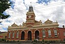
| Clunes Post Office (Q28928760)
|
listed on the Victorian Heritage Register
|
Clunes
|
|
37°17′38″S 143°47′13″E / 37.29375°S 143.7870833°E / -37.29375; 143.7870833
|
298
|

|
| Clunes Town Hall and Court House (Q56251418)
|
listed on the Victorian Heritage Register
|
Clunes
|
|
37°17′41″S 143°47′08″E / 37.294638888889°S 143.78561111111°E / -37.294638888889; 143.78561111111
|
2040
|
|
| Cobb and Co stables, Buangor (Q56706555)
|
listed on the Victorian Heritage Register
|
Buangor
|
|
37°21′58″S 143°10′24″E / 37.366°S 143.17333333333°E / -37.366; 143.17333333333
|
176
|

|
| Cobblers Gully Gold Puddling Site (Q66766281)
|
listed on the Victorian Heritage Register
|
Chewton
|
|
37°06′10″S 144°14′38″E / 37.1027°S 144.244°E / -37.1027; 144.244
|
4973
|
|
| Cobblers Gully Quartz Roasting Site (Q66766284)
|
listed on the Victorian Heritage Register
|
Chewton
|
|
37°06′09″S 144°14′35″E / 37.1026°S 144.243°E / -37.1026; 144.243
|
4998
|
|
| Cobden Terrace (Q66766744)
|
listed on the Victorian Heritage Register
|
Fitzroy
|
|
37°48′09″S 144°58′55″E / 37.8026°S 144.982°E / -37.8026; 144.982
|
459
|
|
| Cobden Terrace (Q66766745)
|
listed on the Victorian Heritage Register
|
Fitzroy
|
|
37°48′09″S 144°58′55″E / 37.8025°S 144.982°E / -37.8025; 144.982
|
460
|
|
| Cobden Terrace (Q66766748)
|
listed on the Victorian Heritage Register
|
Fitzroy
|
|
37°48′09″S 144°58′55″E / 37.8025°S 144.982°E / -37.8025; 144.982
|
461
|
|
| Cobden Terrace (Q66766749)
|
listed on the Victorian Heritage Register
|
Fitzroy
|
|
37°48′09″S 144°58′55″E / 37.8024°S 144.982°E / -37.8024; 144.982
|
462
|
|
| Cobden Terrace (Q66766752)
|
listed on the Victorian Heritage Register
|
Fitzroy
|
|
37°48′09″S 144°58′55″E / 37.8024°S 144.982°E / -37.8024; 144.982
|
463
|
|
| Cobden Terrace (Q66766754)
|
listed on the Victorian Heritage Register
|
Fitzroy
|
|
37°48′08″S 144°58′55″E / 37.8023°S 144.982°E / -37.8023; 144.982
|
464
|
|
| Cobden Terrace (Q66766757)
|
listed on the Victorian Heritage Register
|
Fitzroy
|
|
37°48′08″S 144°58′55″E / 37.8022°S 144.982°E / -37.8022; 144.982
|
465
|
|
| Cobungra Bridge (Q55668954)
|
listed on the Victorian Heritage Register
|
|
|
36°59′34″S 147°29′17″E / 36.992666666667°S 147.48813888889°E / -36.992666666667; 147.48813888889
|
5989
|

|
| Colbinabbin Community Well (Q66766352)
|
listed on the Victorian Heritage Register
|
Colbinabbin
|
|
36°31′52″S 144°44′10″E / 36.5312°S 144.736°E / -36.5312; 144.736
|
11452
|
|
| Colbinabbin Homestead (Q66766353)
|
listed on the Victorian Heritage Register
|
Colbinabbin
|
|
36°34′59″S 144°48′04″E / 36.5831°S 144.801°E / -36.5831; 144.801
|
2063
|
|
| Coliban Water Supply System (Q66768550)
|
listed on the Victorian Heritage Register
|
Tylden
|
|
36°49′10″S 144°13′34″E / 36.8195°S 144.226°E / -36.8195; 144.226
|
3784
|
|
| Collingwood Post Office (Q56420202)
|
listed on the Victorian Heritage Register
|
Collingwood
|
|
37°48′12″S 144°59′01″E / 37.803305555556°S 144.98366666667°E / -37.803305555556; 144.98366666667
|
3793
|
|
| Collingwood Town Hall (Q5147323)
|
listed on the Victorian Heritage Register
|
Abbotsford
|
|
37°48′14″S 144°59′31″E / 37.8039°S 144.992°E / -37.8039; 144.992
|
3
|

|
| Collins Settlement Site (Q66768375)
|
listed on the Victorian Heritage Register
|
Sorrento
|
|
38°20′56″S 144°45′47″E / 38.3489°S 144.763°E / -38.3489; 144.763
|
4653
|
|
| Combe Martin (Q66768033)
|
listed on the Victorian Heritage Register
|
Mornington
|
|
38°12′52″S 145°02′42″E / 38.2145°S 145.045°E / -38.2145; 145.045
|
5352
|
|
| Comet Mill (Q66766302)
|
listed on the Victorian Heritage Register
|
Clonbinane
|
|
37°22′01″S 145°09′54″E / 37.3669°S 145.165°E / -37.3669; 145.165
|
5579
|
|
| Commercial Banking Company of Sydney Ltd (Q66765810)
|
listed on the Victorian Heritage Register
|
Bendigo
|
|
36°45′31″S 144°16′41″E / 36.7586°S 144.278°E / -36.7586; 144.278
|
142
|
|
| Commercial Travellers Association Building (Q66767688)
|
listed on the Victorian Heritage Register
|
Melbourne
|
|
37°49′06″S 144°57′50″E / 37.8182°S 144.964°E / -37.8182; 144.964
|
757
|
|
| Commonwealth Memorial (Q66768474)
|
listed on the Victorian Heritage Register
|
Stawell
|
|
37°03′26″S 142°46′34″E / 37.0573°S 142.776°E / -37.0573; 142.776
|
5662
|
|
| Community of The Holy Name and Retreat House (Q66766272)
|
listed on the Victorian Heritage Register
|
Cheltenham
|
|
37°57′43″S 145°04′01″E / 37.962°S 145.067°E / -37.962; 145.067
|
12448
|
|
| Concrete Truss Footbridge (Q66766200)
|
listed on the Victorian Heritage Register
|
Castlemaine
|
|
37°03′48″S 144°12′47″E / 37.0633°S 144.213°E / -37.0633; 144.213
|
5400
|
|
| Condidorios Bridge (Q66767467)
|
listed on the Victorian Heritage Register
|
Koondrook
|
|
35°39′01″S 144°08′02″E / 35.6502°S 144.134°E / -35.6502; 144.134
|
5492
|
|
| Continental Hotel (Q56673723)
|
listed on the Victorian Heritage Register
|
Sorrento
|
|
38°20′21″S 144°44′29″E / 38.339166666667°S 144.74138888889°E / -38.339166666667; 144.74138888889
|
6081
|

|
| Convincing Ground (Q66765623)
|
listed on the Victorian Heritage Register
|
Allestree
|
|
38°16′40″S 141°39′32″E / 38.2779°S 141.659°E / -38.2779; 141.659
|
13797
|
|
| Coolart (Q66768372)
|
listed on the Victorian Heritage Register
|
Somers
|
|
38°23′09″S 145°08′35″E / 38.3859°S 145.143°E / -38.3859; 145.143
|
1030
|

|
| Coolock House (Q66765813)
|
listed on the Victorian Heritage Register
|
Bendigo
Bendigo
|
|
36°45′10″S 144°16′23″E / 36.7529°S 144.273°E / -36.7529; 144.273
|
139
|
|
| Coonanga Homestead (Q66768486)
|
listed on the Victorian Heritage Register
|
Strathmerton
|
|
35°52′25″S 145°24′14″E / 35.8737°S 145.404°E / -35.8737; 145.404
|
1129
|
|
| Corio Villa (Q66766953)
|
listed on the Victorian Heritage Register
|
Geelong
|
|
38°08′54″S 144°22′19″E / 38.1484°S 144.372°E / -38.1484; 144.372
|
523
|
|
| Coriyule Homestead (Q66766428)
|
listed on the Victorian Heritage Register
|
Curlewis
|
|
38°10′11″S 144°32′13″E / 38.1697°S 144.537°E / -38.1697; 144.537
|
342
|
|
| Correagh (Q66767204)
|
listed on the Victorian Heritage Register
|
Hamilton
|
|
37°42′27″S 142°04′12″E / 37.7074°S 142.07°E / -37.7074; 142.07
|
29871
|
|
| Costerfield Gold and Antimony Mining Precinct (Q66766380)
|
listed on the Victorian Heritage Register
|
Costerfield
|
|
36°52′46″S 144°47′38″E / 36.8794°S 144.794°E / -36.8794; 144.794
|
5104
|
|
| Cottage (Q66766021)
|
listed on the Victorian Heritage Register
|
Brunswick
|
|
37°46′38″S 144°58′12″E / 37.7773°S 144.97°E / -37.7773; 144.97
|
167
|
|
| Cottage (Q66766323)
|
listed on the Victorian Heritage Register
|
Coburg
|
|
37°44′29″S 144°58′16″E / 37.7414°S 144.971°E / -37.7414; 144.971
|
303
|
|
| Cottage (Q66768239)
|
listed on the Victorian Heritage Register
|
Port Fairy
|
|
38°23′13″S 142°13′55″E / 38.3869°S 142.232°E / -38.3869; 142.232
|
2609
|
|
| Cottage (Q66768240)
|
listed on the Victorian Heritage Register
|
Port Fairy
|
|
38°23′13″S 142°13′55″E / 38.3869°S 142.232°E / -38.3869; 142.232
|
2610
|
|
| Cottage (Q66768241)
|
listed on the Victorian Heritage Register
|
Port Fairy
|
|
38°23′13″S 142°13′55″E / 38.3869°S 142.232°E / -38.3869; 142.232
|
2836
|
|
| Cottage (Q66768242)
|
listed on the Victorian Heritage Register
|
Port Fairy
|
|
38°23′08″S 142°13′52″E / 38.3856°S 142.231°E / -38.3856; 142.231
|
13531
|
|
| Cottage (Q66768580)
|
listed on the Victorian Heritage Register
|
Warrnambool
|
|
38°23′08″S 142°29′10″E / 38.3856°S 142.486°E / -38.3856; 142.486
|
1195
|
|
| Cottage and Shop (Q66768268)
|
listed on the Victorian Heritage Register
|
Portland
|
|
38°21′03″S 141°36′14″E / 38.3508°S 141.604°E / -38.3508; 141.604
|
34621
|
|
| Cottages, Royal Freemasons Homes (Q66767690)
|
listed on the Victorian Heritage Register
|
Melbourne
|
|
37°50′51″S 144°59′02″E / 37.8474°S 144.984°E / -37.8474; 144.984
|
4435
|
|
| Court House (Q66766108)
|
listed on the Victorian Heritage Register
|
Camperdown
|
|
38°13′58″S 143°08′46″E / 38.2328°S 143.146°E / -38.2328; 143.146
|
195
|
|
| Court House (Q66768365)
|
listed on the Victorian Heritage Register
|
Skipton
|
|
37°41′11″S 143°21′47″E / 37.6864°S 143.363°E / -37.6864; 143.363
|
1025
|
|
| Court House (Q66768546)
|
listed on the Victorian Heritage Register
|
Traralgon
|
|
38°11′42″S 146°32′17″E / 38.1951°S 146.538°E / -38.1951; 146.538
|
1171
|
|
| Court House (Q66768671)
|
listed on the Victorian Heritage Register
|
Yarram
|
|
38°33′41″S 146°40′34″E / 38.5614°S 146.676°E / -38.5614; 146.676
|
1254
|
|
| Court of Appeal (Q66767692)
|
listed on the Victorian Heritage Register
|
Melbourne
|
|
37°48′49″S 144°57′32″E / 37.8136°S 144.959°E / -37.8136; 144.959
|
775
|
|
| Cowies Creek Rail Bridge No 1 (Q66765763)
|
listed on the Victorian Heritage Register
|
Bell Post Hill
|
|
38°05′16″S 144°18′18″E / 38.0879°S 144.305°E / -38.0879; 144.305
|
123526
|
|
| Cowies Creek Rail Bridge No 2 (Q66768021)
|
listed on the Victorian Heritage Register
|
Moorabool
|
|
38°04′35″S 144°18′18″E / 38.0764°S 144.305°E / -38.0764; 144.305
|
123524
|
|
| Craig & Seeley Offices and Showroom (Q66766023)
|
listed on the Victorian Heritage Register
|
Brunswick
|
|
37°45′51″S 144°57′32″E / 37.7641°S 144.959°E / -37.7641; 144.959
|
12609
|
|
| Craig's Royal Hotel (Q55758943)
|
listed on the Victorian Heritage Register
|
Ballarat
|
|
37°33′45″S 143°51′28″E / 37.562469444444°S 143.85767777778°E / -37.562469444444; 143.85767777778
|
79
|

|
| Craiglee Winery (Q66768489)
|
listed on the Victorian Heritage Register
|
Sunbury
|
|
37°35′09″S 144°44′35″E / 37.5859°S 144.743°E / -37.5859; 144.743
|
1137
|
|
| Cramond House (Q66766155)
|
listed on the Victorian Heritage Register
|
Carlton
|
|
37°48′19″S 144°58′05″E / 37.8054°S 144.968°E / -37.8054; 144.968
|
241
|
|
| Cranlana (Q66768527)
|
listed on the Victorian Heritage Register
|
Toorak
|
|
37°50′42″S 145°01′01″E / 37.8451°S 145.017°E / -37.8451; 145.017
|
3955
|
|
| Creswick (Q5184692)
|
listed on the Victorian Heritage Register
|
|
|
37°25′28″S 143°53′17″E / 37.424523518804°S 143.8881116324338°E / -37.42452351880364; 143.8881116324338
|
325
|

|
| Creswick Town Hall (Q55816187)
|
listed on the Victorian Heritage Register
|
Creswick
|
|
37°25′27″S 143°53′42″E / 37.424072°S 143.894949°E / -37.424072; 143.894949
|
322
|

|
| Criterion Hotel (Q66768351)
|
listed on the Victorian Heritage Register
|
Sale
|
|
38°06′35″S 147°04′05″E / 38.1097°S 147.068°E / -38.1097; 147.068
|
1011
|

|
| Crossroads Uniting Church (Q66768602)
|
listed on the Victorian Heritage Register
|
Werribee
|
|
37°54′09″S 144°39′47″E / 37.9026°S 144.663°E / -37.9026; 144.663
|
1206
|
|
| Crown Land Office (Q66768433)
|
listed on the Victorian Heritage Register
|
St Arnaud
|
|
36°37′04″S 143°15′36″E / 36.6178°S 143.26°E / -36.6178; 143.26
|
1086
|
|
| Ctesiphon Concrete Supermarket and Residence (Q66765648)
|
listed on the Victorian Heritage Register
|
Ashwood
|
|
37°52′03″S 145°06′18″E / 37.8675°S 145.105°E / -37.8675; 145.105
|
5210
|
|
| Cullymont (Q66766119)
|
listed on the Victorian Heritage Register
|
Canterbury
|
|
37°49′48″S 145°05′02″E / 37.83°S 145.084°E / -37.83; 145.084
|
200
|
|
| Cuming Garden (Woodbine) (Q66768528)
|
listed on the Victorian Heritage Register
|
Toorak
|
|
37°50′53″S 145°01′16″E / 37.848°S 145.021°E / -37.848; 145.021
|
12399
|
|
| Cunnacks Valonia Oak Plantation (Q66766202)
|
listed on the Victorian Heritage Register
|
Castlemaine
|
|
37°04′13″S 144°12′22″E / 37.0702°S 144.206°E / -37.0702; 144.206
|
5399
|
|
| Cunningham Dax collection (Q53858004)
|
listed on the Victorian Heritage Register
|
The Dax Centre
|
|
|
22993
|
|
| Currie and Richards Warehouse (Q66767694)
|
listed on the Victorian Heritage Register
|
Melbourne
|
|
37°48′29″S 144°57′43″E / 37.8081°S 144.962°E / -37.8081; 144.962
|
758
|
|
| Cussen Memorial (Q66767406)
|
listed on the Victorian Heritage Register
|
Kew
|
|
37°48′12″S 145°02′35″E / 37.8032°S 145.043°E / -37.8032; 145.043
|
12624
|

|
| Cyprus Terrace (Q66766549)
|
listed on the Victorian Heritage Register
|
East Melbourne
|
|
37°48′50″S 144°59′06″E / 37.8138°S 144.985°E / -37.8138; 144.985
|
376
|
|
| Cyprus Terrace (Q66766552)
|
listed on the Victorian Heritage Register
|
East Melbourne
|
|
37°48′50″S 144°59′06″E / 37.8138°S 144.985°E / -37.8138; 144.985
|
377
|
|
| Cyprus Terrace (Q66766553)
|
listed on the Victorian Heritage Register
|
East Melbourne
|
|
37°48′49″S 144°59′06″E / 37.8137°S 144.985°E / -37.8137; 144.985
|
378
|
|
| Cyprus Terrace (Q66766557)
|
listed on the Victorian Heritage Register
|
East Melbourne
|
|
37°48′49″S 144°59′06″E / 37.8137°S 144.985°E / -37.8137; 144.985
|
379
|
|
| D'Estaville (Q66767408)
|
listed on the Victorian Heritage Register
|
Kew
|
|
37°48′14″S 145°01′37″E / 37.8039°S 145.027°E / -37.8039; 145.027
|
616
|
|
| Dalkeith (Q66768381)
|
listed on the Victorian Heritage Register
|
South Melbourne
|
|
37°50′21″S 144°57′43″E / 37.8391°S 144.962°E / -37.8391; 144.962
|
1031
|
|
| Dalmeny House (Q66766157)
|
listed on the Victorian Heritage Register
|
Carlton
|
|
37°48′20″S 144°58′05″E / 37.8055°S 144.968°E / -37.8055; 144.968
|
240
|
|
| Dalys Cottage (Q66768228)
|
listed on the Victorian Heritage Register
|
Percydale
|
|
37°03′17″S 143°24′36″E / 37.0547°S 143.41°E / -37.0547; 143.41
|
1572
|
|
| Dana Street Primary School (Q56722730)
|
listed on the Victorian Heritage Register
|
Ballarat Central
|
|
37°33′51″S 143°51′13″E / 37.564138888889°S 143.85363888889°E / -37.564138888889; 143.85363888889
|
63
|

|
| Danns Bridge (Q66766493)
|
listed on the Victorian Heritage Register
|
Dunolly
|
|
36°52′43″S 143°49′59″E / 36.8787°S 143.833°E / -36.8787; 143.833
|
5982
|
|
| Darnlee (Q66768529)
|
listed on the Victorian Heritage Register
|
Toorak
|
|
37°50′18″S 145°00′58″E / 37.8382°S 145.016°E / -37.8382; 145.016
|
3570
|
|
| Darra (Q66767966)
|
listed on the Victorian Heritage Register
|
Meredith
|
|
37°48′58″S 144°08′56″E / 37.8161°S 144.149°E / -37.8161; 144.149
|
834
|
|
| Dart River Gold Battery Site (Q66768120)
|
listed on the Victorian Heritage Register
|
Nariel Valley
|
|
36°31′18″S 147°46′19″E / 36.5216°S 147.772°E / -36.5216; 147.772
|
5008
|
|
| David Jones Store (Former Buckley & Nunn) (Q66767696)
|
listed on the Victorian Heritage Register
|
Melbourne
|
|
37°48′48″S 144°57′50″E / 37.8133°S 144.964°E / -37.8133; 144.964
|
29906
|
|
| David Jones Store (Former Coles) (Q66767698)
|
listed on the Victorian Heritage Register
|
Melbourne
|
|
37°48′52″S 144°57′54″E / 37.8144°S 144.965°E / -37.8144; 144.965
|
2828
|

|
| Dawson Cactus Gardens (Q66768613)
|
listed on the Victorian Heritage Register
|
White Hills
|
|
36°43′22″S 144°18′40″E / 36.7229°S 144.311°E / -36.7229; 144.311
|
5162
|
|
| Day's Flour Mill Complex (Q66768103)
|
listed on the Victorian Heritage Register
|
Murchison
|
|
36°40′37″S 145°12′18″E / 36.6769°S 145.205°E / -36.6769; 145.205
|
862
|
|
| Daylesford Court House (Q55816197)
|
listed on the Victorian Heritage Register
|
Daylesford
|
|
37°20′31″S 144°08′46″E / 37.341927°S 144.146014°E / -37.341927; 144.146014
|
329
|
|
| De Kerilleau Homestead (Q66768644)
|
listed on the Victorian Heritage Register
|
Wodonga
|
|
36°07′02″S 146°55′05″E / 36.1171°S 146.918°E / -36.1171; 146.918
|
2700
|
|
| Deadmans Gully Burial Ground (Q66767360)
|
listed on the Victorian Heritage Register
|
Irishtown
|
|
37°08′48″S 144°14′06″E / 37.1468°S 144.235°E / -37.1468; 144.235
|
5513
|
|
| Deadmans Gully Cemetery (Q66767136)
|
listed on the Victorian Heritage Register
|
Golden Point
|
|
37°03′41″S 144°16′16″E / 37.0614°S 144.271°E / -37.0614; 144.271
|
5386
|
|
| Deanside Homestead Complex (Q66766442)
|
listed on the Victorian Heritage Register
|
Deanside
|
|
37°43′36″S 144°41′49″E / 37.7266°S 144.697°E / -37.7266; 144.697
|
992
|
|
| Deborah Company Quartz Gold Mine (Q66767167)
|
listed on the Victorian Heritage Register
|
Golden Square
|
|
36°46′23″S 144°16′23″E / 36.773°S 144.273°E / -36.773; 144.273
|
5255
|
|
| Deep Leads Electric Commission Power House (Q66766144)
|
listed on the Victorian Heritage Register
|
Carisbrook
|
|
37°00′48″S 143°54′36″E / 37.0133°S 143.91°E / -37.0133; 143.91
|
5394
|
|
| Degraves Mill (Q56734896)
|
listed on the Victorian Heritage Register
|
Kyneton
|
|
37°16′12″S 144°28′48″E / 37.270111111111°S 144.47997222222°E / -37.270111111111; 144.47997222222
|
207
|

|
| Delegate River Diversion Tunnel (Q5253589)
|
listed on the Victorian Heritage Register
|
|
|
37°09′46″S 148°47′02″E / 37.1628°S 148.784°E / -37.1628; 148.784
|
4986
|
|
| Delgany (Q66768285)
|
listed on the Victorian Heritage Register
|
Portsea
|
|
38°19′16″S 144°42′32″E / 38.3212°S 144.709°E / -38.3212; 144.709
|
2505
|
|
| Deloraine Terrace (Q56038107)
|
listed on the Victorian Heritage Register
|
Parkville
|
|
37°46′51″S 144°57′34″E / 37.780916666667°S 144.95930555556°E / -37.780916666667; 144.95930555556
|
902
|

|
| Dennys Lascelles Wool Stores (Q66766956)
|
listed on the Victorian Heritage Register
|
Geelong
|
|
38°08′43″S 144°21′40″E / 38.1454°S 144.361°E / -38.1454; 144.361
|
536
|
|
| Denton Hat Mills (Q56707453)
|
listed on the Victorian Heritage Register
|
Abbotsford
|
|
37°48′28″S 144°59′48″E / 37.807861111111°S 144.99672222222°E / -37.807861111111; 144.99672222222
|
7
|

|
| Desbrowe Annear House (Q66766500)
|
listed on the Victorian Heritage Register
|
Eaglemont
|
|
37°45′57″S 145°03′47″E / 37.7657°S 145.063°E / -37.7657; 145.063
|
2081
|
|
| Devonshire Arms Hotel (Q14935088)
|
listed on the Victorian Heritage Register
|
Fitzroy
|
|
37°48′25″S 144°58′34″E / 37.80694444°S 144.97611111°E / -37.80694444; 144.97611111
|
8677
101589 453
8677
101589
|

|
| Dhurringile (Q66766452)
|
listed on the Victorian Heritage Register
|
Dhurringile
|
|
36°31′17″S 145°13′37″E / 36.5214°S 145.227°E / -36.5214; 145.227
|
863
|
|
| Diamond House (Q66768475)
|
listed on the Victorian Heritage Register
|
Stawell
|
|
37°03′35″S 142°46′05″E / 37.0596°S 142.768°E / -37.0596; 142.768
|
14436
|
|
| Dights Mill Site (Q66765292)
|
listed on the Victorian Heritage Register
|
Abbotsford
|
|
37°47′48″S 145°00′04″E / 37.7966°S 145.001°E / -37.7966; 145.001
|
2
|
|
| Dimmeys (Q56598127)
|
listed on the Victorian Heritage Register
|
Cremorne
|
|
37°49′32″S 144°59′41″E / 37.825555555556°S 144.99469444444°E / -37.825555555556; 144.99469444444
|
4499
|
|
| Discovery of Gold Monument (Q66765815)
|
listed on the Victorian Heritage Register
|
Bendigo
Bendigo
|
|
36°45′25″S 144°16′55″E / 36.757°S 144.282°E / -36.757; 144.282
|
5148
|
|
| Dodgshun House (Q66766759)
|
listed on the Victorian Heritage Register
|
Fitzroy
|
|
37°48′27″S 144°58′37″E / 37.8074°S 144.977°E / -37.8074; 144.977
|
448
|
|
| Domain Parklands (Q56705791)
|
listed on the Victorian Heritage Register
|
Melbourne central business district
|
|
37°49′42″S 144°58′41″E / 37.8283°S 144.978°E / -37.8283; 144.978
|
165951
|
|
| Dorothy Terrace, 34 Lulie Street (Q66765436)
|
listed on the Victorian Heritage Register
|
Abbotsford
|
|
37°47′47″S 144°59′46″E / 37.7965°S 144.996°E / -37.7965; 144.996
|
4636
|
|
| Dorothy Terrace, 36 Lulie Street (Q66765439)
|
listed on the Victorian Heritage Register
|
Abbotsford
|
|
37°47′48″S 144°59′46″E / 37.7966°S 144.996°E / -37.7966; 144.996
|
4790
|
|
| Dorothy Terrace, 38 Lulie Street (Q66765441)
|
listed on the Victorian Heritage Register
|
Abbotsford
|
|
37°47′48″S 144°59′46″E / 37.7966°S 144.996°E / -37.7966; 144.996
|
4797
|
|
| Dorothy Terrace, 40 Lulie Street (Q66765442)
|
listed on the Victorian Heritage Register
|
Abbotsford
|
|
37°47′47″S 144°59′46″E / 37.7965°S 144.996°E / -37.7965; 144.996
|
4830
|
|
| Dorothy Terrace, 42 Lulie Street (Q66765444)
|
listed on the Victorian Heritage Register
|
Abbotsford
|
|
37°47′47″S 144°59′46″E / 37.7965°S 144.996°E / -37.7965; 144.996
|
4829
|
|
| Dorothy Terrace, 44 Lulie Street (Q66765447)
|
listed on the Victorian Heritage Register
|
Abbotsford
|
|
37°47′47″S 144°59′46″E / 37.7964°S 144.996°E / -37.7964; 144.996
|
4814
|
|
| Dorothy Terrace, 46 Lulie Street (Q66765449)
|
listed on the Victorian Heritage Register
|
Abbotsford
|
|
37°47′47″S 144°59′46″E / 37.7964°S 144.996°E / -37.7964; 144.996
|
4811
|
|
| Dorothy Terrace, 48 Lulie Street (Q66765451)
|
listed on the Victorian Heritage Register
|
Abbotsford
|
|
37°47′47″S 144°59′46″E / 37.7964°S 144.996°E / -37.7964; 144.996
|
4798
|
|
| Dr Crosson's Residence and Surgery (Q56447858)
|
listed on the Victorian Heritage Register
|
Echuca
|
|
36°07′29″S 144°44′52″E / 36.124638888889°S 144.74777777778°E / -36.124638888889; 144.74777777778
|
3836
|
|
| Dressing Pavilion (Q66768617)
|
listed on the Victorian Heritage Register
|
Williamstown
|
|
37°52′05″S 144°53′38″E / 37.868°S 144.894°E / -37.868; 144.894
|
1229
|
|
| Drill Hall (Q66766204)
|
listed on the Victorian Heritage Register
|
Castlemaine
|
|
37°03′51″S 144°13′05″E / 37.0643°S 144.218°E / -37.0643; 144.218
|
263
|
|
| Drill Hall and Gun Shed (Q66768269)
|
listed on the Victorian Heritage Register
|
Portland
|
|
38°21′07″S 141°36′22″E / 38.352°S 141.606°E / -38.352; 141.606
|
118368
|
|
| Dromana Drive-In (Q66766480)
|
listed on the Victorian Heritage Register
|
Dromana
|
|
38°19′47″S 144°59′46″E / 38.3297°S 144.996°E / -38.3297; 144.996
|
26683
|
|
| Drouin Primary School (Q56747921)
|
listed on the Victorian Heritage Register
|
Drouin
|
|
38°07′59″S 145°51′15″E / 38.132972222222°S 145.85413888889°E / -38.132972222222; 145.85413888889
|
340
|

|
| Drummond Terrace (Q56736101)
|
listed on the Victorian Heritage Register
|
Carlton
|
|
37°48′16″S 144°58′03″E / 37.804416666667°S 144.96758333333°E / -37.804416666667; 144.96758333333
|
211
|

|
| Dudley House (Q55765904)
|
listed on the Victorian Heritage Register
|
Bendigo
|
|
36°45′25″S 144°16′33″E / 36.757027777778°S 144.27586111111°E / -36.757027777778; 144.27586111111
|
146
|

|
| Duffy's Lime Kiln (Q66768286)
|
listed on the Victorian Heritage Register
|
Portsea
|
|
38°19′27″S 144°44′10″E / 38.3243°S 144.736°E / -38.3243; 144.736
|
6108
|
|
| Duke and Orrs Dry Dock (Q66768406)
|
listed on the Victorian Heritage Register
|
South Wharf
|
|
37°49′29″S 144°57′11″E / 37.8246°S 144.953°E / -37.8246; 144.953
|
2309
|
|
| Duke and Timor Deep Lead Gold Mine (Q66768520)
|
listed on the Victorian Heritage Register
|
Timor
|
|
36°58′56″S 143°42′47″E / 36.9822°S 143.713°E / -36.9822; 143.713
|
5061
|
|
| Duneira (Q66768076)
|
listed on the Victorian Heritage Register
|
Mount Macedon
|
|
37°22′38″S 144°35′46″E / 37.3771°S 144.596°E / -37.3771; 144.596
|
1972
|
|
| Dunolly Court House (Q55816243)
|
listed on the Victorian Heritage Register
|
Dunolly
|
|
36°51′27″S 143°44′00″E / 36.857454°S 143.733208°E / -36.857454; 143.733208
|
347
|
|
| Dunolly Town Hall (Q55816234)
|
listed on the Victorian Heritage Register
|
Dunolly
|
|
36°51′36″S 143°43′55″E / 36.860022°S 143.731858°E / -36.860022; 143.731858
|
345
|
|
| Dunolly railway station (Q5315638)
|
listed on the Victorian Heritage Register
|
|
|
36°51′49″S 143°43′46″E / 36.863611°S 143.729444°E / -36.863611; 143.729444
|
344
|
|
| Dwelling (Q66768270)
|
listed on the Victorian Heritage Register
|
Portland
|
|
38°21′08″S 141°36′18″E / 38.3523°S 141.605°E / -38.3523; 141.605
|
945
|
|
| ES&A Bank building, Ballarat (Q56726787)
|
listed on the Victorian Heritage Register
|
Ballarat Central
|
|
37°33′41″S 143°51′28″E / 37.561305555556°S 143.85763888889°E / -37.561305555556; 143.85763888889
|
69
|

|
| ES&A Bank building, Clunes (Q55782465)
|
listed on the Victorian Heritage Register
|
Clunes
|
|
37°17′36″S 143°47′09″E / 37.293333333333°S 143.78591666667°E / -37.293333333333; 143.78591666667
|
300
|

|
| ETA Foods Factory (Q5324439)
|
listed on the Victorian Heritage Register
|
Braybrook
|
|
37°46′48″S 144°51′32″E / 37.7801°S 144.859°E / -37.7801; 144.859
|
5623
|
|
| Eagle House (Q66767699)
|
listed on the Victorian Heritage Register
|
Melbourne
|
|
37°48′56″S 144°57′36″E / 37.8156°S 144.96°E / -37.8156; 144.96
|
4698
|
|
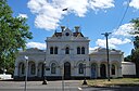
| Eaglehawk Court House and Lock-up (Q56646977)
|
listed on the Victorian Heritage Register
|
Eaglehawk
|
|
36°43′01″S 144°15′03″E / 36.716861111111°S 144.25091666667°E / -36.716861111111; 144.25091666667
|
5187
|

|
| Eaglehawk Primary School (Q56254082)
|
listed on the Victorian Heritage Register
|
Eaglehawk
|
|
36°43′14″S 144°15′16″E / 36.720444444444°S 144.25436111111°E / -36.720444444444; 144.25436111111
|
2482
|

|
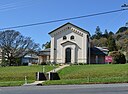
| Eaglehawk Primitive Methodist Church (Q56256778)
|
listed on the Victorian Heritage Register
|
Eaglehawk
|
|
36°43′12″S 144°15′19″E / 36.720111111111°S 144.25525°E / -36.720111111111; 144.25525
|
2511
|
|
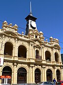
| Eaglehawk Town Hall and Mechanics Institute (Q56273576)
|
listed on the Victorian Heritage Register
|
Eaglehawk
|
|
36°43′02″S 144°15′05″E / 36.717138888889°S 144.25125°E / -36.717138888889; 144.25125
|
2847
|

|


,_Cape_Otway_Lighthouse_--_2019_--_1230.jpg)


.jpg)


_court_house.jpg)


.jpg)


.jpg)


