| Name
|
Heritage list
|
Place
|
Street address
|
Coordinates
|
place_id
|
Image
|
| Queensland Brewery Company Building (Q19877358)
|
listed on the Queensland Heritage Register
|
|
|
27°27′42″S 153°01′55″E / 27.4616°S 153.032°E / -27.4616; 153.032
|
600080
|

|
| Queensland Building (Q24189527)
|
listed on the Queensland Heritage Register
|
|
|
19°15′26″S 146°49′18″E / 19.2573°S 146.8218°E / -19.2573; 146.8218
|
600909
|
|
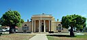
| Queensland Club (Q19877362)
|
listed on the Queensland Heritage Register
|
|
|
27°28′27″S 153°01′37″E / 27.4743°S 153.027°E / -27.4743; 153.027
|
600113
|

|
| Queensland Country Life Building facade (Q19877366)
|
listed on the Queensland Heritage Register
|
|
|
27°27′55″S 153°01′52″E / 27.4653°S 153.031°E / -27.4653; 153.031
|
600158
|

|
| Queensland Country Women's Association Girls' Hostel (Q24089866)
|
listed on the Queensland Heritage Register
|
|
|
27°36′55″S 152°45′57″E / 27.6154°S 152.7658°E / -27.6154; 152.7658
|
600558
|

|
| Queensland Cultural Centre (Q7270928)
|
listed on the Queensland Heritage Register
|
|
|
27°28′24″S 153°01′05″E / 27.4732°S 153.018°E / -27.4732; 153.018
|
602844
|

|
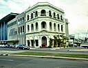
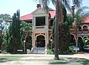
| Queensland National Bank, Charleville (Q28184276)
|
listed on the Queensland Heritage Register
|
|
|
26°24′01″S 146°14′25″E / 26.4003°S 146.2403°E / -26.4003; 146.2403
|
600757
|

|
| Queensland National Bank, Childers (Q24090248)
|
listed on the Queensland Heritage Register
|
|
|
25°14′12″S 152°16′46″E / 25.2366°S 152.2795°E / -25.2366; 152.2795
|
600610
|

|
| Queensland National Bank, Forest Hill (Q19877369)
|
listed on the Queensland Heritage Register
|
|
|
27°35′22″S 152°21′25″E / 27.5894°S 152.357°E / -27.5894; 152.357
|
600651
|

|
| Queensland National Bank, Gympie (Q24090171)
|
listed on the Queensland Heritage Register
|
|
|
26°11′18″S 152°39′32″E / 26.1882°S 152.659°E / -26.1882; 152.659
|
602773
|

|
| Queensland National Bank, Ipswich (Q24089867)
|
listed on the Queensland Heritage Register
|
|
|
27°36′51″S 152°45′39″E / 27.6143°S 152.7608°E / -27.6143; 152.7608
|
600559
|

|
| Queensland National Bank, Irvinebank (Q24882890)
|
listed on the Queensland Heritage Register
|
|
|
17°25′43″S 145°12′17″E / 17.4287°S 145.2047°E / -17.4287; 145.2047
|
600678
|

|
| Queensland National Bank, Mackay (Q24189392)
|
listed on the Queensland Heritage Register
|
|
|
21°08′29″S 149°11′10″E / 21.1415°S 149.1861°E / -21.1415; 149.1861
|
600672
|

|
| Queensland National Bank, Maryborough (Q24090216)
|
listed on the Queensland Heritage Register
|
|
|
25°32′21″S 152°42′17″E / 25.5391°S 152.7047°E / -25.5391; 152.7047
|
600694
|

|
| Queensland National Bank, Rockhampton (Q24185606)
|
listed on the Queensland Heritage Register
|
|
|
23°22′39″S 150°30′51″E / 23.3775°S 150.5141°E / -23.3775; 150.5141
|
600807
|

|
| Queensland National Bank, South Brisbane (Q19877373)
|
listed on the Queensland Heritage Register
|
|
|
27°28′26″S 153°01′05″E / 27.4739°S 153.018°E / -27.4739; 153.018
|
602134
|

|
| Queensland National Bank, Townsville (Q24189553)
|
listed on the Queensland Heritage Register
|
|
|
19°15′32″S 146°49′02″E / 19.2588°S 146.8173°E / -19.2588; 146.8173
|
600905
|

|
| Queensland National Hotel (Q24090293)
|
listed on the Queensland Heritage Register
|
|
|
23°38′45″S 150°23′11″E / 23.6459°S 150.3864°E / -23.6459; 150.3864
|
600748
|

|
| Queensland Primary Producers No 4 Woolstore (Q19877375)
|
listed on the Queensland Heritage Register
|
|
|
27°27′09″S 153°02′53″E / 27.4524°S 153.048°E / -27.4524; 153.048
|
600325
|

|
| Queensland Woollen Manufacturing Company mill (Q19877380)
|
listed on the Queensland Heritage Register
|
|
|
27°36′39″S 152°45′58″E / 27.6107°S 152.766°E / -27.6107; 152.766
|
602572
|

|
| Quetta Memorial Precinct (Q16899033)
|
listed on the Queensland Heritage Register
|
|
|
10°35′02″S 142°12′54″E / 10.5838°S 142.215°E / -10.5838; 142.215
|
602168
|

|
| R Martin & Co Building (Q19877401)
|
listed on the Queensland Heritage Register
|
|
|
27°28′16″S 153°01′48″E / 27.4711°S 153.03°E / -27.4711; 153.03
|
600099
|

|
| RAAF Operations Building Site (Q24190756)
|
listed on the Queensland Heritage Register
|
|
|
19°15′27″S 146°47′37″E / 19.2576°S 146.7937°E / -19.2576; 146.7937
|
602260
|

|
| RAN Station 9, Pinkenba (Q19877457)
|
listed on the Queensland Heritage Register
|
|
|
27°23′29″S 153°08′31″E / 27.3913°S 153.142°E / -27.3913; 153.142
|
602448
|

|
| RS Exton and Co Building (Q19878232)
|
listed on the Queensland Heritage Register
|
|
|
27°27′53″S 153°01′41″E / 27.4648°S 153.028°E / -27.4648; 153.028
|
601142
|

|
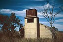
| Radar Hill, Mount Surprise (Q24895107)
|
listed on the Queensland Heritage Register
|
|
|
18°07′13″S 144°20′52″E / 18.1204°S 144.3479°E / -18.1204; 144.3479
|
602259
|

|
| Radar Station, Charlie's Hill (Q24189466)
|
listed on the Queensland Heritage Register
|
|
|
19°42′32″S 147°27′48″E / 19.7089°S 147.4632°E / -19.7089; 147.4632
|
601716
|
|
| Raglan Homestead (Q24090282)
|
listed on the Queensland Heritage Register
|
|
|
23°43′58″S 150°52′58″E / 23.7328°S 150.8828°E / -23.7328; 150.8828
|
600389
|

|
| Railway Administration Building, Rockhampton (Q24185647)
|
listed on the Queensland Heritage Register
|
|
|
23°23′06″S 150°30′51″E / 23.385°S 150.5141°E / -23.385; 150.5141
|
602367
|

|
| Railway Historical Centre (Q24089925)
|
listed on the Queensland Heritage Register
|
|
|
27°36′31″S 152°45′37″E / 27.6086°S 152.7604°E / -27.6086; 152.7604
|
600604
|

|
| Railway Hotel, Gympie (Q24041375)
|
listed on the Queensland Heritage Register
|
|
|
26°11′19″S 152°40′15″E / 26.1887°S 152.6708°E / -26.1887; 152.6708
|
602540
|
|
| Railway Hotel, Ravenswood (Q24885143)
|
listed on the Queensland Heritage Register
|
|
|
20°05′59″S 146°53′15″E / 20.0996°S 146.8874°E / -20.0996; 146.8874
|
600443
|

|
| Railway Signal Cabin and Turntable, Ipswich (Q22329537)
|
listed on the Queensland Heritage Register
|
|
|
27°36′46″S 152°45′31″E / 27.6128°S 152.7586°E / -27.6128; 152.7586
|
602464
|

|
| Raine Island Beacon (Q24998000)
|
listed on the Queensland Heritage Register
|
|
|
11°35′26″S 144°02′06″E / 11.5905°S 144.0351°E / -11.5905; 144.0351
|
600432
|

|
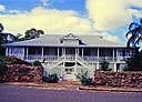
| Rainworth House, Bardon (Q19877437)
|
listed on the Queensland Heritage Register
|
|
|
27°28′00″S 152°59′24″E / 27.4667°S 152.99°E / -27.4667; 152.99
|
600282
|
|
| Ralahyne (Q19877441)
|
listed on the Queensland Heritage Register
|
|
|
27°25′28″S 153°03′22″E / 27.4245°S 153.056°E / -27.4245; 153.056
|
600182
|

|
| Range Hotel site (Q22919932)
|
listed on the Queensland Heritage Register
|
|
|
19°21′05″S 146°28′42″E / 19.3514°S 146.4782°E / -19.3514; 146.4782
|
645603
|

|
| Raspberry Creek Homestead (Q24185653)
|
listed on the Queensland Heritage Register
|
|
|
22°50′06″S 150°38′33″E / 22.8351°S 150.6426°E / -22.8351; 150.6426
|
600658
|

|
| Ravenswood Ambulance Station (Q19877478)
|
listed on the Queensland Heritage Register
|
|
|
20°06′02″S 146°53′20″E / 20.1006°S 146.889°E / -20.1006; 146.889
|
600445
|

|
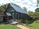
| Ravenswood Community Church (Q24885897)
|
listed on the Queensland Heritage Register
|
|
|
20°06′00″S 146°53′33″E / 20.1001°S 146.8924°E / -20.1001; 146.8924
|
601829
|

|
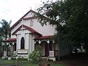
| Ravenswood Court House and Police Station (Q24885734)
|
listed on the Queensland Heritage Register
|
|
|
20°05′56″S 146°53′20″E / 20.0989°S 146.8889°E / -20.0989; 146.8889
|
601204
|

|
| Ravenswood Mining Landscape and Chinese Settlement Area (Q55631226)
|
listed on the Queensland Heritage Register
|
|
|
20°06′11″S 146°53′09″E / 20.103056°S 146.885701°E / -20.103056; 146.885701
|
650038
|

|
| Ravenswood Post Office (Q24885208)
|
listed on the Queensland Heritage Register
|
|
|
20°05′58″S 146°53′22″E / 20.0994°S 146.8895°E / -20.0994; 146.8895
|
600447
|

|
| Ravenswood School and Residence (Q24885344)
|
listed on the Queensland Heritage Register
|
|
|
20°06′15″S 146°53′23″E / 20.1041°S 146.8898°E / -20.1041; 146.8898
|
600455
|

|
| Ravenswood School of Arts (Q24885336)
|
listed on the Queensland Heritage Register
|
|
|
20°06′05″S 146°53′24″E / 20.1014°S 146.8901°E / -20.1014; 146.8901
|
600453
|

|
| Raymond Park (East) Air Raid Shelter (Q19817787)
|
listed on the Queensland Heritage Register
|
|
|
27°28′51″S 153°02′28″E / 27.4808°S 153.041°E / -27.4808; 153.041
|
602479
|

|
| Raymond Park (West) Air Raid Shelter (Q19817788)
|
listed on the Queensland Heritage Register
|
|
|
27°28′52″S 153°02′13″E / 27.4811°S 153.037°E / -27.4811; 153.037
|
602478
|

|
| Raymont Lodge (Q7299281)
|
listed on the Queensland Heritage Register
|
|
|
27°28′40″S 152°59′35″E / 27.4779°S 152.993°E / -27.4779; 152.993
|
600051
|
|
| Redcliffe Fire Station (Q24089965)
|
listed on the Queensland Heritage Register
|
|
|
27°14′09″S 153°06′28″E / 27.2357°S 153.1079°E / -27.2357; 153.1079
|
602548
|

|
| Redcliffe State High School (Q7305567)
|
listed on the Queensland Heritage Register
|
|
|
27°13′24″S 153°06′36″E / 27.2234°S 153.11°E / -27.2234; 153.11
|
650066
|
|
| Redcliffe Town Council Chambers (Q24089963)
|
listed on the Queensland Heritage Register
|
|
|
27°13′29″S 153°06′51″E / 27.2247°S 153.1141°E / -27.2247; 153.1141
|
601567
|

|
| Redland Bay State School Residence (Q19877555)
|
listed on the Queensland Heritage Register
|
|
|
27°37′09″S 153°17′35″E / 27.6191°S 153.293°E / -27.6191; 153.293
|
601369
|

|
| Rees R & Sydney Jones Building (Q24185595)
|
listed on the Queensland Heritage Register
|
|
|
23°22′38″S 150°30′50″E / 23.3772°S 150.5138°E / -23.3772; 150.5138
|
600804
|

|
| Regatta Hotel (Q7307975)
|
listed on the Queensland Heritage Register
|
|
|
27°28′57″S 152°59′47″E / 27.4825°S 152.9963°E / -27.4825; 152.9963
|
600331
|

|
| Regent Theatre (Q7308111)
|
listed on the Queensland Heritage Register
|
|
|
27°28′12″S 153°01′37″E / 27.4699°S 153.027°E / -27.4699; 153.027
|
600140
|

|
| Residence, 12 Cedar Street, Yungaburra (Q24898245)
|
listed on the Queensland Heritage Register
|
|
|
17°16′13″S 145°34′51″E / 17.2702°S 145.5809°E / -17.2702; 145.5809
|
600476
|

|
| Residence, 4 Oak Street, Yungaburra (Q24898265)
|
listed on the Queensland Heritage Register
|
|
|
17°16′04″S 145°34′53″E / 17.2677°S 145.5815°E / -17.2677; 145.5815
|
600487
|

|
| Residence, 50 Guy Street, Warwick (Q23016816)
|
listed on the Queensland Heritage Register
|
|
|
28°13′01″S 152°01′50″E / 28.2169°S 152.0305°E / -28.2169; 152.0305
|
600951
|

|
| Residence, Abbott Street (Q19817789)
|
listed on the Queensland Heritage Register
|
|
|
27°28′15″S 153°02′42″E / 27.4707°S 153.045°E / -27.4707; 153.045
|
601020
|
|
| Rewan Police Horse Breeding Station (Q86863386)
|
listed on the Queensland Heritage Register
|
Rewan
|
|
24°57′25″S 148°22′26″E / 24.957°S 148.374°E / -24.957; 148.374
|
650094
|

|
| Rhyndarra (Q16899244)
|
listed on the Queensland Heritage Register
|
|
|
27°30′53″S 153°00′18″E / 27.5147°S 153.005°E / -27.5147; 153.005
|
600360
|

|
| Richard Randall Art Studio (Q19877838)
|
listed on the Queensland Heritage Register
|
|
|
27°28′30″S 152°58′41″E / 27.475°S 152.978°E / -27.475; 152.978
|
600299
|

|
| Richmond Mill Ruins (Q24189400)
|
listed on the Queensland Heritage Register
|
|
|
21°04′54″S 149°08′45″E / 21.0816°S 149.1458°E / -21.0816; 149.1458
|
601281
|

|
| Richmond Mine and Battery (Q25248373)
|
listed on the Queensland Heritage Register
|
|
|
18°14′51″S 142°19′22″E / 18.2476°S 142.3229°E / -18.2476; 142.3229
|
601857
|

|
| Roadvale State School (Q83302800)
|
listed on the Queensland Heritage Register
|
|
|
27°55′13″S 152°42′19″E / 27.9203°S 152.7052°E / -27.9203; 152.7052
|
650095
|
|
| Rockhampton Botanic Gardens (Q5926560)
|
listed on the Queensland Heritage Register
|
|
|
23°24′03″S 150°29′29″E / 23.4007°S 150.4915°E / -23.4007; 150.4915
|
601819
|

|
| Rockhampton Club (Q24185593)
|
listed on the Queensland Heritage Register
|
|
|
23°22′36″S 150°30′49″E / 23.3768°S 150.5135°E / -23.3768; 150.5135
|
600801
|

|
| Rockhampton Courthouse (Q24090207)
|
listed on the Queensland Heritage Register
|
|
|
23°22′38″S 150°30′43″E / 23.3773°S 150.512°E / -23.3773; 150.512
|
600795
|

|
| Rockhampton Girls Grammar School (Q24090296)
|
listed on the Queensland Heritage Register
|
|
|
23°23′18″S 150°29′46″E / 23.3883°S 150.496°E / -23.3883; 150.496
|
600780
|

|
| Rockhampton Grammar School Buildings (Q28220107)
|
listed on the Queensland Heritage Register
|
|
|
23°23′04″S 150°29′39″E / 23.3845°S 150.4941°E / -23.3845; 150.4941
|
600781
|

|
| Rockhampton Harbour Board Building (Q24185616)
|
listed on the Queensland Heritage Register
|
|
|
23°22′56″S 150°31′02″E / 23.3822°S 150.5173°E / -23.3822; 150.5173
|
600816
|

|
| Rockhampton Masonic Hall (Q23022047)
|
listed on the Queensland Heritage Register
|
|
|
23°22′42″S 150°30′24″E / 23.3783°S 150.5066°E / -23.3783; 150.5066
|
601488
|

|
| Rockhampton Post Office (Q24185625)
|
listed on the Queensland Heritage Register
|
|
|
23°22′41″S 150°30′46″E / 23.3781°S 150.5129°E / -23.3781; 150.5129
|
600792
|

|
| Rockhampton Railway Workshops (Q22329539)
|
listed on the Queensland Heritage Register
|
|
|
23°23′14″S 150°31′02″E / 23.3873°S 150.5172°E / -23.3873; 150.5172
|
600783
|

|
| Rockhampton School of Arts (Q24185615)
|
listed on the Queensland Heritage Register
|
|
|
23°22′53″S 150°30′48″E / 23.3815°S 150.5134°E / -23.3815; 150.5134
|
600788
|

|
| Rockhampton Town Hall (Q23198430)
|
listed on the Queensland Heritage Register
|
|
|
23°22′55″S 150°30′49″E / 23.3819°S 150.5137°E / -23.3819; 150.5137
|
601572
|

|
| Rockhampton War Memorial (Q23003099)
|
listed on the Queensland Heritage Register
|
|
|
23°24′03″S 150°29′29″E / 23.4007°S 150.4915°E / -23.4007; 150.4915
|
600818
|

|
| Rockton, Ipswich (Q24089880)
|
listed on the Queensland Heritage Register
|
|
|
27°36′58″S 152°46′20″E / 27.6162°S 152.7721°E / -27.6162; 152.7721
|
600552
|

|
| Rocky Bluff Battery and Township (Q24882842)
|
listed on the Queensland Heritage Register
|
|
|
17°18′27″S 145°15′54″E / 17.3074°S 145.2651°E / -17.3074; 145.2651
|
601861
|

|
| Rocky Creek World War Two Hospital Complex (Q24887441)
|
listed on the Queensland Heritage Register
|
|
|
17°11′19″S 145°27′34″E / 17.1886°S 145.4594°E / -17.1886; 145.4594
|
601815
|

|
| Rodway, Toowoomba (Q18390919)
|
listed on the Queensland Heritage Register
|
|
|
27°35′03″S 151°59′20″E / 27.5842°S 151.989°E / -27.5842; 151.989
|
600868
|

|
| Roma Courthouse (Q7361476)
|
listed on the Queensland Heritage Register
|
|
|
26°34′15″S 148°47′06″E / 26.5707°S 148.785°E / -26.5707; 148.785
|
601285
|
|
| Roma Government Complex (Q28183880)
|
listed on the Queensland Heritage Register
|
|
|
26°34′12″S 148°47′26″E / 26.5701°S 148.7905°E / -26.5701; 148.7905
|
601536
|

|
| Roma War Memorial and Heroes Avenue (Q23003102)
|
listed on the Queensland Heritage Register
|
|
|
26°34′09″S 148°47′19″E / 26.5692°S 148.7886°E / -26.5692; 148.7886
|
600824
|

|
| Romavilla Winery (Q28183865)
|
listed on the Queensland Heritage Register
|
|
|
26°33′25″S 148°47′12″E / 26.557°S 148.7866°E / -26.557; 148.7866
|
601767
|

|
| Rooney Building (Q24189551)
|
listed on the Queensland Heritage Register
|
|
|
19°15′27″S 146°49′07″E / 19.2576°S 146.8185°E / -19.2576; 146.8185
|
600917
|

|
| Rosalie Community Kindergarten and Preschool (Q19878113)
|
listed on the Queensland Heritage Register
|
|
|
27°27′53″S 152°59′46″E / 27.4648°S 152.996°E / -27.4648; 152.996
|
602380
|

|
| Rosalie RSL Hall (Q19878118)
|
listed on the Queensland Heritage Register
|
|
|
27°27′55″S 152°59′49″E / 27.4654°S 152.997°E / -27.4654; 152.997
|
602517
|

|
| Rosebank (Q24189499)
|
listed on the Queensland Heritage Register
|
Mysterton
|
|
19°17′23″S 146°47′29″E / 19.2897°S 146.7914°E / -19.2897; 146.7914
|
600877
|

|
| Rosemount Hospital (Q19878137)
|
listed on the Queensland Heritage Register
|
|
|
27°26′18″S 153°01′55″E / 27.4383°S 153.032°E / -27.4383; 153.032
|
602145
|

|
| Roseville, Teneriffe (Q19878142)
|
listed on the Queensland Heritage Register
|
|
|
27°27′24″S 153°02′42″E / 27.4568°S 153.045°E / -27.4568; 153.045
|
600266
|

|
| Rosewood Courthouse (Q19945970)
|
listed on the Queensland Heritage Register
|
|
|
27°38′31″S 152°35′38″E / 27.642°S 152.594°E / -27.642; 152.594
|
601101
|

|
| Rosewood Scrub Historical Society Building (Q24089825)
|
listed on the Queensland Heritage Register
|
|
|
27°33′57″S 152°35′45″E / 27.5658°S 152.5959°E / -27.5658; 152.5959
|
600731
|

|
| Ross River Meatworks Chimney (Q7369607)
|
listed on the Queensland Heritage Register
|
|
|
19°18′18″S 146°48′14″E / 19.3051°S 146.804°E / -19.3051; 146.804
|
602719
|

|
| Rothwells Building (Q19878181)
|
listed on the Queensland Heritage Register
|
|
|
27°28′04″S 153°01′37″E / 27.4677°S 153.027°E / -27.4677; 153.027
|
600094
|

|
| Row of Street Trees, Halifax (Q24190104)
|
listed on the Queensland Heritage Register
|
|
|
18°34′51″S 146°17′05″E / 18.5808°S 146.2847°E / -18.5808; 146.2847
|
602349
|

|
| Rowes Building (Q19878193)
|
listed on the Queensland Heritage Register
|
|
|
27°28′04″S 153°01′37″E / 27.4677°S 153.027°E / -27.4677; 153.027
|
600095
|
|
| Royal Bank of Queensland, Gympie (Q24090172)
|
listed on the Queensland Heritage Register
|
|
|
26°11′20″S 152°39′36″E / 26.1889°S 152.66°E / -26.1889; 152.66
|
602774
|

|
| Royal Bank of Queensland, Lowood (Q24089940)
|
listed on the Queensland Heritage Register
|
|
|
27°27′42″S 152°34′53″E / 27.4618°S 152.5814°E / -27.4618; 152.5814
|
600496
|

|
| Royal Bank of Queensland, Maryborough (Q24090215)
|
listed on the Queensland Heritage Register
|
|
|
25°32′23″S 152°42′20″E / 25.5396°S 152.7055°E / -25.5396; 152.7055
|
600699
|

|
| Royal Bank of Queensland, Rockhampton (Q24185607)
|
listed on the Queensland Heritage Register
|
|
|
23°22′41″S 150°30′52″E / 23.3781°S 150.5144°E / -23.3781; 150.5144
|
600808
|

|
| Royal Brisbane Hospital Nurses' Homes (Q19878216)
|
listed on the Queensland Heritage Register
|
|
|
27°26′53″S 153°01′37″E / 27.4481°S 153.027°E / -27.4481; 153.027
|
600223
|

|
| Royal Bull's Head Inn (Q7373865)
|
listed on the Queensland Heritage Register
|
|
|
27°36′04″S 151°54′50″E / 27.6011°S 151.914°E / -27.6011; 151.914
|
600838
|

|
| Royal George Hotel and Ruddle's Building (Q20085684)
|
listed on the Queensland Heritage Register
|
|
|
27°27′31″S 153°02′06″E / 27.4585°S 153.035°E / -27.4585; 153.035
|
601248
|

|
| Royal Hotel, Birdsville (Q28131450)
|
listed on the Queensland Heritage Register
|
|
|
25°53′55″S 139°21′15″E / 25.8986°S 139.3542°E / -25.8986; 139.3542
|
600459
|

|
| Royal Hotel, Maryborough (Q14935551)
|
listed on the Queensland Heritage Register
|
|
|
25°32′20″S 152°42′12″E / 25.53877°S 152.70338°E / -25.53877; 152.70338
|
600700
|

|
| Royal Mail Hotel (Q28184307)
|
listed on the Queensland Heritage Register
|
|
|
28°59′51″S 144°24′33″E / 28.9976°S 144.4091°E / -28.9976; 144.4091
|
601390
|

|
| Rudd Residence (Q24090297)
|
listed on the Queensland Heritage Register
|
|
|
23°23′37″S 150°29′40″E / 23.3935°S 150.4944°E / -23.3935; 150.4944
|
601923
|

|
| Ruth Fairfax House (Q24190111)
|
listed on the Queensland Heritage Register
|
|
|
18°38′48″S 146°09′49″E / 18.6468°S 146.1636°E / -18.6468; 146.1636
|
602193
|
|
| SS Marloo (Q23582371)
|
listed on the Queensland Heritage Register
|
|
|
24°56′56″S 153°18′13″E / 24.9488°S 153.3035°E / -24.9488; 153.3035
|
800001
|
|
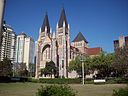
| Sacred Heart Cathedral, Townsville (Q19878311)
|
listed on the Queensland Heritage Register
|
|
|
19°15′32″S 146°48′43″E / 19.2589°S 146.812°E / -19.2589; 146.812
|
600939
|

|
| Sadliers Crossing Railway Bridge (Q18618986)
|
listed on the Queensland Heritage Register
|
|
|
27°36′52″S 152°44′24″E / 27.6145°S 152.74°E / -27.6145; 152.74
|
602569
|

|
| Saints Theodores Greek Orthodox Church (Q24189541)
|
listed on the Queensland Heritage Register
|
|
|
19°16′03″S 146°48′26″E / 19.2676°S 146.8073°E / -19.2676; 146.8073
|
601635
|

|
| Saltwater Creek Railway Bridge (Q22329540)
|
listed on the Queensland Heritage Register
|
|
|
24°51′46″S 152°21′26″E / 24.8627°S 152.3572°E / -24.8627; 152.3572
|
600370
|

|
| Saltwood (Q19878424)
|
listed on the Queensland Heritage Register
|
Shorncliffe
|
|
27°19′32″S 153°05′10″E / 27.3255°S 153.086°E / -27.3255; 153.086
|
600291
|

|
| Samuel Allen & Sons Building (Q24190070)
|
listed on the Queensland Heritage Register
|
|
|
19°15′28″S 146°49′06″E / 19.2578°S 146.8184°E / -19.2578; 146.8184
|
600903
|

|
| Sandgate Baptist Church (Q19817790)
|
listed on the Queensland Heritage Register
|
|
|
27°19′13″S 153°04′26″E / 27.3202°S 153.074°E / -27.3202; 153.074
|
602424
|

|
| Sandgate Post Office (Q24089803)
|
listed on the Queensland Heritage Register
|
|
|
27°19′16″S 153°04′08″E / 27.321°S 153.069°E / -27.321; 153.069
|
600290
|

|
| Sandgate Town Hall (Q19878460)
|
listed on the Queensland Heritage Register
|
|
|
27°19′14″S 153°04′12″E / 27.3206°S 153.07°E / -27.3206; 153.07
|
601566
|

|
| Sandgate War Memorial Park (Q19878465)
|
listed on the Queensland Heritage Register
|
|
|
27°19′14″S 153°04′12″E / 27.3206°S 153.07°E / -27.3206; 153.07
|
602454
|

|
| Sandstone Railway Culvert, North Ipswich (Q22329541)
|
listed on the Queensland Heritage Register
|
|
|
27°35′42″S 152°45′19″E / 27.5951°S 152.7552°E / -27.5951; 152.7552
|
602562
|

|
| Sandstone Railway Culvert, Wulkuraka (Q22329542)
|
listed on the Queensland Heritage Register
|
|
|
27°36′19″S 152°43′50″E / 27.6054°S 152.7306°E / -27.6054; 152.7306
|
602524
|

|
| Sandy Cape Light (Q7417192)
|
listed on the Queensland Heritage Register
|
|
|
24°43′48″S 153°12′31″E / 24.72997222°S 153.20866111°E / -24.72997222; 153.20866111
|
601712
|

|
| Santa Barbara, New Farm (Q19878736)
|
listed on the Queensland Heritage Register
|
|
|
27°28′19″S 153°02′38″E / 27.4719°S 153.044°E / -27.4719; 153.044
|
601547
|

|
| Sarina Air Raid Shelter (Q86818057)
|
listed on the Queensland Heritage Register
|
Sarina
|
|
21°25′20″S 149°13′02″E / 21.4222215°S 149.2171467°E / -21.4222215; 149.2171467
|
650229
|
|
| Sarina War Memorial (Q23003105)
|
listed on the Queensland Heritage Register
|
Sarina
|
|
21°25′27″S 149°13′04″E / 21.4243°S 149.2178°E / -21.4243; 149.2178
|
601291
|

|
| Schmidt Farmhouse (Q19878785)
|
listed on the Queensland Heritage Register
|
|
|
28°03′42″S 153°21′14″E / 28.0616°S 153.354°E / -28.0616; 153.354
|
601889
|

|
| School House, Townsville Grammar School (Q24189971)
|
listed on the Queensland Heritage Register
|
|
|
19°15′06″S 146°48′22″E / 19.2516°S 146.8061°E / -19.2516; 146.8061
|
601029
|

|
| Schotia Place (Q24185626)
|
listed on the Queensland Heritage Register
|
|
|
23°22′52″S 150°30′52″E / 23.3811°S 150.5144°E / -23.3811; 150.5144
|
600784
|

|
| Scott Street Flats (Q19817791)
|
listed on the Queensland Heritage Register
|
|
|
27°28′15″S 153°02′06″E / 27.4708°S 153.035°E / -27.4708; 153.035
|
601171
|

|
| Sea Hill Light (Q7439912)
|
listed on the Queensland Heritage Register
|
|
|
23°29′27″S 150°58′48″E / 23.4909°S 150.98°E / -23.4909; 150.98
|
602784
|

|
| Seagren's Building (Q24998032)
|
listed on the Queensland Heritage Register
|
|
|
15°28′01″S 145°15′00″E / 15.4669°S 145.25°E / -15.4669; 145.25
|
600420
|

|
| Second Innisfail Court House (Q24190480)
|
listed on the Queensland Heritage Register
|
|
|
16°48′10″S 145°43′09″E / 16.8029°S 145.7193°E / -16.8029; 145.7193
|
602500
|

|
| Second St Mary's Roman Catholic Church, Warwick (Q14935555)
|
listed on the Queensland Heritage Register
|
|
|
28°13′09″S 152°01′52″E / 28.2191°S 152.031°E / -28.2191; 152.031
|
600959
|
|
| Second Townsville General Hospital (Q29324826)
|
listed on the Queensland Heritage Register
|
|
|
19°15′08″S 146°48′47″E / 19.2523°S 146.8131°E / -19.2523; 146.8131
|
601388
|

|
| Second World War Hangar No. 7 (Q18589021)
|
listed on the Queensland Heritage Register
|
|
|
27°25′43″S 153°05′13″E / 27.4287°S 153.087°E / -27.4287; 153.087
|
601007
|

|
| Second World War RAAF Buildings, Maryborough Airport (Q21974329)
|
listed on the Queensland Heritage Register
|
|
|
25°31′03″S 152°42′40″E / 25.5176°S 152.711°E / -25.5176; 152.711
|
602556
|

|
| See Poy House (Q24190278)
|
listed on the Queensland Heritage Register
|
|
|
17°31′29″S 146°01′35″E / 17.5246°S 146.0264°E / -17.5246; 146.0264
|
602759
|

|
| Selector's Hut, Camp Mountain (Q24089970)
|
listed on the Queensland Heritage Register
|
|
|
27°23′32″S 152°52′27″E / 27.3923°S 152.8743°E / -27.3923; 152.8743
|
602654
|

|
| Selhurst, North Ward (Q24189477)
|
listed on the Queensland Heritage Register
|
|
|
19°15′19″S 146°49′06″E / 19.2552°S 146.8184°E / -19.2552; 146.8184
|
601247
|
|
| Selwyn House, Mackay (Q24189403)
|
listed on the Queensland Heritage Register
|
|
|
21°09′58″S 149°08′15″E / 21.1662°S 149.1374°E / -21.1662; 149.1374
|
601080
|

|
| Serpentine Creek Road Cemetery (Q19878847)
|
listed on the Queensland Heritage Register
|
|
|
27°40′09″S 153°18′07″E / 27.6693°S 153.302°E / -27.6693; 153.302
|
601927
|

|
| Shafston House (Q19878874)
|
listed on the Queensland Heritage Register
|
|
|
27°28′33″S 153°02′24″E / 27.4759°S 153.04°E / -27.4759; 153.04
|
600241
|

|
| Shandon, Rockhampton (Q24185632)
|
listed on the Queensland Heritage Register
|
|
|
23°22′57″S 150°30′46″E / 23.3824°S 150.5128°E / -23.3824; 150.5128
|
601492
|

|
| Shearers' Strike Camp Site, Barcaldine (Q28184235)
|
listed on the Queensland Heritage Register
|
|
|
23°31′56″S 145°19′39″E / 23.5322°S 145.3274°E / -23.5322; 145.3274
|
600019
|

|
| Shepherd Memorial Church of St Peter, Proston (Q24189968)
|
listed on the Queensland Heritage Register
|
|
|
26°09′39″S 151°36′04″E / 26.1607°S 151.6011°E / -26.1607; 151.6011
|
602813
|

|
| Sherwood Arboretum (Q18754813)
|
listed on the Queensland Heritage Register
|
|
|
27°31′52″S 152°58′30″E / 27.5311°S 152.975°E / -27.5311; 152.975
|
602456
|

|
| Sherwood State School (Q48767830)
|
listed on the Queensland Heritage Register
|
|
|
27°31′55″S 152°59′03″E / 27.531944444444°S 152.98416666667°E / -27.531944444444; 152.98416666667
|
650032
|

|
| Shop Row, Woolloongabba (Q19878965)
|
listed on the Queensland Heritage Register
|
|
|
27°29′09″S 153°01′44″E / 27.4859°S 153.029°E / -27.4859; 153.029
|
600355
|

|
| Shop adjacent to Thorps Building (Q24885712)
|
listed on the Queensland Heritage Register
|
|
|
20°06′02″S 146°53′22″E / 20.1005°S 146.8894°E / -20.1005; 146.8894
|
600454
|

|
| Shops and Cafe, Childers (Q24090252)
|
listed on the Queensland Heritage Register
|
|
|
25°14′12″S 152°16′45″E / 25.2366°S 152.2793°E / -25.2366; 152.2793
|
600612
|

|
| Signal Station (Q19878975)
|
listed on the Queensland Heritage Register
|
|
|
27°07′38″S 153°21′54″E / 27.1273°S 153.365°E / -27.1273; 153.365
|
601097
|

|
| Signals, Crane and Subway, Charters Towers Railway Station (Q24890105)
|
listed on the Queensland Heritage Register
|
|
|
20°04′36″S 146°16′17″E / 20.0768°S 146.2714°E / -20.0768; 146.2714
|
602627
|

|
| Silkstone State School (Q83302705)
|
listed on the Queensland Heritage Register
|
|
|
27°37′09″S 152°47′05″E / 27.619290469373°S 152.7847042682739°E / -27.619290469372903; 152.7847042682739
|
650091
|
|
| Silverwells (Q19878994)
|
listed on the Queensland Heritage Register
|
|
|
27°28′13″S 153°02′06″E / 27.4702°S 153.035°E / -27.4702; 153.035
|
600243
|

|
| Sinnamon Farm (Q19879015)
|
listed on the Queensland Heritage Register
|
|
|
27°32′18″S 152°57′07″E / 27.5382°S 152.952°E / -27.5382; 152.952
|
600233
|

|
| Sinnamon Memorial Uniting Church (Q19879017)
|
listed on the Queensland Heritage Register
|
|
|
27°32′18″S 152°57′07″E / 27.5382°S 152.952°E / -27.5382; 152.952
|
600235
|

|
| Sir Anthony's Rest (Q24090230)
|
listed on the Queensland Heritage Register
|
|
|
24°50′43″S 152°25′47″E / 24.8454°S 152.4296°E / -24.8454; 152.4296
|
602053
|

|
| Sir William Glasgow Memorial (Q16900231)
|
listed on the Queensland Heritage Register
|
|
|
27°28′02″S 153°01′37″E / 27.4671°S 153.027°E / -27.4671; 153.027
|
602439
|

|
| Skilmorlie (Q19879034)
|
listed on the Queensland Heritage Register
|
|
|
27°26′19″S 153°01′55″E / 27.4385°S 153.032°E / -27.4385; 153.032
|
601830
|

|
| Slab Hut Farm (Q24089814)
|
listed on the Queensland Heritage Register
|
|
|
27°25′37″S 152°52′39″E / 27.427°S 152.8776°E / -27.427; 152.8776
|
600329
|

|
| Smellie's Building (Q19879089)
|
listed on the Queensland Heritage Register
|
|
|
27°28′18″S 153°01′48″E / 27.4718°S 153.03°E / -27.4718; 153.03
|
600097
|

|
| Smithfield Chambers (Q24090168)
|
listed on the Queensland Heritage Register
|
|
|
26°11′18″S 152°39′33″E / 26.1884°S 152.6592°E / -26.1884; 152.6592
|
602777
|

|
| Smithfield House (Q18378749)
|
listed on the Queensland Heritage Register
|
|
|
27°35′08″S 151°55′44″E / 27.5855°S 151.929°E / -27.5855; 151.929
|
600854
|
|
| Soldier Settler House (Q24090286)
|
listed on the Queensland Heritage Register
|
|
|
24°23′54″S 151°19′56″E / 24.3983°S 151.3323°E / -24.3983; 151.3323
|
602229
|

|
| Soldiers Memorial Hall (Q18379128)
|
listed on the Queensland Heritage Register
|
|
|
27°33′53″S 151°57′07″E / 27.5646°S 151.952°E / -27.5646; 151.952
|
601297
|

|
| Soldiers' Memorial Hall, Ipswich (Q24089884)
|
listed on the Queensland Heritage Register
|
|
|
27°36′56″S 152°45′30″E / 27.6155°S 152.7583°E / -27.6155; 152.7583
|
600592
|
|
| Somerset Graves Site (Q50406946)
|
listed on the Queensland Heritage Register
|
|
|
10°44′27″S 142°35′33″E / 10.7409°S 142.5925°E / -10.7409; 142.5925
|
650072
|
|
| South African War Memorial, Brisbane (Q19879187)
|
listed on the Queensland Heritage Register
|
|
|
27°28′00″S 153°01′37″E / 27.4666°S 153.027°E / -27.4666; 153.027
|
600060
|
|
| South Brisbane Cemetery (Q7566408)
|
listed on the Queensland Heritage Register
|
|
|
27°29′57″S 153°01′28″E / 27.49919444°S 153.02436389°E / -27.49919444; 153.02436389
|
602406
|

|
| South Brisbane Dry Dock (Q29025004)
|
listed on the Queensland Heritage Register
|
|
|
27°28′55″S 153°01′36″E / 27.4819°S 153.0267°E / -27.4819; 153.0267
|
600301
|

|
| South Brisbane Library (Q19879220)
|
listed on the Queensland Heritage Register
|
|
|
27°28′57″S 153°01′34″E / 27.4826°S 153.026°E / -27.4826; 153.026
|
600302
|

|
| South Brisbane Railway Easement (Q18619346)
|
listed on the Queensland Heritage Register
|
|
|
27°28′55″S 153°01′37″E / 27.4819°S 153.027°E / -27.4819; 153.027
|
600293
|

|
| South Brisbane Town Hall (Q7566407)
|
listed on the Queensland Heritage Register
|
|
|
27°29′00″S 153°01′31″E / 27.4833°S 153.0254°E / -27.4833; 153.0254
|
600306
|
|
| South Brisbane railway station (Q7566410)
|
listed on the Queensland Heritage Register
|
|
|
27°28′30″S 153°01′07″E / 27.475°S 153.0186°E / -27.475; 153.0186
|
600307
|

|
| South Burnett Co-operative Dairy Association Factory (Q28184148)
|
listed on the Queensland Heritage Register
|
|
|
26°14′54″S 151°56′16″E / 26.2483°S 151.9377°E / -26.2483; 151.9377
|
602811
|
|
| South Rockhampton Cemetery (Q22919953)
|
listed on the Queensland Heritage Register
|
|
|
23°23′56″S 150°30′12″E / 23.3988°S 150.5032°E / -23.3988; 150.5032
|
601131
|

|
| South Sea Islander Church (Q24090231)
|
listed on the Queensland Heritage Register
|
|
|
24°52′52″S 152°19′18″E / 24.8812°S 152.3216°E / -24.8812; 152.3216
|
602052
|

|
| South Sea Islander Wall (Q24090223)
|
listed on the Queensland Heritage Register
|
|
|
24°48′06″S 152°26′17″E / 24.8016°S 152.4381°E / -24.8016; 152.4381
|
602230
|

|
| Southport Bathing Pavilion (Q23035869)
|
listed on the Queensland Heritage Register
|
|
|
27°57′44″S 153°24′49″E / 27.9621°S 153.4135°E / -27.9621; 153.4135
|
601514
|

|
| Southport Cable Hut (Q19879288)
|
listed on the Queensland Heritage Register
|
|
|
27°59′01″S 153°25′44″E / 27.9836°S 153.429°E / -27.9836; 153.429
|
602611
|

|
| Southport Drill Hall (Q19879292)
|
listed on the Queensland Heritage Register
|
|
|
27°58′15″S 153°24′07″E / 27.9709°S 153.402°E / -27.9709; 153.402
|
601479
|

|
| Southport State High School Buildings (Q55633624)
|
listed on the Queensland Heritage Register
|
|
|
27°57′43″S 153°24′12″E / 27.961936°S 153.403402°E / -27.961936; 153.403402
|
650034
|

|
| Southport Town Hall (Q19879296)
|
listed on the Queensland Heritage Register
|
|
|
27°58′04″S 153°24′47″E / 27.9677°S 153.413°E / -27.9677; 153.413
|
601649
|

|
| Spencers Building (Q19817792)
|
listed on the Queensland Heritage Register
|
|
|
27°28′16″S 153°01′48″E / 27.471°S 153.03°E / -27.471; 153.03
|
600100
|

|
| Spicers Gap Road (Q24089844)
|
listed on the Queensland Heritage Register
|
|
|
28°04′55″S 152°24′42″E / 28.0819°S 152.4117°E / -28.0819; 152.4117
|
601732
|

|
| Spinifex State College Junior Campus (Q83230963)
|
listed on the Queensland Heritage Register
|
|
|
20°44′03″S 139°29′12″E / 20.7341°S 139.4866°E / -20.7341; 139.4866
|
650065
|
|
| Splitters Creek Railway Bridge (Q22329545)
|
listed on the Queensland Heritage Register
|
|
|
24°51′46″S 152°17′09″E / 24.8628°S 152.2859°E / -24.8628; 152.2859
|
600529
|

|
| Spring Hill Baths (Q19879336)
|
listed on the Queensland Heritage Register
|
|
|
27°27′36″S 153°01′16″E / 27.4599°S 153.021°E / -27.4599; 153.021
|
600313
|

|
| Spring Hill Reservoirs (Q7580596)
|
listed on the Queensland Heritage Register
|
|
|
27°27′57″S 153°01′23″E / 27.4659°S 153.023°E / -27.4659; 153.023
|
600174
|

|
| Springbrook Road (Q18619706)
|
listed on the Queensland Heritage Register
|
|
|
28°09′49″S 153°17′13″E / 28.1635°S 153.287°E / -28.1635; 153.287
|
602140
|

|
| Springbrook State School (Q19879342)
|
listed on the Queensland Heritage Register
|
|
|
28°12′36″S 153°16′16″E / 28.2099°S 153.271°E / -28.2099; 153.271
|
602141
|

|
| Springsure Hospital Museum (Q28183812)
|
listed on the Queensland Heritage Register
|
|
|
24°07′10″S 148°05′04″E / 24.1194°S 148.0844°E / -24.1194; 148.0844
|
600025
|

|
| St Agnes Anglican Church, Esk (Q16900461)
|
listed on the Queensland Heritage Register
|
|
|
27°14′27″S 152°25′23″E / 27.2407°S 152.423°E / -27.2407; 152.423
|
600493
|

|
| St Andrew's Church Hall, Toogoolawah (Q24089951)
|
listed on the Queensland Heritage Register
|
|
|
27°05′24″S 152°22′34″E / 27.0901°S 152.376°E / -27.0901; 152.376
|
600500
|

|
| St Andrew's Presbyterian Church, Rockhampton (Q24185627)
|
listed on the Queensland Heritage Register
|
|
|
23°22′58″S 150°30′53″E / 23.3829°S 150.5147°E / -23.3829; 150.5147
|
600785
|

|
| St Andrew's Presbyterian Memorial Church, Innisfail (Q24189967)
|
listed on the Queensland Heritage Register
|
|
|
17°31′11″S 146°01′45″E / 17.5197°S 146.0293°E / -17.5197; 146.0293
|
602332
|

|
| St Andrew's Rectory, Toogoolawah (Q24089952)
|
listed on the Queensland Heritage Register
|
|
|
27°05′25″S 152°22′34″E / 27.0904°S 152.376°E / -27.0904; 152.376
|
600501
|

|
| St Andrews Anglican Church, South Brisbane (Q16900457)
|
listed on the Queensland Heritage Register
|
|
|
27°28′54″S 153°01′08″E / 27.4817°S 153.019°E / -27.4817; 153.019
|
600304
|

|
| St Andrews Church Hall (Q19817793)
|
listed on the Queensland Heritage Register
|
|
|
27°30′12″S 152°58′48″E / 27.5032°S 152.98°E / -27.5032; 152.98
|
600231
|
|
| St Andrews Church, Ormiston (Q19879364)
|
listed on the Queensland Heritage Register
|
|
|
27°30′10″S 153°15′29″E / 27.5028°S 153.258°E / -27.5028; 153.258
|
600774
|

|
| St Andrews Presbyterian Church, Esk (Q20712981)
|
listed on the Queensland Heritage Register
|
|
|
27°14′34″S 152°25′31″E / 27.2427°S 152.4253°E / -27.2427; 152.4253
|
602408
|

|
| St Andrews Uniting Church, Bundaberg (Q24090233)
|
listed on the Queensland Heritage Register
|
|
|
24°52′03″S 152°20′47″E / 24.8676°S 152.3465°E / -24.8676; 152.3465
|
602489
|

|
| St Andrews War Memorial Hospital Administration Building (Q19879368)
|
listed on the Queensland Heritage Register
|
|
|
27°27′42″S 153°01′16″E / 27.4616°S 153.021°E / -27.4616; 153.021
|
602170
|

|
| St Annes Anglican Church, Jondaryan (Q18331694)
|
listed on the Queensland Heritage Register
|
|
|
27°22′47″S 151°35′10″E / 27.3798°S 151.586°E / -27.3798; 151.586
|
600634
|

|
| St Aubins, Rockhampton (Q24185644)
|
listed on the Queensland Heritage Register
|
|
|
23°22′29″S 150°28′49″E / 23.3748°S 150.4802°E / -23.3748; 150.4802
|
600790
|

|
| St Augustines Anglican Church, Leyburn (Q24089843)
|
listed on the Queensland Heritage Register
|
|
|
28°00′32″S 151°35′12″E / 28.0088°S 151.5868°E / -28.0088; 151.5868
|
600828
|

|
| St Brigid's Church, Red Hill (Q7592726)
|
listed on the Queensland Heritage Register
|
|
|
27°27′27″S 153°00′36″E / 27.4574°S 153.01°E / -27.4574; 153.01
|
600284
|

|
| St Brigid's Church, Stuart (Q24189919)
|
listed on the Queensland Heritage Register
|
|
|
19°20′56″S 146°50′05″E / 19.3489°S 146.8346°E / -19.3489; 146.8346
|
600881
|

|
| St Brigid's Convent, Red Hill (Q19879371)
|
listed on the Queensland Heritage Register
|
|
|
27°27′24″S 153°00′43″E / 27.4568°S 153.012°E / -27.4568; 153.012
|
601078
|

|
| St Brigids Catholic Church, Rosewood (Q24089827)
|
listed on the Queensland Heritage Register
|
|
|
27°38′27″S 152°35′40″E / 27.6408°S 152.5944°E / -27.6408; 152.5944
|
600736
|

|
| St Christopher's Chapel, Queensland (Q24185652)
|
listed on the Queensland Heritage Register
|
|
|
23°25′20″S 150°36′14″E / 23.4223°S 150.6038°E / -23.4223; 150.6038
|
600660
|

|
| St Columba's Church Bell Tower (Q24895754)
|
listed on the Queensland Heritage Register
|
|
|
20°04′38″S 146°15′42″E / 20.0772°S 146.2617°E / -20.0772; 146.2617
|
600399
|

|
| St Columba's Convent, Dalby (Q28183977)
|
listed on the Queensland Heritage Register
|
|
|
27°11′11″S 151°15′39″E / 27.1864°S 151.2607°E / -27.1864; 151.2607
|
602761
|

|
| St David's Anglican Church, Mossman (Q24190320)
|
listed on the Queensland Heritage Register
|
|
|
16°27′30″S 145°22′23″E / 16.4583°S 145.3731°E / -16.4583; 145.3731
|
602760
|

|
| St Davids Anglican Church, Allora (Q24089839)
|
listed on the Queensland Heritage Register
|
|
|
28°02′09″S 151°59′24″E / 28.0358°S 151.9899°E / -28.0358; 151.9899
|
602061
|

|
| St Denys Anglican Church (Q24089840)
|
listed on the Queensland Heritage Register
|
|
|
28°35′26″S 151°48′31″E / 28.5906°S 151.8087°E / -28.5906; 151.8087
|
602530
|

|
| St Francis Xavier Church, Goodna (Q19879376)
|
listed on the Queensland Heritage Register
|
|
|
27°36′38″S 152°54′00″E / 27.6106°S 152.9°E / -27.6106; 152.9
|
600553
|

|
| St George's Anglican Church, Beenleigh (Q19879382)
|
listed on the Queensland Heritage Register
|
|
|
27°43′24″S 153°12′47″E / 27.7234°S 153.213°E / -27.7234; 153.213
|
600001
|

|
| St George's Anglican Church, Eumundi (Q24089981)
|
listed on the Queensland Heritage Register
|
|
|
26°28′21″S 152°57′04″E / 26.4725°S 152.951°E / -26.4725; 152.951
|
601239
|

|
| St George's Masonic Centre, Warwick (Q21017115)
|
listed on the Queensland Heritage Register
|
|
|
28°13′01″S 152°01′50″E / 28.217°S 152.0305°E / -28.217; 152.0305
|
600952
|

|
| St Helena Island National Park (Q2316148)
|
listed on the Queensland Heritage Register
|
|
|
27°23′36″S 153°13′54″E / 27.39333333°S 153.23166667°E / -27.39333333; 153.23166667
|
600315
|
|
| St Isidore's (Q24089986)
|
listed on the Queensland Heritage Register
|
|
|
26°37′11″S 152°51′55″E / 26.6197°S 152.8654°E / -26.6197; 152.8654
|
601467
|

|
| St James Catholic Church, Malanda (Q24887217)
|
listed on the Queensland Heritage Register
|
|
|
17°21′13″S 145°35′21″E / 17.3536°S 145.5891°E / -17.3536; 145.5891
|
601283
|

|
| St James Church, Toowoomba (Q18392719)
|
listed on the Queensland Heritage Register
|
|
|
27°33′28″S 151°56′56″E / 27.5579°S 151.949°E / -27.5579; 151.949
|
601298
|

|
| St James Parish Hall, Toowoomba (Q18392720)
|
listed on the Queensland Heritage Register
|
|
|
27°33′31″S 151°56′56″E / 27.5586°S 151.949°E / -27.5586; 151.949
|
600856
|

|
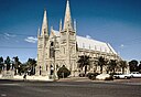
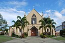
| St James' Cathedral, Townsville (Q7593418)
|
listed on the Queensland Heritage Register
|
|
|
19°15′20″S 146°49′01″E / 19.2556°S 146.817°E / -19.2556; 146.817
|
600887
|

|
| St John the Baptist Anglican Church, Bulimba (Q19879389)
|
listed on the Queensland Heritage Register
|
|
|
27°27′06″S 153°03′36″E / 27.4517°S 153.06°E / -27.4517; 153.06
|
601174
|

|
| St John the Baptist Anglican Church, Richmond (Q26258324)
|
listed on the Queensland Heritage Register
|
|
|
20°43′48″S 143°08′28″E / 20.7301°S 143.141°E / -20.7301; 143.141
|
601714
|

|
| St John's Anglican Church, Dalby (Q16900495)
|
listed on the Queensland Heritage Register
|
|
|
27°11′02″S 151°15′47″E / 27.184°S 151.263°E / -27.184; 151.263
|
602399
|

|
| St John's Anglican Church, South Townsville (Q24189904)
|
listed on the Queensland Heritage Register
|
|
|
19°15′48″S 146°49′41″E / 19.2634°S 146.828°E / -19.2634; 146.828
|
600880
|

|
| St John's Cathedral (Q1566208)
|
listed on the Queensland Heritage Register
|
|
|
27°27′50″S 153°01′48″E / 27.464°S 153.03°E / -27.464; 153.03
|
600076
|
|
| St John's Church, Mundoolun (Q19720755)
|
listed on the Queensland Heritage Register
|
|
|
27°54′06″S 153°05′20″E / 27.9017°S 153.089°E / -27.9017; 153.089
|
601082
|

|
| St John's Church, Rockhampton (Q24185645)
|
listed on the Queensland Heritage Register
|
|
|
23°21′18″S 150°31′35″E / 23.3549°S 150.5264°E / -23.3549; 150.5264
|
602342
|

|
| St John's Lutheran Church, Bundaberg (Q24090234)
|
listed on the Queensland Heritage Register
|
|
|
24°52′11″S 152°21′42″E / 24.8698°S 152.3617°E / -24.8698; 152.3617
|
602815
|

|
| St John's Wood House, Ashgrove (Q19879392)
|
listed on the Queensland Heritage Register
|
|
|
27°26′45″S 152°58′19″E / 27.4459°S 152.972°E / -27.4459; 152.972
|
601506
|

|
| St Joseph's Convent, Cairns (Q24190718)
|
listed on the Queensland Heritage Register
|
|
|
16°55′02″S 145°46′22″E / 16.9173°S 145.7729°E / -16.9173; 145.7729
|
601749
|

|
| St Josephs Cathedral, Rockhampton (Q23009385)
|
listed on the Queensland Heritage Register
|
|
|
23°23′10″S 150°30′23″E / 23.3862°S 150.5065°E / -23.3862; 150.5065
|
600822
|
|
| St Josephs Church, North Ward (Q24189575)
|
listed on the Queensland Heritage Register
|
|
|
19°15′12″S 146°49′03″E / 19.2532°S 146.8175°E / -19.2532; 146.8175
|
602130
|

|
| St Lawrence Police Station (Q24185664)
|
listed on the Queensland Heritage Register
|
|
|
22°20′38″S 149°31′42″E / 22.344°S 149.5284°E / -22.344; 149.5284
|
601152
|

|
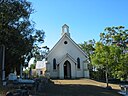
| St Luke's Anglican Church, Boyne Island (Q24090267)
|
listed on the Queensland Heritage Register
|
Boyne Island
|
|
23°57′21″S 151°21′04″E / 23.9557°S 151.351°E / -23.9557; 151.351
|
600385
|

|
| St Luke's Anglican Church, Toowoomba (Q16900494)
|
listed on the Queensland Heritage Register
|
|
|
27°33′55″S 151°57′11″E / 27.5652°S 151.953°E / -27.5652; 151.953
|
601878
|

|
| St Luke's Church Hall (Q18392723)
|
listed on the Queensland Heritage Register
|
|
|
27°33′57″S 151°57′11″E / 27.5657°S 151.953°E / -27.5657; 151.953
|
600866
|

|
| St Luke's Church of England, Brisbane (Q7755977)
|
listed on the Queensland Heritage Register
|
|
|
27°28′20″S 153°01′30″E / 27.4722°S 153.025°E / -27.4722; 153.025
|
600083
|

|
| St Mark's Anglican Church and Dunwich Public Hall (Q19879398)
|
listed on the Queensland Heritage Register
|
|
|
27°30′02″S 153°24′14″E / 27.5005°S 153.404°E / -27.5005; 153.404
|
601163
|

|
| St Mark's Anglican Church, Warwick (Q16900493)
|
listed on the Queensland Heritage Register
|
|
|
28°12′58″S 152°02′06″E / 28.216°S 152.035°E / -28.216; 152.035
|
600943
|

|
| St Marks Anglican Church, Yungaburra (Q24894823)
|
listed on the Queensland Heritage Register
|
|
|
17°16′06″S 145°34′56″E / 17.2684°S 145.5822°E / -17.2684; 145.5822
|
600484
|

|
| St Marks Church, Rockhampton (Q24185633)
|
listed on the Queensland Heritage Register
|
|
|
23°23′34″S 150°30′15″E / 23.3928°S 150.5041°E / -23.3928; 150.5041
|
602031
|
|
| St Martin's House (Q16932711)
|
listed on the Queensland Heritage Register
|
|
|
27°27′51″S 153°01′47″E / 27.4642°S 153.0297°E / -27.4642; 153.0297
|
600075
|

|
| St Mary's Anglican Church, Kangaroo Point (Q16900497)
|
listed on the Queensland Heritage Register
|
|
|
27°28′30″S 153°02′06″E / 27.475°S 153.035°E / -27.475; 153.035
|
600244
|

|
| St Mary's Anglican Church, Mount Morgan (Q24090294)
|
listed on the Queensland Heritage Register
|
|
|
23°38′47″S 150°23′12″E / 23.6463°S 150.3866°E / -23.6463; 150.3866
|
601690
|

|
| St Mary's Church & Convent, Townsville (Q24189556)
|
listed on the Queensland Heritage Register
|
|
|
19°16′09″S 146°48′09″E / 19.2692°S 146.8026°E / -19.2692; 146.8026
|
600879
|

|
| St Mary's Presbytery, Warwick (Q20747491)
|
listed on the Queensland Heritage Register
|
|
|
28°13′08″S 152°01′58″E / 28.2188°S 152.0328°E / -28.2188; 152.0328
|
602585
|

|
| St Mary's Roman Catholic Church (Maryborough, Queensland) (Q16900483)
|
listed on the Queensland Heritage Register
|
|
|
25°32′14″S 152°42′11″E / 25.5373°S 152.703°E / -25.5373; 152.703
|
600692
|
|
| St Mary's Roman Catholic Church, Ipswich (Q22059277)
|
listed on the Queensland Heritage Register
|
|
|
27°36′36″S 152°45′22″E / 27.61°S 152.7561°E / -27.61; 152.7561
|
600577
|

|
| St Mary's by the Sea, Port Douglas (Q24997946)
|
listed on the Queensland Heritage Register
|
|
|
16°28′46″S 145°27′44″E / 16.4795°S 145.4621°E / -16.4795; 145.4621
|
600464
|

|
| St Matthew's Anglican Church, Drayton (Q16900492)
|
listed on the Queensland Heritage Register
|
|
|
27°35′56″S 151°54′43″E / 27.599°S 151.912°E / -27.599; 151.912
|
600837
|

|
| St Matthews Anglican Church (Q16900502)
|
listed on the Queensland Heritage Register
|
|
|
27°24′32″S 152°58′05″E / 27.409°S 152.968°E / -27.409; 152.968
|
600256
|
|
| St Michael and All Angels Church, Kingaroy (Q26258327)
|
listed on the Queensland Heritage Register
|
|
|
26°32′28″S 151°50′27″E / 26.541°S 151.8407°E / -26.541; 151.8407
|
602763
|

|
| St Michaels Nursing Home (Q24089871)
|
listed on the Queensland Heritage Register
|
|
|
27°37′05″S 152°46′16″E / 27.618°S 152.7712°E / -27.618; 152.7712
|
600573
|

|
| St Monica's High School Administration Building (Q24190722)
|
listed on the Queensland Heritage Register
|
|
|
16°55′03″S 145°46′23″E / 16.9176°S 145.7731°E / -16.9176; 145.7731
|
601748
|

|
| St Monica's Old Cathedral, Cairns (Q23931613)
|
listed on the Queensland Heritage Register
|
|
|
16°55′02″S 145°46′20″E / 16.9171°S 145.7721°E / -16.9171; 145.7721
|
601750
|

|
| St Monica's War Memorial Cathedral (Q23324328)
|
listed on the Queensland Heritage Register
|
|
|
16°55′02″S 145°46′21″E / 16.9171°S 145.7726°E / -16.9171; 145.7726
|
601961
|

|
| St Nicholas Russian Orthodox Cathedral (Q19879402)
|
listed on the Queensland Heritage Register
|
|
|
27°29′02″S 153°02′06″E / 27.484°S 153.035°E / -27.484; 153.035
|
600358
|

|
| St Patrick's Catholic Church, Brandon (Q24189458)
|
listed on the Queensland Heritage Register
|
|
|
19°33′18″S 147°21′11″E / 19.5551°S 147.3531°E / -19.5551; 147.3531
|
600372
|

|
| St Patrick's Church, Rosevale (Q19879406)
|
listed on the Queensland Heritage Register
|
|
|
27°51′01″S 152°28′44″E / 27.8502°S 152.479°E / -27.8502; 152.479
|
602735
|

|
| St Patrick's Convent, North Ward (Q24189903)
|
listed on the Queensland Heritage Register
|
|
|
19°15′10″S 146°49′03″E / 19.2527°S 146.8176°E / -19.2527; 146.8176
|
602796
|

|
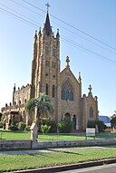
| St Patricks Cathedral, Toowoomba (Q21235761)
|
listed on the Queensland Heritage Register
|
|
|
27°34′11″S 151°57′14″E / 27.5696°S 151.954°E / -27.5696; 151.954
|
600844
|

|
| St Patricks Church, Fortitude Valley (Q19817794)
|
listed on the Queensland Heritage Register
|
|
|
27°27′28″S 153°02′17″E / 27.4577°S 153.038°E / -27.4577; 153.038
|
600210
|

|
| St Patricks Church, Gympie (Q24090170)
|
listed on the Queensland Heritage Register
|
|
|
26°11′33″S 152°39′57″E / 26.1926°S 152.6657°E / -26.1926; 152.6657
|
601503
|

|
| St Patricks Church, Mount Perry (Q28184077)
|
listed on the Queensland Heritage Register
|
|
|
25°10′47″S 151°38′32″E / 25.1798°S 151.6421°E / -25.1798; 151.6421
|
600764
|

|
| St Paul's Anglican Church, East Brisbane (Q19817795)
|
listed on the Queensland Heritage Register
|
|
|
27°29′08″S 153°02′42″E / 27.4856°S 153.045°E / -27.4856; 153.045
|
602826
|

|
| St Paul's Anglican Church, Proserpine (Q24189450)
|
listed on the Queensland Heritage Register
|
|
|
20°24′06″S 148°34′48″E / 20.4017°S 148.58°E / -20.4017; 148.58
|
601589
|

|
| St Paul's Cathedral Hall, Rockhampton (Q24185631)
|
listed on the Queensland Heritage Register
|
|
|
23°22′56″S 150°30′43″E / 23.3821°S 150.5119°E / -23.3821; 150.5119
|
601491
|

|
| St Paul's Cathedral, Rockhampton (Q7595108)
|
listed on the Queensland Heritage Register
|
|
|
23°22′53″S 150°30′47″E / 23.3815°S 150.513°E / -23.3815; 150.513
|
600821
|

|
| St Paul's Uniting Church, Mackay (Q24189406)
|
listed on the Queensland Heritage Register
|
|
|
21°08′31″S 149°11′01″E / 21.142°S 149.1836°E / -21.142; 149.1836
|
600668
|

|
| St Paul's Young Men's Club, Ipswich (Q24089874)
|
listed on the Queensland Heritage Register
|
|
|
27°36′53″S 152°45′32″E / 27.6147°S 152.759°E / -27.6147; 152.759
|
600584
|

|
| St Pauls Anglican Church, Cleveland (Q19879416)
|
listed on the Queensland Heritage Register
|
|
|
27°31′26″S 153°17′02″E / 27.5239°S 153.284°E / -27.5239; 153.284
|
600769
|

|
| St Pauls Anglican Church, Ipswich (Q24089870)
|
listed on the Queensland Heritage Register
|
|
|
27°36′52″S 152°45′30″E / 27.6145°S 152.7582°E / -27.6145; 152.7582
|
600591
|

|
| St Pauls Anglican Church, Maryborough (Q24090220)
|
listed on the Queensland Heritage Register
|
|
|
25°32′20″S 152°42′03″E / 25.5388°S 152.7008°E / -25.5388; 152.7008
|
600705
|

|
| St Pauls Presbyterian Church Hall, Spring Hill (Q19817797)
|
listed on the Queensland Heritage Register
|
|
|
27°27′39″S 153°01′37″E / 27.4607°S 153.027°E / -27.4607; 153.027
|
600310
|

|
| St Pauls Presbyterian Church, Spring Hill (Q19817798)
|
listed on the Queensland Heritage Register
|
|
|
27°27′39″S 153°01′37″E / 27.4607°S 153.027°E / -27.4607; 153.027
|
600309
|

|
| St Peter's Anglican Church, Barcaldine (Q24090089)
|
listed on the Queensland Heritage Register
|
|
|
23°33′18″S 145°17′14″E / 23.555°S 145.2873°E / -23.555; 145.2873
|
600022
|

|
| St Saviour's Anglican Church, South Johnstone (Q24190290)
|
listed on the Queensland Heritage Register
|
|
|
17°35′52″S 145°59′42″E / 17.5979°S 145.9949°E / -17.5979; 145.9949
|
602431
|

|
| St Stephen's Church, Ipswich (Q20083756)
|
listed on the Queensland Heritage Register
|
|
|
27°36′59″S 152°45′46″E / 27.6164°S 152.7629°E / -27.6164; 152.7629
|
600580
|

|
| St Stephens School, Brisbane (Q19879420)
|
listed on the Queensland Heritage Register
|
|
|
27°28′09″S 153°01′44″E / 27.4691°S 153.029°E / -27.4691; 153.029
|
600106
|

|
| St Thomas Church of England (Q19879424)
|
listed on the Queensland Heritage Register
|
|
|
27°29′15″S 152°59′24″E / 27.4875°S 152.99°E / -27.4875; 152.99
|
600336
|

|
| St. Andrew's Anglican Church, Toogoolawah (Q16932750)
|
listed on the Queensland Heritage Register
|
|
|
27°05′24″S 152°22′34″E / 27.0899°S 152.376°E / -27.0899; 152.376
|
600502
|

|
| St. Andrew's Uniting Church, Brisbane (Q7586908)
|
listed on the Queensland Heritage Register
|
|
|
27°27′56″S 153°01′37″E / 27.4655°S 153.027°E / -27.4655; 153.027
|
600086
|

|
| St. Mary's Catholic Church, South Brisbane (Q19879428)
|
listed on the Queensland Heritage Register
|
|
|
27°28′26″S 153°00′54″E / 27.4739°S 153.015°E / -27.4739; 153.015
|
602187
|

|
| St. Patrick's Catholic Church, Yungaburra (Q24894917)
|
listed on the Queensland Heritage Register
|
|
|
17°16′07″S 145°34′50″E / 17.2685°S 145.5806°E / -17.2685; 145.5806
|
600488
|

|
| Stafford State School (Q19879443)
|
listed on the Queensland Heritage Register
|
|
|
27°24′43″S 153°01′05″E / 27.4119°S 153.018°E / -27.4119; 153.018
|
601667
|

|
| Stanley Hall, Clayfield (Q19879464)
|
listed on the Queensland Heritage Register
|
|
|
27°25′31″S 153°03′18″E / 27.4253°S 153.055°E / -27.4253; 153.055
|
600183
|

|
| Stannary Hills Tramways (Q24883612)
|
listed on the Queensland Heritage Register
|
|
|
17°19′47″S 145°09′42″E / 17.3297°S 145.1618°E / -17.3297; 145.1618
|
602355
|

|
| Stanthorpe Soldiers Memorial (Q23003151)
|
listed on the Queensland Heritage Register
|
|
|
28°39′22″S 151°56′26″E / 28.6561°S 151.9406°E / -28.6561; 151.9406
|
601632
|

|
| Stanton House, Townsville (Q24189779)
|
listed on the Queensland Heritage Register
|
|
|
19°15′27″S 146°49′10″E / 19.2574°S 146.8194°E / -19.2574; 146.8194
|
600899
|

|
| State Butchers Shop, Roma (Q28183862)
|
listed on the Queensland Heritage Register
|
|
|
26°34′21″S 148°47′21″E / 26.5726°S 148.7891°E / -26.5726; 148.7891
|
602155
|

|
| Station Creek Cemetery (Q25231274)
|
listed on the Queensland Heritage Register
|
|
|
18°09′45″S 142°12′57″E / 18.1624°S 142.2158°E / -18.1624; 142.2158
|
602375
|
|
| Station Master's Residence, Einasleigh (Q24887232)
|
listed on the Queensland Heritage Register
|
|
|
18°31′30″S 144°05′12″E / 18.525°S 144.0868°E / -18.525; 144.0868
|
600505
|

|
| Station Master's Residence, Forsayth (Q24893189)
|
listed on the Queensland Heritage Register
|
|
|
18°35′11″S 143°36′12″E / 18.5864°S 143.6034°E / -18.5864; 143.6034
|
600507
|
|

.jpg)


.jpg)

,_Charleville_(2017).jpg)
_(2008).jpg)
.jpg)


_(2011).jpg)

.jpg)


_(1993).jpg)

_(2009).jpg)

.JPG)


.jpg)

.jpg)
_(2009).jpg)
.jpg)


.jpg)
.jpg)


.jpg)

_(1993).jpg)
.jpg)
.jpg)
.jpg)
.jpg)
_Air_Raid_Shelter.jpg)
_Air_Raid_Shelter.jpg)


.jpg)
.jpg)


.jpg)
.jpg)

.jpg)

.jpg)

.jpg)

.jpg)
.jpg)
.jpg)
.jpg)
_(1996).jpg)
.jpg)
_(2002).jpg)
.jpg)


.jpg)


.jpg)

.jpg)

.jpg)
.jpg)
.jpg)

.jpg)


.jpg)

.jpg)

.jpg)

,_from_NE_(2009).jpg)
.jpg)

.jpg)
_(2008).jpg)

.jpg)
.jpg)


.jpg)
.jpg)
,_2002.jpg)


.jpg)

.jpg)
.jpg)

.jpg)


.jpg)

.jpg)
.jpg)


.jpg)

.jpg)

_from_NW_(2009).jpg)

.jpg)


.jpg)
,_Barcaldine.jpg)


_and_Block_B_(right),_from_northeast_(EHP,_2016).jpg)

.jpg)
.jpg)
_(2006).jpg)
.jpg)


.jpg)


.jpg)


.jpg)
.jpg)


.jpg)

.jpg)


.jpg)
.jpg)
.jpg)


.jpg)

.jpg)
.jpg)

.jpg)


.jpg)

.jpg)
.jpg)


.jpg)


.jpg)

.jpg)
.jpg)
,_from_S_(2010).jpg)


.jpg)

.jpg)
.jpg)


.jpg)


.jpg)


.jpg)


.jpg)

.jpg)
.jpg)

.JPG)
.jpg)
St_Marys_Townsville.jpg)


_-_entrance_gates.jpg)

.jpg)


.jpg)


.jpg)


.jpg)
.jpg)


.jpg)
.jpg)


,_from_S_(2008).jpg)