File:"Map showing the path of the Cyclone, Wednesday, May 27, 1896." (superimposed on Map showing location of the Principal Residence Districts in St. Louis).jpg

Size of this preview: 800 × 542 pixels. Other resolutions: 320 × 217 pixels | 640 × 434 pixels | 1,024 × 694 pixels | 1,280 × 867 pixels | 2,560 × 1,734 pixels | 8,893 × 6,024 pixels.
Original file (8,893 × 6,024 pixels, file size: 16.28 MB, MIME type: image/jpeg)
Captions
Captions
Add a one-line explanation of what this file represents
Summary edit
.jpg&action=edit§ion=1)
| Description |
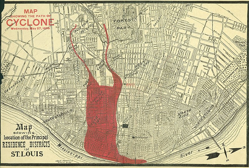
English: Title: "Map showing the path of the Cyclone, Wednesday, May 27, 1896." (superimposed on Map showing location of the Principal Residence Districts in St. Louis). In fact, it was the path of destruction of the 1896 St. Louis–East St. Louis tornado. |
| Date | |
| Source |
Missouri History Museum URL: http://images.mohistory.org/image/41042947-97FC-B4C1-70AF-8BC4CAB1C292/original.jpg Gallery: http://collections.mohistory.org/resource/150639 |
| Author | after Jas. C. Travilla |
| Permission (Reusing this file) |
UND - Copyright undetermined |
| Identifier | N00883 |
| Part of | Disasters- Oversize Floods, Shipwrecks, and Tornados |
| Subjects | Disasters |
| Resource | 150639 |
| GUID | 41042947-97FC-B4C1-70AF-8BC4CAB1C292 |
Licensing edit
.jpg&action=edit§ion=2)
|
This is a faithful photographic reproduction of a two-dimensional, public domain work of art. The work of art itself is in the public domain for the following reason:
The official position taken by the Wikimedia Foundation is that "faithful reproductions of two-dimensional public domain works of art are public domain".
This photographic reproduction is therefore also considered to be in the public domain in the United States. In other jurisdictions, re-use of this content may be restricted; see Reuse of PD-Art photographs for details. |
File history
Click on a date/time to view the file as it appeared at that time.
| Date/Time | Thumbnail | Dimensions | User | Comment | |
|---|---|---|---|---|---|
| current | 15:32, 18 August 2017 | | 8,893 × 6,024 (16.28 MB) | Fæ (talk | contribs) | Missouri History Museum. "Map showing the path of the Cyclone, Wednesday, May 27, 1896." (superimposed on Map showing location of the Principal Residence Districts in St. Louis). 1865to1899 #277.8 of 339 |
You cannot overwrite this file.
File usage on Commons
There are no pages that use this file.
File usage on other wikis
The following other wikis use this file:
- Usage on de.wikipedia.org
- Usage on en.wikipedia.org
.jpg&oldid=874563704)