File:Île du Levant topographic map-fr.svg

Size of this PNG preview of this SVG file: 780 × 599 pixels. Other resolutions: 313 × 240 pixels | 625 × 480 pixels | 1,000 × 768 pixels | 1,280 × 983 pixels | 2,560 × 1,967 pixels | 1,623 × 1,247 pixels.
Original file (SVG file, nominally 1,623 × 1,247 pixels, file size: 982 KB)
Captions
Captions
Add a one-line explanation of what this file represents
Summary edit
| Description | |||||
| Date | |||||
| Source |
Own work
|
||||
| Creator | |||||
| Permission (Reusing this file) |
|
||||
| Geotemporal data | |||||
| Date depicted | |||||
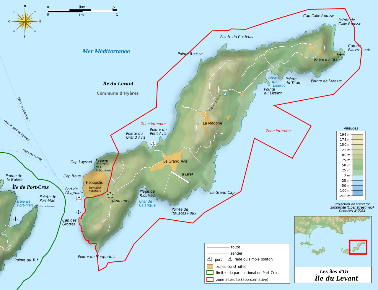
| Map location | Île du Levant | ||||
| Map type | topographic map | ||||
| Spatial reference system |
plate carrée ; système géodésique WGS84 ; Shaded relief: image of N-W lightning position |
||||
| Scale | 1:17 857 | ||||
| Heading |
 |
||||
| Bounding box |
|
||||
| Bibliographic data | |||||
| Language | French | ||||
| Archival data | |||||
| Medium | color | ||||
| Notes |
Software :
|
||||
| Other versions | Template:Other versions/Île du Levant map | ||||


|
This SVG file contains embedded text that can be translated into your language, using any capable SVG editor, text editor or the SVG Translate tool. For more information see: About translating SVG files. |
This W3C-unspecified vector image was created with Inkscape .
Licensing edit
I, the copyright holder of this work, hereby publish it under the following licenses:

|
Permission is granted to copy, distribute and/or modify this document under the terms of the GNU Free Documentation License, Version 1.2 or any later version published by the Free Software Foundation; with no Invariant Sections, no Front-Cover Texts, and no Back-Cover Texts. A copy of the license is included in the section entitled GNU Free Documentation License. |
This file is licensed under the Creative Commons Attribution-Share Alike 3.0 Unported, 2.5 Generic, 2.0 Generic and 1.0 Generic license.
- You are free:
- to share – to copy, distribute and transmit the work
- to remix – to adapt the work
- Under the following conditions:
- attribution – You must give appropriate credit, provide a link to the license, and indicate if changes were made. You may do so in any reasonable manner, but not in any way that suggests the licensor endorses you or your use.
- share alike – If you remix, transform, or build upon the material, you must distribute your contributions under the same or compatible license as the original.
You may select the license of your choice.
File history
Click on a date/time to view the file as it appeared at that time.
| Date/Time | Thumbnail | Dimensions | User | Comment | |
|---|---|---|---|---|---|
| current | 21:21, 15 March 2011 | | 1,623 × 1,247 (982 KB) | Bourrichon (talk | contribs) | relief ombré déplacé |
| 21:08, 15 March 2011 |  | 1,623 × 1,247 (1.04 MB) | Bourrichon (talk | contribs) | couleur orange | |
| 21:04, 15 March 2011 |  | 1,623 × 1,247 (1.04 MB) | Bourrichon (talk | contribs) | == {{int:filedesc}} == {{Location|20|15|00|S|57|35|00|E|scale:500000}} {{Information |Description= {{fr|Carte topographique en français de l'fr:Île du Levant}}{{de|Topographische Karte zum die de:Île du Levant, in Französische}}{{en|Topogr |
You cannot overwrite this file.
File usage on Commons
There are no pages that use this file.
File usage on other wikis
The following other wikis use this file:
- Usage on el.wikipedia.org
- Usage on fr.wikipedia.org
- Île du Levant
- Discussion:Île du Levant
- Wikipédia:Atelier graphique/Cartes/Archives/septembre 2011
- Abbaye du Castelas
- Discussion:Île du Levant/LSV 17433
- Wikipédia:Statistiques des anecdotes de la page d'accueil/Visibilité des anecdotes (2019)/2019 12
- Projet:Aide et accueil/Twitter/Tweets/archives/décembre 2019
- Wikipédia:Wikimag/2019/52
- Wikipédia:Le saviez-vous ?/Archives/2019
- Usage on it.wikipedia.org
- Usage on pl.wikivoyage.org
- Usage on ru.wikipedia.org