File:Östliches Mittelmeer 1450 DE.svg

Size of this PNG preview of this SVG file: 633 × 599 pixels. Other resolutions: 253 × 240 pixels | 507 × 480 pixels | 811 × 768 pixels | 1,081 × 1,024 pixels | 2,163 × 2,048 pixels | 2,529 × 2,395 pixels.
Original file (SVG file, nominally 2,529 × 2,395 pixels, file size: 201 KB)
Captions
Captions
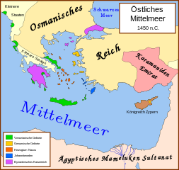
German language version of map on political situation in Eastern Mediterranean in 1450.
Summary edit
| Description | Politische Karte des östliche Mittelmeers im Jahre 1450. |
| Date | (UTC) |
| Source |
This file was derived from: Eastern Mediterranean 1450.svg: |
| Author |
|
| Other versions |
[]
|


| This is a retouched picture, which means that it has been digitally altered from its original version. Modifications: Übertragung der Karte ins Deutsche. The original can be viewed here: Eastern Mediterranean 1450.svg:
|
Licensing edit
This file is licensed under the Creative Commons Attribution-Share Alike 3.0 Unported license.
- You are free:
- to share – to copy, distribute and transmit the work
- to remix – to adapt the work
- Under the following conditions:
- attribution – You must give appropriate credit, provide a link to the license, and indicate if changes were made. You may do so in any reasonable manner, but not in any way that suggests the licensor endorses you or your use.
- share alike – If you remix, transform, or build upon the material, you must distribute your contributions under the same or compatible license as the original.
Original upload log edit
This image is a derivative work of the following images:
- File:Eastern_Mediterranean_1450_.svg licensed with Cc-by-sa-2.5
- 2007-10-16T16:15:53Z MapMaster 2529x2395 (340853 Bytes) small fix
- 2007-09-09T18:56:03Z MapMaster 2529x2395 (340171 Bytes) Further slight changes, particularly Thessaloniki.
- 2007-09-09T04:23:48Z MapMaster 2529x2395 (342637 Bytes) More changes based on Alekkas' research.
- 2007-09-07T03:50:51Z MapMaster 2529x2395 (356148 Bytes) Slight modifications based on information from [[User:Alekkas]] on my talk page.
- 2007-04-17T03:08:03Z MapMaster 2529x2395 (355411 Bytes) Added missing text
- 2007-04-14T05:20:46Z MapMaster 2529x2395 (329143 Bytes) slight update
- 2007-04-13T20:52:25Z MapMaster 2529x2395 (323087 Bytes) A political map of the eastern Mediterranean Sea, in 1450.
Uploaded with derivativeFX
File history
Click on a date/time to view the file as it appeared at that time.
| Date/Time | Thumbnail | Dimensions | User | Comment | |
|---|---|---|---|---|---|
| current | 20:18, 14 March 2013 | | 2,529 × 2,395 (201 KB) | Lokiseinchef (talk | contribs) | byzantinische Inseln in der Nordägäis entsprechend eingefärbt (correctly coloured Byzantine Empire's islands in northern Aegean Sea) |
| 10:42, 26 January 2012 |  | 2,529 × 2,395 (223 KB) | Lokiseinchef (talk | contribs) | Rechtschreibfehler entfernt... sry, erste Bildbearbeitung überhaupt | |
| 10:37, 26 January 2012 |  | 2,529 × 2,395 (223 KB) | Lokiseinchef (talk | contribs) | Schrift erneut verschoben | |
| 10:21, 26 January 2012 |  | 2,529 × 2,395 (223 KB) | Lokiseinchef (talk | contribs) | Schriftposition angepasst | |
| 10:18, 26 January 2012 |  | 2,529 × 2,395 (222 KB) | Lokiseinchef (talk | contribs) | == {{int:filedesc}} == {{Information |Description=== Politische Karte des östliche Mittelmeers im Jahre 1450. |Source={{Derived from|Eastern_Mediterranean_1450_.svg|display=50}} |Date=2012-01-26 10:15 (UTC) |Author=*[[:File:Eastern_Mediterranean_1450_.sv |
You cannot overwrite this file.
File usage on Commons
The following 22 pages use this file:
- File:Bütsants1450.png
- File:Eastern Mediterranean 1450- sr lat.svg
- File:Eastern Mediterranean 1450-hu.svg
- File:Eastern Mediterranean 1450-ru.svg
- File:Eastern Mediterranean 1450-sr.svg
- File:Eastern Mediterranean 1450-zh.svg
- File:Eastern Mediterranean 1450.svg
- File:Eastern Mediterranean 1450 -HE.svg
- File:Eastern Mediterranean 1450 - Arabic.PNG
- File:Eastern Mediterranean 1450 - HE.svg
- File:Eastern Mediterranean 1450 el.svg
- File:Eastern Mediterranean 1450 es.svg
- File:Eastern Mediterranean 1450 pt.svg
- File:Eastern Mediterranean 1450 tr.png
- File:Eastern Mediterranean in 1450-hy.png
- File:Mediterraneo Orientale 1450.svg
- File:Mediterráneo Oriental 1450 d.C.svg
- File:Mediteràneo Orientàl 1450 - lmo.svg
- File:MéditerranéeOrient1450.PNG
- File:Se Easterna Wendelsæ in 1450.svg
- File:Östliches Mittelmeer 1450 DE.svg
- Template:Other versions/Eastern Mediterranean 1450
File usage on other wikis
The following other wikis use this file:
- Usage on de.wikipedia.org
- Usage on stq.wikipedia.org