File:Świeszyno (gmina) location map.png

Size of this preview: 546 × 599 pixels. Other resolutions: 219 × 240 pixels | 437 × 480 pixels | 767 × 842 pixels.
Original file (767 × 842 pixels, file size: 102 KB, MIME type: image/png)
Captions
Captions
Add a one-line explanation of what this file represents
| Description |
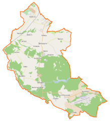
Polski: Mapa gminy Świeszyno, Polska
English: Map of Gmina Świeszyno, Poland |
|||||||||
| Date | ||||||||||
| Source | You may find a page on the OpenStreetMap wiki page for Świeszyno (gmina) | |||||||||
| Creator |
OpenStreetMap contributors OpenStreetMap contributors |
|||||||||
| Permission (Reusing this file) |
OpenStreetMap data is available under the Open Database License (details). Map tiles are licensed under the Creative Commons Attribution-ShareAlike 2.0 license (CC-BY-SA 2.0).
This file is licensed under the Creative Commons Attribution-Share Alike 2.0 Generic license.
|
|||||||||
| Geotemporal data | ||||||||||
| Bounding box |
|
|||||||||
| Georeferencing | If inappropriate please set warp_status = skip to hide. | |||||||||
File history
Click on a date/time to view the file as it appeared at that time.
| Date/Time | Thumbnail | Dimensions | User | Comment | |
|---|---|---|---|---|---|
| current | 07:40, 27 March 2015 | | 767 × 842 (102 KB) | VanWiel (talk | contribs) | {{OpenStreetMap | name = Świeszyno (gmina) | location = Świeszyno (gmina) | description = {{pl|Mapa gminy Świeszyno, Polska}} {{en|Map of Gmina Świeszyno, Poland}} | top = 54.1827 | bottom = 54.... |
You cannot overwrite this file.
File usage on Commons
There are no pages that use this file.
File usage on other wikis
The following other wikis use this file:
- Usage on fr.wikipedia.org
- Świeszyno (Poméranie-Occidentale)
- Bagno (Poméranie-Occidentale)
- Bardzlino
- Biała Kępa
- Brzeźniki
- Chałupy (Poméranie-Occidentale)
- Chłopska Kępa
- Czacz (Poméranie-Occidentale)
- Czaple (Poméranie-Occidentale)
- Czersk Koszaliński
- Dunowo
- Giezkowo
- Golica (Pologne)
- Jarzyce
- Kępa Świeszyńska
- Kłokęcin
- Konikowo (Poméranie-Occidentale)
- Krokowo (Poméranie-Occidentale)
- Kurozwęcz
- Mierzym
- Niedalino
- Niekłonice
- Olszak (Poméranie-Occidentale)
- Sieranie
- Strzekęcino
- Węgorki (Poméranie-Occidentale)
- Wiązogóra
- Włoki
- Zegrze Pomorskie
- Zegrzyn
- Usage on pl.wikipedia.org
- Świeszyno (gmina)
- Dunowo
- Mierzym
- Niekłonice
- Niedalino
- Zegrze Pomorskie
- Konikowo (województwo zachodniopomorskie)
- Świeszyno (województwo zachodniopomorskie)
- Kurozwęcz
- Niekłonice (przystanek kolejowy)
- Strzekęcino
- Giezkowo
- Bardzlino
- Golica (województwo zachodniopomorskie)
- Jarzyce
- Czaple (województwo zachodniopomorskie)
- Dunowo (przystanek kolejowy)
- Czersk Koszaliński
- Biała Kępa
- Sieranie
View more global usage of this file.
_location_map.png)
_location_map.png&oldid=484829039)