File:Карта распределения армянского населения в Турецкой Армении и Курдистане с пояснительною запискою, 1895.jpg

Original file (2,304 × 1,809 pixels, file size: 1.49 MB, MIME type: image/jpeg)
Captions
Captions
Summary edit
| Description |
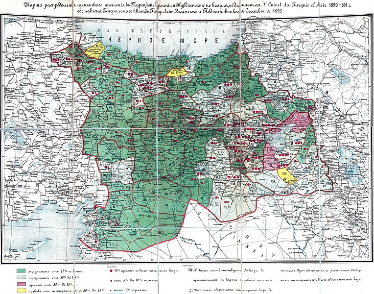
English: Map of the distribution of the Armenian (also other Christian) and Muslim population in Turkish (Western) Armenia and neighboring regions of Ottoman empire in 1895. Map is created by general-lieutenant Zelyoniy and colonel Sysoev of the military headquarter of the Russian imperial army in 1895. This map is based on the work of V. Cuinet "La Turquie d'Asie 1890-1894".
more than %75 Muslim population
%50 - %75 Muslim population
%50 - %75 Armenian population
%50 - %75 Greek and Nestoriyan population Русский: Карта распределения армянского населения в Турецкой Армении и Курдистане с пояснительною запискою 1895 года Генерального Штаба генерал-лейтенанта А. С. Зеленого и подполковника Сысоева по данным сочинения V. Cuinet "La Turquie d'Asie 1890-1894". |
| Date | |
| Source | Зеленый А. С. Карта распределения армянского населения в Турецкой Армении и Курдистане с пояснительною запискою Генерального Штаба генерал-лейтенанта Зеленого и подполковника Сысоева. Спб., 1895 |
| Author | А. С. Зеленый |
Licensing edit
This work was published on territory of the Russian Empire (Russian Republic) except for territories of the Grand Duchy of Finland and Congress Poland before 7 November 1917 and wasn't re-published for 30 days following initial publications on the territory of Soviet Russia or any other countries.
The Russian Federation (early Soviet Russia, RSFSR) is the historical heir but not legal successor of the Russian Empire, and the Russian Empire was not party to the Berne Convention (it was not country of Union for the protection of the rights of authors in their literary and artistic works), so according to article 5 of the Convention this work has no country of origin except:
¹ - Author who is not a national of a country of the Union but who has his habitual residence in a country of the Union, be assimilated to national of that country. The exclusive rights to this work do not extend on territory of the Russian Federation according to article 1256 of the Civil Code of the Russian Federation (details), because this work does not meet the requirements on the territory of publication, on the author's nationality, and on obligations for international treaties. If applicable, {{PD-Russia-expired}} should be used instead of this tag. This work is in the public domain in the United States because it was published (or registered with the U.S. Copyright Office) before January 1, 1929. |
 |
This work is in the public domain in Russia according to article 1256 of Book IV of the Civil Code of the Russian Federation No. 230-FZ of December 18, 2006 (details). It was published on territory of the Russian Empire (Russian Republic) except for territories of the Grand Duchy of Finland and Congress Poland before 7 November 1917 and wasn't re-published for 30 days following initial publications on the territory of Soviet Russia or any other states.
The Russian Federation (early RSFSR, Soviet Russia) is the historical heir but not legal successor of the Russian Empire.
If applying,
|
This work is in the public domain in its country of origin and other countries and areas where the copyright term is the author's life plus 100 years or fewer. | |
| This file has been identified as being free of known restrictions under copyright law, including all related and neighboring rights. | |
should be used instead of this tag.
This work is in the public domain in the United States because it was published (or registered with the U.S. Copyright Office) before January 1, 1924
Summary edit
Map of the distribution of the Armenian (also other Christian) and Muslim population in Turkish (Western) Armenia and neighboring regions of Ottoman empire in 1895. Map is created by general-lieutenant Zeleniy and colonel Sysoev of the military headquarter of the Russian imperial army in 1895. This map is based on the work of V. Cuinet "La Turquie d'Asie 1890-1894".
File history
Click on a date/time to view the file as it appeared at that time.
| Date/Time | Thumbnail | Dimensions | User | Comment | |
|---|---|---|---|---|---|
| current | 20:04, 24 March 2019 | | 2,304 × 1,809 (1.49 MB) | Jacques-Yves Cousteau (talk | contribs) | Map of the distribution of the Armenian (also other Christian) and Muslim population in Turkish (Western) Armenia and neighboring regions of Ottoman empire in 1895. Map is created by general-lieutenant Zeleniy and colonel Sysoev of the military headquarter of the Russian imperial army in 1895. This map is based on the work of V. Cuinet "La Turquie d'Asie 1890-1894". |
You cannot overwrite this file.
File usage on Commons
The following page uses this file:
File usage on other wikis
The following other wikis use this file:
- Usage on ar.wikipedia.org
- Usage on en.wikipedia.org
- Usage on fr.wikipedia.org
- Usage on it.wikipedia.org
- Usage on pnb.wikipedia.org
- Usage on sr.wikipedia.org
- Usage on tr.wikipedia.org
- Usage on ur.wikipedia.org