File:Одеська Миколаївська Ізмаїльська області 1947.jpg

Size of this preview: 600 × 600 pixels. Other resolutions: 240 × 240 pixels | 480 × 480 pixels | 768 × 768 pixels | 1,024 × 1,024 pixels | 2,048 × 2,048 pixels | 4,778 × 4,778 pixels.
Original file (4,778 × 4,778 pixels, file size: 11.79 MB, MIME type: image/jpeg)
Captions
Captions
Add a one-line explanation of what this file represents
Summary edit
| Description |
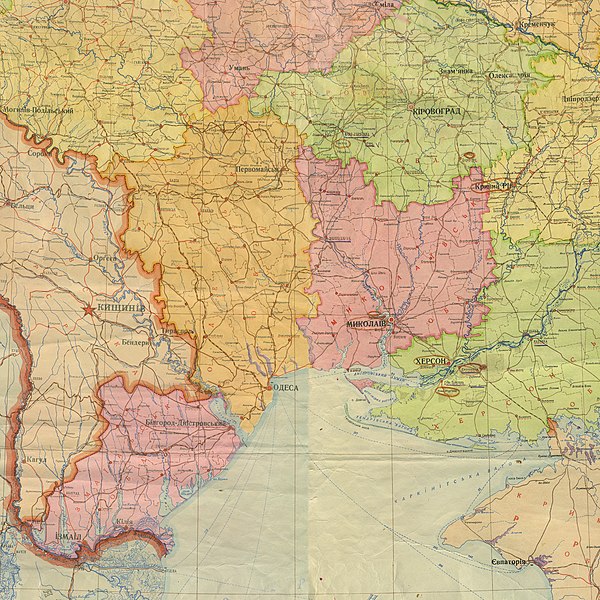
Українська: Територія Одеської, Миколаївської та Ізмаїльської областей, фрагмент карти Української РСР, адміністративний поділ від 1 листопада 1947 |
| Date | |
| Source | Адміністративна карта Української РСР [Карти] : адм. границі — на 1-ше листоп. 1947 р. / НРКЧ ГУГК ; відп. ред. Царева. — 1:1 000 000. — [М.] : ГУГК, [1947]. — 1 к. (4 арк.) : кольор., табл. ; 58×71 см (НБУВ СК 2036) |
| Author | Unknown author (scan by AMY 2015-01-12) |
Licensing edit
This file is a Ukrainian or Ukrainian SSR work and it is presently in the public domain in Ukraine, because it was published before January 1, 1954, and the creator (if known) died before that date (details).
|
 |
File history
Click on a date/time to view the file as it appeared at that time.
| Date/Time | Thumbnail | Dimensions | User | Comment | |
|---|---|---|---|---|---|
| current | 22:02, 16 August 2018 | | 4,778 × 4,778 (11.79 MB) | AMY 81-412 (talk | contribs) | == {{int:filedesc}} == {{Information |description={{uk|1=Територія Одеської, Миколаївської та Ізмаїльської областей, фрагмент карти Української РСР, адміністративний поділ від 1 листопада 1947}} |date=1947-11-01 |source= Адміністративна карта Української РСР [Карти] : адм. границі — на 1-ше листоп. 1947 р. / НРКЧ ГУГК ; відп. ред. Царева. — 1:1 000 000. — [М.] : ГУГК, [1947]. — 1 к. (4 арк.) : кольор., табл. ; 58×71 см (НБУВ СК 2036) |author={{unknown|author}} (scan by AMY 2015-01-12) |permis... |
You cannot overwrite this file.
File usage on Commons
The following page uses this file:
File usage on other wikis
The following other wikis use this file:
- Usage on en.wikipedia.org
- Usage on pl.wikipedia.org
- Usage on uk.wikipedia.org